

Adaption to extreme rainfall with open urban drainage system: an integrated hydrological cost-benefit analysis
- PMID: 23334752
- PMCID: PMC3579472
- DOI: 10.1007/s00267-012-0010-8
Adaption to extreme rainfall with open urban drainage system: an integrated hydrological cost-benefit analysis
Abstract
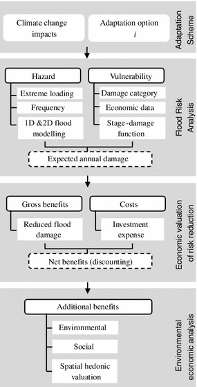
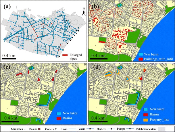
This paper presents a cross-disciplinary framework for assessment of climate change adaptation to increased precipitation extremes considering pluvial flood risk as well as additional environmental services provided by some of the adaptation options. The ability of adaptation alternatives to cope with extreme rainfalls is evaluated using a quantitative flood risk approach based on urban inundation modeling and socio-economic analysis of corresponding costs and benefits. A hedonic valuation model is applied to capture the local economic gains or losses from more water bodies in green areas. The framework was applied to the northern part of the city of Aarhus, Denmark. We investigated four adaptation strategies that encompassed laissez-faire, larger sewer pipes, local infiltration units, and open drainage system in the urban green structure. We found that when taking into account environmental amenity effects, an integration of open drainage basins in urban recreational areas is likely the best adaptation strategy, followed by pipe enlargement and local infiltration strategies. All three were improvements compared to the fourth strategy of no measures taken.
Figures
References
-
- Anselin L. Spatial econometrics: methods and models. Boston: Kluwer Academic; 1988.
-
- Anselin L. Thirty years of spatial econometrics. Pap Reg Sci. 2010;89(1):3–25. doi: 10.1111/j.1435-5957.2010.00279.x. - DOI
-
- Anthon S, Thorsen BJ, Helles F. Urban-fringe afforestation projects and taxable hedonic values. Urban For Urban Green. 2005;3(2):79–91. doi: 10.1016/j.ufug.2004.09.004. - DOI
-
- ArcGIS (9.3) ArcGIS Desktop, ArcInfo. ESRI
Publication types
MeSH terms
LinkOut - more resources
Full Text Sources
Other Literature Sources
Medical
