

Spatial analysis of health effects of large industrial incinerators in England, 1998-2008: a study using matched case-control areas
- PMID: 23355655
- PMCID: PMC3563137
- DOI: 10.1136/bmjopen-2012-001847
Spatial analysis of health effects of large industrial incinerators in England, 1998-2008: a study using matched case-control areas
Abstract
Objectives: To assess whether residential proximity to industrial incinerators in England is associated with increased risk of cancer incidence and mortality.
Design: Retrospective study using matched case-control areas.
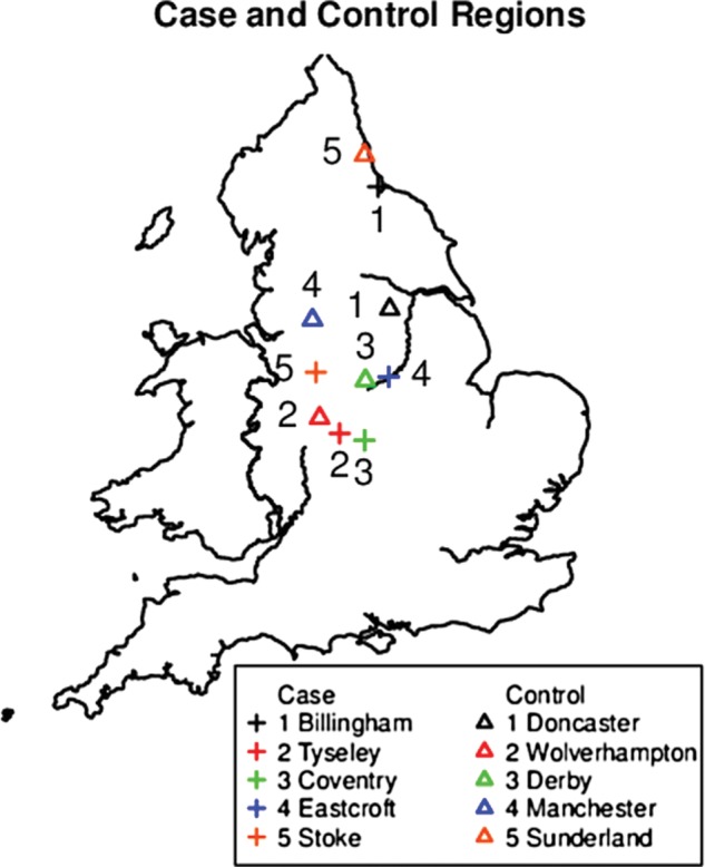
Setting: Five circular regions of radius 10 km near industrial incinerators in England (case regions) and five matched control regions, 1998-2008.
Participants: All cases of diseases of interest within the circular areas.
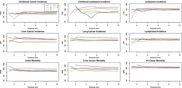
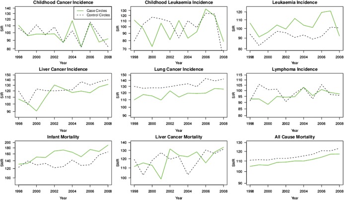
Primary and secondary outcome measures: Counts of childhood cancer incidence (<15 years); childhood leukaemia incidence (<15 years); leukaemia incidence; liver cancer incidence; lung cancer incidence; non-Hodgkin's lymphoma incidence; all-cause mortality; infant mortality (<1 year) and liver cancer mortality.
Results: The estimated relative risks for case circles versus control circles for the nine outcomes considered range from 0.94 to 1.14, and show neither elevated risk in case circles compared to control areas nor elevated risk with proximity to incinerators within case circles.
Conclusions: This study applies statistical methods for analysing spatially referenced health outcome data in regions with a hypothesised exposure relative to matched regions with no such exposure. There is no evidence of elevated risk of cancer incidence or mortality in the vicinity of large industrial incinerators in England.
Figures
Similar articles
-
[SENTIERI - Epidemiological Study of Residents in National Priority Contaminated Sites. Sixth Report].Epidemiol Prev. 2023 Jan-Apr;47(1-2 Suppl 1):1-286. doi: 10.19191/EP23.1-2-S1.003. Epidemiol Prev. 2023. PMID: 36825373 Italian.
-
Results of case-control study of leukaemia and lymphoma among young people near Sellafield nuclear plant in West Cumbria.BMJ. 1990 Feb 17;300(6722):423-9. doi: 10.1136/bmj.300.6722.423. BMJ. 1990. PMID: 2107892 Free PMC article.
-
Distribution of childhood leukaemias and non-Hodgkin's lymphomas near nuclear installations in England and Wales.BMJ. 1994 Aug 20-27;309(6953):501-5. doi: 10.1136/bmj.309.6953.501. BMJ. 1994. PMID: 8086902 Free PMC article.
-
Environmental and individual exposure and the risk of congenital anomalies: a review of recent epidemiological evidence.Epidemiol Prev. 2018 May-Aug;42(3-4 Suppl 1):1-34. doi: 10.19191/EP18.3-4.S1.P001.057. Epidemiol Prev. 2018. PMID: 30066535 Review. English.
-
Mortality and Morbidity Effects of Long-Term Exposure to Low-Level PM2.5, BC, NO2, and O3: An Analysis of European Cohorts in the ELAPSE Project.Res Rep Health Eff Inst. 2021 Sep;2021(208):1-127. Res Rep Health Eff Inst. 2021. PMID: 36106702 Free PMC article.
Cited by
-
A review of exposure assessment methods in epidemiological studies on incinerators.J Environ Public Health. 2013;2013:129470. doi: 10.1155/2013/129470. Epub 2013 Jun 12. J Environ Public Health. 2013. PMID: 23840228 Free PMC article. Review.
-
Methodological approaches to the study of cancer risk in the vicinity of pollution sources: the experience of a population-based case-control study of childhood cancer.Int J Health Geogr. 2019 May 28;18(1):12. doi: 10.1186/s12942-019-0176-x. Int J Health Geogr. 2019. PMID: 31138300 Free PMC article.
-
Estimating Particulate Exposure from Modern Municipal Waste Incinerators in Great Britain.Environ Sci Technol. 2017 Jul 5;51(13):7511-7519. doi: 10.1021/acs.est.6b06478. Epub 2017 Jun 16. Environ Sci Technol. 2017. PMID: 28621543 Free PMC article.
References
-
- Colls J. Air pollution. 2nd edn London: and New York: Spon Press, 2002: chapter 1.7
-
- Gouveia N, Ruscitto RP. Spatial analysis of the health risks associated with solid waste incineration: a preliminary analysis. Rev Bras Epidemiol 2010;13:3–10 - PubMed
LinkOut - more resources
Full Text Sources
Other Literature Sources