. 2013:3:1277.
doi: 10.1038/srep01277.

La Niña forces unprecedented Leeuwin Current warming in 2011

Affiliations

La Niña forces unprecedented Leeuwin Current warming in 2011

Ming Feng et al. Sci Rep. 2013.

Abstract

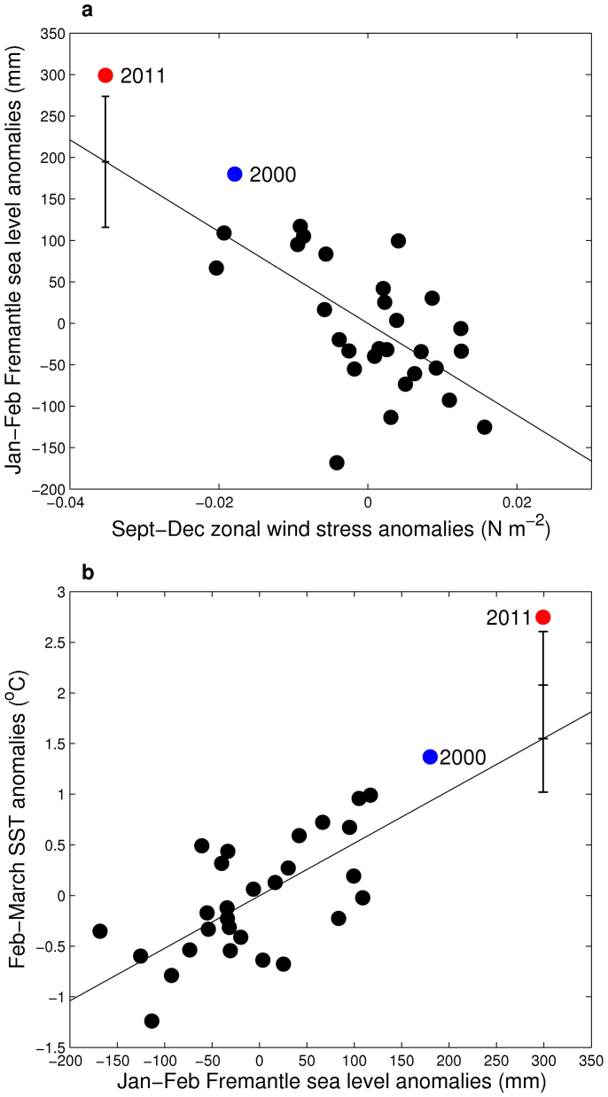
Unprecedented warm sea surface temperature (SST) anomalies were observed off the west coast of Australia in February-March 2011. Peak SST during a 2-week period were 5°C warmer than normal, causing widespread coral bleaching and fish kills. Understanding the climatic drivers of this extreme event, which we dub "Ningaloo Niño", is crucial for predicting similar events under the influence of global warming. Here we use observational data and numerical models to demonstrate that the extreme warming was mostly driven by an unseasonable surge of the poleward-flowing Leeuwin Current in austral summer, which transported anomalously warm water southward along the coast. The unusual intensification of the Leeuwin Current was forced remotely by oceanic and atmospheric teleconnections associated with the extraordinary 2010-2011 La Niña. The amplitude of the warming was boosted by both multi-decadal trends in the Pacific toward more La Niña-like conditions and intraseasonal variations in the Indian Ocean.


Figures

Figure 1
Figure 1. Monthly time series of key indices.
(a), Niño 3.4 area sea surface temperature and Southern Oscillation Index (scaled down by a factor of 10). (b), zonal wind stress anomalies averaged over 3°S – 3°N, 130 – 160°E in the equatorial Pacific, where the zonal wind anomalies lead the Fremantle sea level on interannual time scales, and meridional wind stress anomalies off the west coast of Australia averaged over 30° – 22°S, 110° – 116°E, as derived from the Tropflux product. (c), Fremantle sea level anomalies, as an index of the strength of the Leeuwin Current off the west coast of Australia. (d), Sea surface temperature anomalies averaged over 32 – 26°S, 112 – 115°E off the west coast of Australia (where the interannual temperature variation is largely responding to the Leeuwin Current heat transport), derived from the OISST. (e), Upper ocean (0–150 m) heat content anomalies off northwest Australia (22°–15°S, 108°–114°E), the key forcing region of the Leeuwin Current, derived from GODAS reanalysis. The red curve in (d) is derived from TMI SST product. Anomalies in (b), (c), (d) and (e) are smoothed with a 5-point Hanning filter. A linear trend of 1.6 mm per year has been removed from the Fremantle sea level to account for the global sea level rising trend during the past century.
Figure 2
Figure 2. Sea level, sea surface temperature, and wind stress anomalies.
(a), One-month lead correlations of Global Ocean Data Assimilation System (GODAS) sea level anomalies (colour shading) and NCEP-DOE reanalysis-2 surface wind anomalies (vector) with Fremantle sea level anomalies (only correlations > 0.3 are shown). (b), GODAS sea level anomalies averaged between December 2010 and January 2011. (c), Sea surface temperature anomalies averaged between February and March 2011. The boxes in (b) denote the regions in the equatorial Pacific and off the west coast of Australia where average wind anomalies were calculated in Fig. 1b, and the boxes in (c) denotes the regions of average sea surface temperature anomalies used in Fig. 1d and average heat content used in Fig. 1e.
Figure 3
Figure 3. Relationships between equatorial western Pacific zonal wind, Fremantle sea level, and the sea surface temperature anomalies off the west coast of Australia.
(a), Scatter plot between September-December averaged zonal wind stress anomalies in the equatorial western Pacific (3°S–3°N, 130°–160°E) and the following January-February averaged Fremantle sea level anomalies during 1982–2011. (b), Scatter plot between January-February averaged Fremantle sea level anomalies and February-March averaged sea surface temperature anomalies off the west coast of Australia (32°–26°S, 112°–115°E) during 1982–2011. The thin solid lines denote the linear regression between the indices for all years excluding 2011, and the standard errors of linear regression predictions for January-February 2011 Fremantle sea level and February-March 2011 temperatures are indicated (two standard error is also denoted for the temperature prediction).
Figure 4
Figure 4. Leeuwin Current volume and heat transports.
(a), Observed monthly Fremantle sea levels during 2010–2011 (heavy line). (b), Monthly Leeuwin Current volume transport across 25°S during 2010–2011 (heavy line) as derived from Global Ocean Data Assimilation System (GODAS). (c), Sea surface temperature off the Western Australia coast from OISST in February 2011. The light lines and grey shading in (a) and (b) denotes climatology mean and ±1 monthly standard deviation.
Figure 5
Figure 5. Mean sea level pressure anomalies in December 2010 and February 2011.
(a), (c), derived from the NCEP-DOE Reanalysis-2, relative to the 1980–2011 average climatology. (b), (d), derived from a 3-member composite of an atmospheric model simulation forced by observed ocean sea surface temperatures. The 925 mb wind anomalies are denoted by arrows.
Figure 6
Figure 6. Ocean temperatures at the peak of the extreme warming event.
(a), Sea surface temperature anomalies during 21 February – 6 March 2011 at the peak of the extreme warming event. (b), A zoomed-in view of the temperature anomaly pattern off the west coast of Australia. (c), Daily sea surface temperature during January – April 2011 for the region off the west coast of Australia (averaged over 28° – 32°S, 112° – 115°E). (d), (e), wind direction and speed at the coastal station on the Rottnest Island. 180 denote southerly winds so that the winds are dominantly southeastlies. (f), Daily air temperatures measured at the coastal station on the Rottnest Island. (g), Moored temperature observations on the continental shelf off Western Australia coast (31°59.0'S, 115°14.0'E). The blue dotted line denotes the surface mixed layer depth (defined as 0.5°C from the surface temperature). (h), Temperature profiles observed before (18 January 2011) and at the peak (7 March) of the maximum temperature anomalies observed from an Argo float located to the west of the warming centre. (i), Temperature anomalies of the Argo profiles from the CSIRO Atlas of Regional Seas (CARS) climatology. The locations of Rottnest Island, Fremantle, shelf mooring and Argo profiles are denoted in (b).
Figure 7
Figure 7. Schematic of the 2010–2011 La Niña influences on the Western Australia coast.
(a), May 2010 when the Indian Ocean basin warming after the 2009–2010 El Niño event induced easterly wind anomalies in the equatorial western Pacific, which led to the quick transition from El Niño to La Niña conditions in the tropical Pacific. (b), December 2010 at the peak of the La Niña event. (c), February 2011 at the peak of the extreme warming event off the west coast of Australia. The red and blue areas denote the main positive and negative SST anomalies in the Pacific and Indian Ocean; the light blue areas denote low sea level pressure anomalies in the southeast Indian Ocean and the dashed arrows are the associated wind anomalies; the large arrows denote zonal wind anomalies along the equator in the Pacific and Indian Oceans. In (a), the ocean surface currents in the southeast Indian Ocean are sketched (ITF: Indonesian Throughflow; LC: Leeuwin Current) and the gray curved arrows in the top panel denote the equatorial and coastal waveguides through which the equatorial Pacific wind anomalies affect the strength of the Leeuwin Current. The clouds in (b) and (c) denote the locations of atmospheric deep convection related to the La Niña as shown in outgoing longwave radiation data.

References

    1. Walther G. R. et al. Ecological responses to recent climate change. Nature 416, 389–395 (2002). - PubMed
    1. Sexton J. P., McIntyre P. J., Angert A. L. & Rice K. J. Evolution and ecology of species range limits. Annu. Rev. Ecol. Evol. Syst. 40, 415–436 (2009).
    1. Conover D. O. & Present T. M. C. Countergradient variation in growth rate: compensation for length of the growing season among Atlantic silversides from different latitudes. Oecologia 83, 316–324 (1990). - PubMed
    1. Byrne M. Impact of ocean warming and ocean acidification on marine invertebrate life history stages: vulnerabilities and potential for persistence in a changing ocean. Oceanogr. Mar. Biol. Ann. Rev. 49, 1–43 (2011).
    1. Peck L. S., Webb K. E. & Bailey D. M. Extreme sensitivity of biological function to temperature in Antarctic marine species. Functional Ecology 18, 625–630 (2004).

Publication types

LinkOut - more resources