

The value of wetlands in protecting southeast louisiana from hurricane storm surges
- PMID: 23536815
- PMCID: PMC3594144
- DOI: 10.1371/journal.pone.0058715
The value of wetlands in protecting southeast louisiana from hurricane storm surges
Abstract
The Indian Ocean tsunami in 2004 and Hurricanes Katrina and Rita in 2005 have spurred global interest in the role of coastal wetlands and vegetation in reducing storm surge and flood damages. Evidence that coastal wetlands reduce storm surge and attenuate waves is often cited in support of restoring Gulf Coast wetlands to protect coastal communities and property from hurricane damage. Yet interdisciplinary studies combining hydrodynamic and economic analysis to explore this relationship for temperate marshes in the Gulf are lacking. By combining hydrodynamic analysis of simulated hurricane storm surges and economic valuation of expected property damages, we show that the presence of coastal marshes and their vegetation has a demonstrable effect on reducing storm surge levels, thus generating significant values in terms of protecting property in southeast Louisiana. Simulations for four storms along a sea to land transect show that surge levels decline with wetland continuity and vegetation roughness. Regressions confirm that wetland continuity and vegetation along the transect are effective in reducing storm surge levels. A 0.1 increase in wetland continuity per meter reduces property damages for the average affected area analyzed in southeast Louisiana, which includes New Orleans, by $99-$133, and a 0.001 increase in vegetation roughness decreases damages by $24-$43. These reduced damages are equivalent to saving 3 to 5 and 1 to 2 properties per storm for the average area, respectively.
Conflict of interest statement
Figures
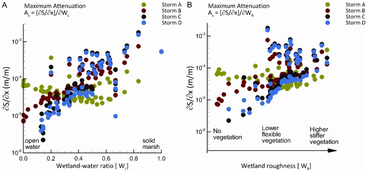
 , where WL is represented by the wetland/water ratio ranging from open water (WL = 0) to solid marsh (WL = 1). Panel B shows maximum attenuation as influenced by wetland roughness,
  , where WR is represented by Manning’s n for bottom friction caused by degrees of wetland vegetation ranging from no vegetation (WR = 0.02) to high dense vegetation (WR = 0.045). Storm A = Central pressure of 96 kPa, radius to maximum winds (Rmax) of 67 km, forward speed of 20.5 km/hr. Storm B = Central pressure of 93 kPa, radius to maximum winds (Rmax) of 47 km, forward speed of 20.5 km/hr. Storm C = Central pressure of 96 kPa, radius to maximum winds (Rmax) of 46 km, forward speed of 20.5 km/hr. Storm D = Central pressure of 93 kPa, radius to maximum winds (Rmax) of 33 km, forward speed of 11.1 km/hr.
References
-
- Koch EW, Barbier EB, Silliman BR, Reed DJ, Perillo GME, et al. (2009) Non-linearity in ecosystem services: temporal and spatial variability in coastal protection. Frontiers in Ecology & the Environment 7: 29–37.
-
- Gedan KB, Kirwan MJ, Wolanski E, Barbier EB, Silliman BR (2011) The present and future role of coastal vegetation in protecting shorelines: answering recent challenges to the paradigm. Climatic Change 106: 7–29.
-
- Coastal Protection & Restoration Authority of Louisiana (2012) Louisiana’s Comprehensive Master Plan for a Sustainable Coast. Office of Coastal Protection and Restoration, Baton Rouge, LA.
-
- Day JW Jr. Boesch DF, Clairain EJ, Kemp GP, Laska SB, et al. (2007) Restoration of the Mississippi Delta: Lessons from Hurricanes Katrina and Rita. Science 315: 1679–1684. - PubMed
Publication types
MeSH terms
LinkOut - more resources
Full Text Sources
Other Literature Sources
Medical
