. 2013:3:1677.
doi: 10.1038/srep01677.

Carbonatite ring-complexes explained by caldera-style volcanism

Affiliations

Carbonatite ring-complexes explained by caldera-style volcanism

Magnus Andersson et al. Sci Rep. 2013.

Abstract

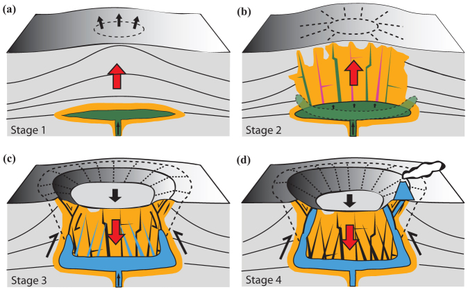
Carbonatites are rare, carbonate-rich magmatic rocks that make up a minute portion of the crust only, yet they are of great relevance for our understanding of crustal and mantle processes. Although they occur in all continents and from Archaean to present, the deeper plumbing system of carbonatite ring-complexes is usually poorly constrained. Here, we show that carbonatite ring-complexes can be explained by caldera-style volcanism. Our geophysical investigation of the Alnö carbonatite ring-complex in central Sweden identifies a solidified saucer-shaped magma chamber at ~3 km depth that links to surface exposures through a ring fault system. Caldera subsidence during final stages of activity caused carbonatite eruptions north of the main complex, providing the crucial element to connect plutonic and eruptive features of carbonatite magmatism. The way carbonatite magmas are stored, transported and erupt at the surface is thus comparable to known emplacement styles from silicic calderas.


Figures

Figure 1
Figure 1. Geological map of the Alnö alkaline and carbonatite ring complex.
Inset map shows locations of the Alnö complex in central Sweden, the coeval Fen complex in Norway and the alkaline and carbonatite intrusions of the Kola Peninsula. Locations of the reflection seismic profiles (Alnö1, 2 and 3) are shown. Additional source points were activated off the seismic profiles to increase seismic resolution at locations where there were access limitations and restrictions. Extrusive activity is preserved in the Sälskär skerries. Geological map is kindly provided by the Geological Survey of Sweden.
Figure 2
Figure 2. Velocity-density graph for samples collected from Alnö Island.
Most velocities were measured while samples were pressurized at 65 MPa. The acoustic impedance contrast between alkaline rocks, country rock migmatite and carbonatite is high, suggesting that reflections are generated if these rock types are juxtaposed. For example, jumps in the magnetic data correlate with the reflections observed on the seismic images (see Fig. 3 and Supplementary Fig. S2) and, at many locations, these magnetic highs are associated with carbonatite dykes mapped at the surface. This is consistent with our interpretation of the petrophysical measurements that carbonatites have a significant acoustic impedance contrast against most other lithologies in the study area. Number of samples used in the measurements is shown by “n” in the plot.
Figure 3
Figure 3. Post-stack depth migrated seismic section, measured, and forward calculated (see Supplementary Fig. S3), gravity and magnetic data along Alnö1 ((a) uninterpreted; (b) gravity and magnetic data; (c) interpreted).
Surface geology (as in Fig. 1) is shown along the top of the seismic profile. A complex reflectivity pattern extends down to a depth of about 3 km between Common Depth Points (CDPs) 900–1500. The transparent zone below this depth represents the location of the magma chamber from which carbonatite dykes were fed. Gently to steeply dipping reflections observed in the southern and northern parts of Alnö1 represent up-doming structures (solid red lines) associated with a saucer-shaped like magma chamber. The boundary between the dipping reflectors outside the igneous complex and the chaotic interior is marking the position of the main ring-fault system (steep dashed black lines). A good correspondence between deeper reflective zones is also observed in Alnö2 and Alnö3 (see solid black lines in Figs. 4c and 4f). Note that carbonatite dykes correlate with the measured magnetic jumps, for example between CDPs 1000 and 1200. The 2.5D forward gravity modelling along the seismic profiles supports the seismic interpretation that the main intrusion (former magma chamber) has a maximum vertical extent of ~1 km and resides at depth of about 3 to 4 km (see also Supplementary Figs. S3 and S4).
Figure 4
Figure 4. Post-stack depth migrated seismic section, measured, and forward calculated, gravity and magnetic data along Alnö2 and 3 ((a) and (d) uninterpreted; (b) and (e) gravity and magnetic data; (c) and (f) interpreted).
Surface geology (as in Fig. 1) is shown along the top of the seismic profile. Note that carbonatite dykes are well picked out by the seismic data (solid blue lines) and correlate with the measured magnetic jumps, for example at the northeasternmost part of the Alnö2 or at about CDP 400 and CDPs 750 to 800 in Alnö3. The 2.5D forward gravity modelling along the seismic profiles supports the seismic interpretation that the intrusion extends down to about 3 to 4 km depth (see Supplementary Fig. S4b and S4d).
Figure 5
Figure 5. Schematic model of the emplacement of the Alnö complex.
Stage one (a): a low-viscosity silicate magma rich in CaCO3 ascended and was trapped at about 4–5 km depth. There, it formed a laterally extensive sill-shaped magma chamber. This initiated up-doming and a surface bulge caused early radial dykes to intrude. Stage two (b): growth and inflation of this magma chamber increased tumescence of the overburden. Radial dykes and increasingly inward dipping cone-sheets were intruded into the country-rock above the chamber. Stage three (c): magma, now with a significant carbonatite fraction present, evacuated from the magma chamber via dykes leads to a pressure drop due to material withdrawal causing the central part of the roof to subside. Stage four (d): concentric outward dipping fractures form and are intruded to make ring-dykes during progressive subsidence of the central block/roof during caldera collapse. This likely caused the edges of the main chamber to migrate upwards, at which point further carbonatite dykes were intruded into reverse and normal faults in the caldera periphery, leading to eruption of carbonatite preserved in vent breccias to the north of Alnö Island (indicated to the right in (d)).

References

    1. Hisinger W. Samling till en mineralogisk geografi öfver Sverige (Nordström,H. A., Stockholm, 1808).
    1. Törnebohm A. E. Mikroskopiska bergartsstudier; XVIII Melilitbasalt från Alnö. GFF. 76, 240–251 (1883).
    1. Phipps S. P. Deep rifts as sources for alkaline intraplate magmatism in eastern North America. Nature 334, 27–31 (1988).
    1. Meert J. G., Walderhaug H. J., Torsvik T. H. & Hendriks B. W. H. Age and paleomagnetic signature of the Alnø carbonatite complex (NE Sweden): Additional controversy for the Neoproterozoic paleoposition of Baltica. Precambrian Research 154, 159–174 (2007).
    1. von Eckermann H. Boulders of volcanic breccia at the Sälskär shoals north of Alnö Island. Arkiv för mineralogi och geologi 40, 529–537 (1960).

Publication types