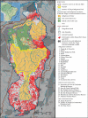
The natural and social history of the indigenous lands and protected areas corridor of the Xingu River basin
- PMID: 23610170
- PMCID: PMC3638430
- DOI: 10.1098/rstb.2012.0164
The natural and social history of the indigenous lands and protected areas corridor of the Xingu River basin
Erratum in
- Philos Trans R Soc Lond B Biol Sci. 2013 Aug 19;368(1624):20130308
Abstract
The 280,000 km² Xingu indigenous lands and protected areas (ILPAs) corridor, inhabited by 24 indigenous peoples and about 215 riverine (ribeirinho) families, lies across active agriculture frontiers in some of the historically highest-deforestation regions of the Amazon. Much of the Xingu is anthropogenic landscape, densely inhabited and managed by indigenous populations over the past millennium. Indigenous and riverine peoples' historical management and use of these landscapes have enabled their long-term occupation and ultimately their protection. The corridor vividly demonstrates how ILPAs halt deforestation and why they may account for a large part of the 70 per cent reduction in Amazon deforestation below the 1996-2005 average since 2005. However, ongoing and planned dams, road paving, logging and mining, together with increasing demand for agricultural commodities, continued degradation of upper headwaters outside ILPA borders and climate change impacts may render these gains ephemeral. Local peoples will need new, bottom-up, forms of governance to gain recognition for the high social and biological diversity of these territories in development policy and planning, and finance commensurate with the value of their ecosystem services. Indigenous groups' reports of changing fire and rainfall regimes may themselves evidence climate change impacts, a new and serious threat.
Figures


References
-
- Soares-Filho B, et al. 2010. Role of Brazilian Amazon protected areas in climate change mitigation. Proc. Natl Acad. Sci. USA 107, 10 821–10 82610.1073/pnas.0913048107 (doi:10.1073/pnas.0913048107) - DOI - DOI - PMC - PubMed
-
- IBGE. 2010. Base Cartográfica Contínua, ao Milionésimo – BCIM v. 3.0. Rio de Janeiro, Brazil.
-
- Villas-Boas A. De Olho na Bacia do Xingu. 2012. Série Cartô Brasil Socioambeintal, v. 5. São Paulo, Brazil: Instituto Socioambiental.
-
- INPE. 2010. Projeto Prodes: Monitoramento da Floresta Amazônica por Satélite. See http://www.obt.inpe.br/prodes/ (accessed March 13, 2013).
-
- Instituto Socioambiental 2013. Amazônia bajo presión. Red Amazônica de información socioambiental georrferenciada (RAISG). São Paulo, Brazil: Instituto Socioambiental
Publication types
MeSH terms
LinkOut - more resources
Full Text Sources
Other Literature Sources
Miscellaneous

