Pre-Miocene birth of the Yangtze River
- PMID: 23610418
- PMCID: PMC3651491
- DOI: 10.1073/pnas.1216241110
Pre-Miocene birth of the Yangtze River
Abstract
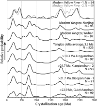
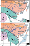
The development of fluvial systems in East Asia is closely linked to the evolving topography following India-Eurasia collision. Despite this, the age of the Yangtze River system has been strongly debated, with estimates ranging from 40 to 45 Ma, to a more recent initiation around 2 Ma. Here, we present (40)Ar/(39)Ar ages from basalts interbedded with fluvial sediments from the lower reaches of the Yangtze together with detrital zircon U-Pb ages from sand grains within these sediments. We show that a river containing sediments indistinguishable from the modern river was established before ~23 Ma. We argue that the connection through the Three Gorges must postdate 36.5 Ma because of evaporite and lacustrine sedimentation in the Jianghan Basin before that time. We propose that the present Yangtze River system formed in response to regional extension throughout eastern China, synchronous with the start of strike-slip tectonism and surface uplift in eastern Tibet and fed by strengthened rains caused by the newly intensified summer monsoon.
Keywords: Asian monsoon; Subei Basin; Yangtze gravel; drainage capture; provenance.
Conflict of interest statement
The authors declare no conflict of interest.
Figures


References
-
- Willis BJ, et al. Research in China. Washington, DC: Carnegie Institution of Washington; 1907.
-
- Wang P. Cenozoic deformation and the history of sealand interactions in Asia. In: Clift P, Wang P, Kuhnt W, Hayes D, editors. Continent–Ocean Interactions in the East Asian Marginal Seas. Vol 149. Washington, DC: American Geophysical Union; 2004. pp. 1–22.
-
- Zhou D, et al. Mesozoic paleogeography and tectonic evolution of South China Sea and adjacent areas in the context of Tethyan and Paleo-Pacific interconnections. Isl Arc. 2008;17(2):186–207.
-
- Fan D, Li C. Timing of the Yangtze initiation draining the Tibetan Plateau throughout to the East China Sea: A review. Front Earth Sci China. 2008;2(3):302–313.
-
- Li C, Chen Q, Zhang J, Yang S, Fan D. Stratigraphy and paleoenvironmental changes in the Yangtze delta during late Pleistocene. J Asian Earth Sci. 2000;18:453–469.
Publication types
LinkOut - more resources
Full Text Sources
Other Literature Sources
Research Materials

