

Extent and degree of shoreline oiling: Deepwater Horizon oil spill, Gulf of Mexico, USA
- PMID: 23776444
- PMCID: PMC3680451
- DOI: 10.1371/journal.pone.0065087
Extent and degree of shoreline oiling: Deepwater Horizon oil spill, Gulf of Mexico, USA
Abstract
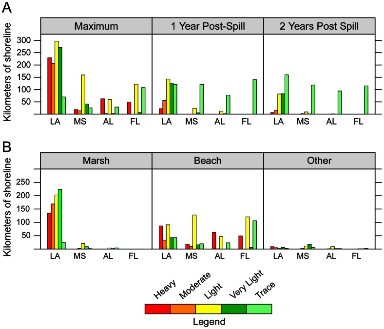
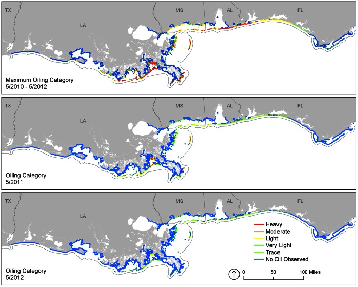
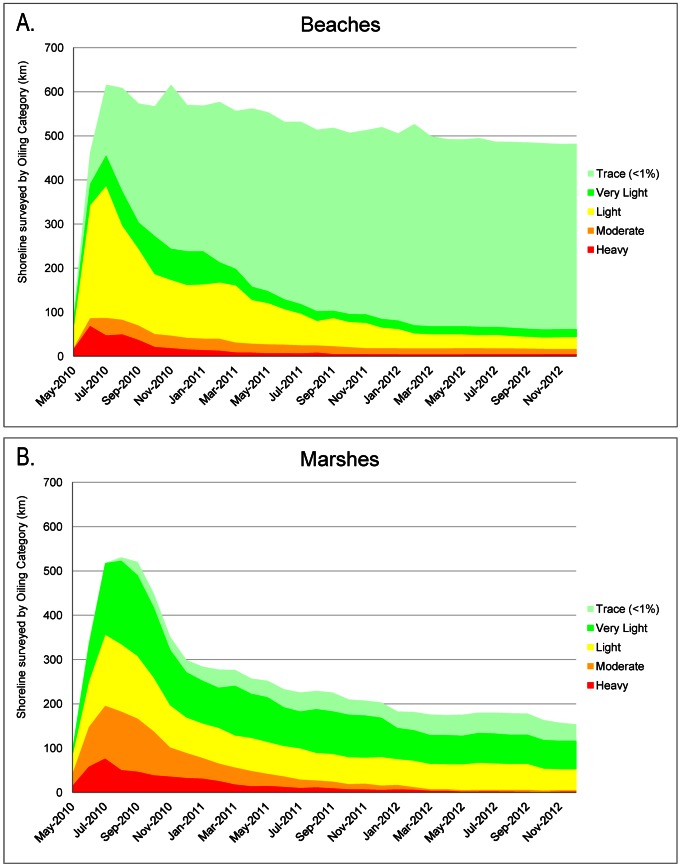
The oil from the 2010 Deepwater Horizon spill in the Gulf of Mexico was documented by shoreline assessment teams as stranding on 1,773 km of shoreline. Beaches comprised 50.8%, marshes 44.9%, and other shoreline types 4.3% of the oiled shoreline. Shoreline cleanup activities were authorized on 660 km, or 73.3% of oiled beaches and up to 71 km, or 8.9% of oiled marshes and associated habitats. One year after the spill began, oil remained on 847 km; two years later, oil remained on 687 km, though at much lesser degrees of oiling. For example, shorelines characterized as heavily oiled went from a maximum of 360 km, to 22.4 km one year later, and to 6.4 km two years later. Shoreline cleanup has been conducted to meet habitat-specific cleanup endpoints and will continue until all oiled shoreline segments meet endpoints. The entire shoreline cleanup program has been managed under the Shoreline Cleanup Assessment Technique (SCAT) Program, which is a systematic, objective, and inclusive process to collect data on shoreline oiling conditions and support decision making on appropriate cleanup methods and endpoints. It was a particularly valuable and effective process during such a complex spill.
Conflict of interest statement
Figures

References
-
- McNutt M, Camilli R, Guthrie G, Hsieh P, Labson V, et al. (2011) Assessment of flow rate estimates for the Deepwater Horizon/Macondo well oil spill. Flow rate technical group report to the national incident command, interagency solutions group, March 10, 2011. Available: http://www.doi.gov/deepwaterhorizon/loader.cfm?csModule=security/getfile.... Accessed 21 March 2013.
-
- Owens EH, Teal AR (1990) Shoreline cleanup following the Exxon Valdez oil spill: Field data collection within the S.C.A.T. program. Proceedings of the 13th Arctic and Marine Oil Spill Program Tech. Seminar, Environment Canada, Ottawa, ON, June 6–8, 1990, Edmonton, Alberta, Canada, 411–421.
-
- National Oceanic and Atmospheric Administration (2000) Shoreline Assessment Manual. Seattle: NOAA Emergency Response Division. 122 pp. Available: http://response.restoration.noaa.gov/sites/default/files/manual_shore_as.... Accessed 21 March 2013.
-
- Michel J, Benggio B (1999) Guidelines for selecting appropriate cleanup endpoints. Proceedings of the 1999 Intl. Oil Spill Conference, American Petroleum Institute, Washington, DC. Available: http://ioscproceedings.org/.
Publication types
MeSH terms
LinkOut - more resources
Full Text Sources
Other Literature Sources
Medical
