

An evaluation of the accuracy and performance of lightweight GPS collars in a suburban environment
- PMID: 23874645
- PMCID: PMC3706378
- DOI: 10.1371/journal.pone.0068496
An evaluation of the accuracy and performance of lightweight GPS collars in a suburban environment
Abstract
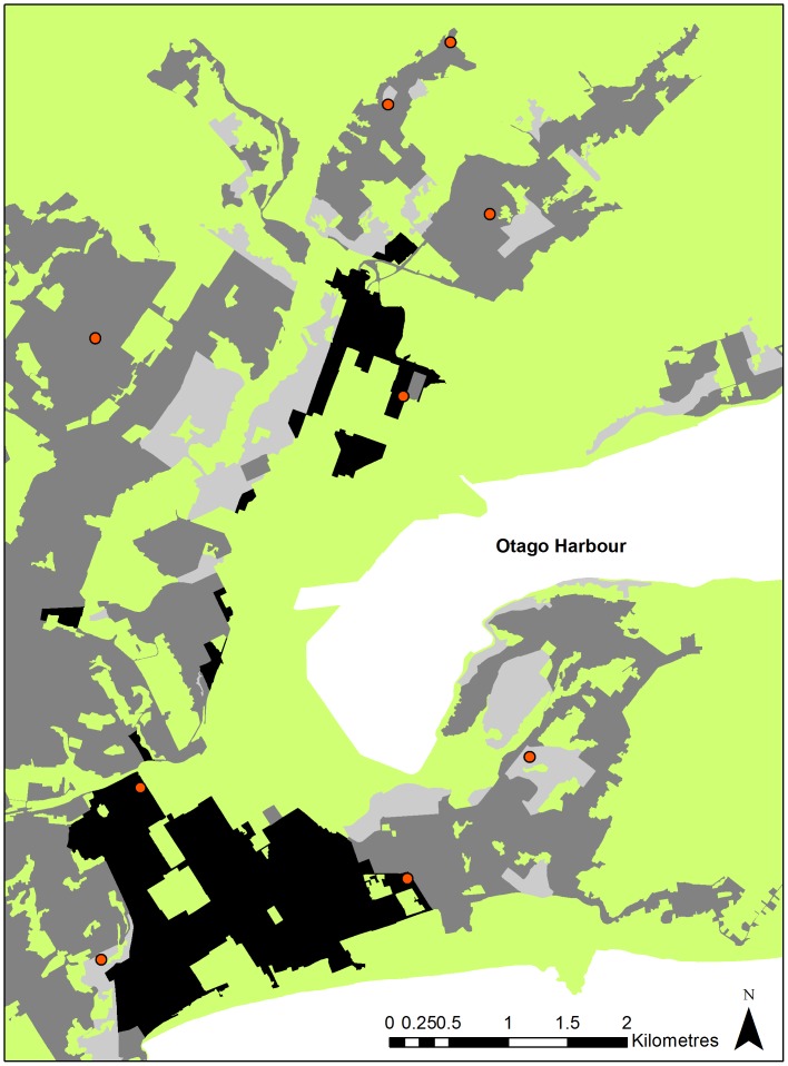
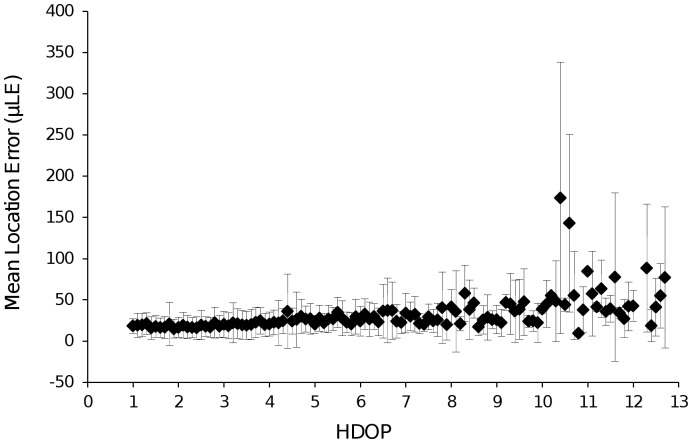
The recent development of lightweight GPS collars has enabled medium-to-small sized animals to be tracked via GPS telemetry. Evaluation of the performance and accuracy of GPS collars is largely confined to devices designed for large animals for deployment in natural environments. This study aimed to assess the performance of lightweight GPS collars within a suburban environment, which may be different from natural environments in a way that is relevant to satellite signal acquisition. We assessed the effects of vegetation complexity, sky availability (percentage of clear sky not obstructed by natural or artificial features of the environment), proximity to buildings, and satellite geometry on fix success rate (FSR) and location error (LE) for lightweight GPS collars within a suburban environment. Sky availability had the largest affect on FSR, while LE was influenced by sky availability, vegetation complexity, and HDOP (Horizontal Dilution of Precision). Despite the complexity and modified nature of suburban areas, values for FSR (mean= 90.6%) and LE (mean = 30.1 m) obtained within the suburban environment are comparable to those from previous evaluations of GPS collars designed for larger animals and within less built-up environments. Due to fine-scale patchiness of habitat within urban environments, it is recommended that resource selection methods that are not reliant on buffer sizes be utilised for selection studies.
Conflict of interest statement
Figures
References
-
- Rodgers AR (2001) Tracking animals with GPS: The first 10 years. In: Sibbald AM, Gordon IJ, editors. Tracking animals with GPS. Aberdeen, Scotland: The Macaulay Land Use Research Institute. 1–10.
-
- Rodgers AR, Rempel RS, Abraham KF (1996) A GPS-based telemetry system. Wildl. Soc. Bull. 24: 559–566.
-
- Rumble MA, Lindzey F (1997) Effects of forest vegetation and topography on global positioning system collars for elk. Resource Technol. Inst. Symp. 4: 492–501.
-
- D'Eon RG, Delparte D (2005) Effects of radio-collar position and orientation on GPS radio-collar performance, and the implications of PDOP in data screening. J. Appl. Ecol. 42: 383–388.
Publication types
MeSH terms
LinkOut - more resources
Full Text Sources
Other Literature Sources
