

Integrating spatial data and shorebird nesting locations to predict the potential future impact of global warming on coastal habitats: A case study on Farasan Islands, Saudi Arabia
- PMID: 23961191
- PMCID: PMC3730933
- DOI: 10.1016/j.sjbs.2012.02.001
Integrating spatial data and shorebird nesting locations to predict the potential future impact of global warming on coastal habitats: A case study on Farasan Islands, Saudi Arabia
Abstract
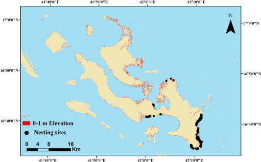
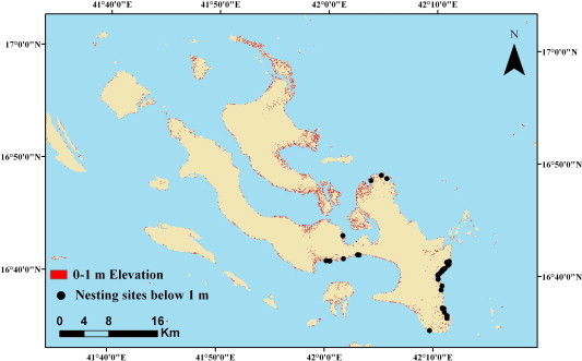
One of the expected effects of the global warming is changing coastal habitats by accelerating the rate of sea level rise. Coastal habitats support large number of marine and wetland species including shorebirds (plovers, sandpipers and allies). In this study, we investigate how coastal habitats may be impacted by sea level rise in the Farasan Islands, Kingdom of Saudi Arabia. We use Kentish plover Charadrius alexandrinus - a common coastal breeding shorebird - as an ecological model species to predict the influence of sea level rise. We found that any rise of sea level is likely to inundate 11% of Kentish plover nests. In addition, 5% of the coastal areas of Farasan Islands, which support 26% of Kentish plover nests, will be flooded, if sea level rises by one metre. Our results are constrained by the availability of data on both elevation and bird populations. Therefore, we recommend follow-up studies to model the impacts of sea level rise using different elevation scenarios, and the establishment of a monitoring programme for breeding shorebirds and seabirds in Farasan Islands to assess the impact of climate change on their populations.
Keywords: Charadrius alexandrinus; Climate change; Intertidal habitats; Kentish plover; Red Sea; Remote sensing; Sea level rise.
Figures
Similar articles
-
Anthropogenic and climate change-driven coastline dynamics will erode future nesting habitats of the kentish plover on the central adriatic coast.Sci Rep. 2024 Oct 7;14(1):23306. doi: 10.1038/s41598-024-74726-5. Sci Rep. 2024. PMID: 39375503 Free PMC article.
-
Estimating nesting habitat characteristics for the Kentish plover (Anarhynchus alexandrinus) with the effect of substrate and vegetation using a Bayesian network approach.PLoS One. 2025 Jun 11;20(6):e0325750. doi: 10.1371/journal.pone.0325750. eCollection 2025. PLoS One. 2025. PMID: 40498874 Free PMC article.
-
Mammalian predators and vegetated nesting habitat drive reduced protected area nesting success of Kentish plovers, Yellow Sea region, China.Ecol Evol. 2023 Mar 12;13(3):e9884. doi: 10.1002/ece3.9884. eCollection 2023 Mar. Ecol Evol. 2023. PMID: 36919018 Free PMC article.
-
Salinity tolerances and use of saline environments by freshwater turtles: implications of sea level rise.Biol Rev Camb Philos Soc. 2018 Aug;93(3):1634-1648. doi: 10.1111/brv.12410. Epub 2018 Mar 25. Biol Rev Camb Philos Soc. 2018. PMID: 29575680 Review.
-
Impacts of Basin-Scale Climate Modes on Coastal Sea Level: a Review.Surv Geophys. 2019;40(6):1493-1541. doi: 10.1007/s10712-019-09562-8. Epub 2019 Aug 19. Surv Geophys. 2019. PMID: 31708599 Free PMC article. Review.
Cited by
-
Use of Stable Isotopes (δ13C and δ15N) to Infer Post-Breeding Dispersal Strategies in Iberian Populations of the Kentish Plover.Animals (Basel). 2024 Apr 17;14(8):1208. doi: 10.3390/ani14081208. Animals (Basel). 2024. PMID: 38672355 Free PMC article.
-
Nesting Habitat Suitability of the Kentish Plover in the Arid Lands of Xinjiang, China.Animals (Basel). 2023 Oct 30;13(21):3369. doi: 10.3390/ani13213369. Animals (Basel). 2023. PMID: 37958123 Free PMC article.
-
Breeding biology of Saunders's tern (Sterna saundersi) in the Farasan Islands, Kingdom of Saudi Arabia.Saudi J Biol Sci. 2021 Mar;28(3):1931-1937. doi: 10.1016/j.sjbs.2020.12.044. Epub 2020 Dec 31. Saudi J Biol Sci. 2021. PMID: 33732079 Free PMC article.
-
Anthropogenic and climate change-driven coastline dynamics will erode future nesting habitats of the kentish plover on the central adriatic coast.Sci Rep. 2024 Oct 7;14(1):23306. doi: 10.1038/s41598-024-74726-5. Sci Rep. 2024. PMID: 39375503 Free PMC article.
References
-
- Aiello-Lammens M., Chu-Agor M.L., Convertino M., Fischer R.A., Linkov I., Akçakaya H.R. The impact of sea level rise on Snowy plovers in Florida: integrating geomorphological, habitat, and metapopulation models. Glob. Change Biol. 2011;17:3644–3654.
-
- AlRashidi M., Long P.R., O’Connell M., Shobrak M., Székely T. Use of remote sensing to identify suitable breeding habitat for the Kentish plover and estimate population size along the western coast of Saudi Arabia. Wader Study Group Bull. 2011;118(1):32–39.
-
- AlRashidi M., Kosztolányi A., Shobrak M., Székely T. Breeding ecology of the Kentish Plover, Charadrius alexandrinus, in the Farasan Islands, Saudi Arabia. Zool. Middle East. 2011;53:15–24.
-
- Austin G., Rehfisch M.M. The likely impact of sea level rise on waders (Charadrii) wintering on estuaries. J. Nat. Conserv. 2003;11:43–58.
-
- Baker J.D., Littnan C.L., Johnston D.W. Potential effects of sea level rise on the terrestrial habitats of endangered and endemic megafauna in the Northwestern Hawaiian Islands. Endang. Species Res. 2006;4:1–10.
LinkOut - more resources
Full Text Sources
