

Examination of how neighborhood definition influences measurements of youths' access to tobacco retailers: a methodological note on spatial misclassification
- PMID: 24148710
- PMCID: PMC3895093
- DOI: 10.1093/aje/kwt251
Examination of how neighborhood definition influences measurements of youths' access to tobacco retailers: a methodological note on spatial misclassification
Abstract
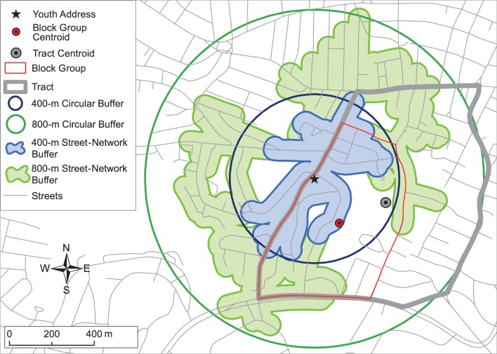
Measurements of neighborhood exposures likely vary depending on the definition of "neighborhood" selected. This study examined the extent to which neighborhood definition influences findings regarding spatial accessibility to tobacco retailers among youth. We defined spatial accessibility to tobacco retailers (i.e., tobacco retail density, closest tobacco retailer, and average distance to the closest 5 tobacco retailers) on the basis of circular and network buffers of 400 m and 800 m, census block groups, and census tracts by using residential addresses from the 2008 Boston Youth Survey Geospatial Dataset (n = 1,292). Friedman tests (to compare overall differences in neighborhood definitions) were applied. There were differences in measurements of youths' access to tobacco retailers according to the selected neighborhood definitions, and these were marked for the 2 spatial proximity measures (both P < 0.01 for all differences). For example, the median average distance to the closest 5 tobacco retailers was 381.50 m when using specific home addresses, 414.00 m when using census block groups, and 482.50 m when using census tracts, illustrating how neighborhood definition influences the measurement of spatial accessibility to tobacco retailers. These analyses suggest that, whenever possible, egocentric neighborhood definitions should be used. The use of larger administrative neighborhood definitions can bias exposure estimates for proximity measures.
Keywords: exposure science; modifiable areal unit problem; neighborhood; spatial scale; spatial zone; tobacco retailers; uncertain geographic context problem.
Figures
Comment in
-
Re: "Examination of how neighborhood definition influences measurements of youths' access to tobacco retailers: a methodological note on spatial misclassification".Am J Epidemiol. 2014 Mar 1;179(5):660-1. doi: 10.1093/aje/kwt436. Epub 2014 Jan 23. Am J Epidemiol. 2014. PMID: 24464908 No abstract available.
-
The authors reply.Am J Epidemiol. 2014 Mar 1;179(5):662. doi: 10.1093/aje/kwt437. Am J Epidemiol. 2014. PMID: 24693551 Free PMC article. No abstract available.
Similar articles
-
Re: "Examination of how neighborhood definition influences measurements of youths' access to tobacco retailers: a methodological note on spatial misclassification".Am J Epidemiol. 2014 Mar 1;179(5):660-1. doi: 10.1093/aje/kwt436. Epub 2014 Jan 23. Am J Epidemiol. 2014. PMID: 24464908 No abstract available.
-
Spatial Disparities: The Role of Nativity in Neighborhood Exposure to Alcohol and Tobacco Retailers.J Immigr Minor Health. 2022 Aug;24(4):945-955. doi: 10.1007/s10903-021-01277-6. Epub 2021 Sep 30. J Immigr Minor Health. 2022. PMID: 34591231
-
Is Smoking Cessation in Young Adults Associated With Tobacco Retailer Availability in Their Activity Space?Nicotine Tob Res. 2020 Apr 17;22(4):512-521. doi: 10.1093/ntr/nty242. Nicotine Tob Res. 2020. PMID: 30418634 Free PMC article.
-
Reducing the Density and Number of Tobacco Retailers: Policy Solutions and Legal Issues.Nicotine Tob Res. 2017 Feb;19(2):133-140. doi: 10.1093/ntr/ntw124. Epub 2016 Apr 28. Nicotine Tob Res. 2017. PMID: 27127232 Free PMC article. Review.
-
Density and Proximity of Licensed Tobacco Retailers and Adolescent Smoking.J Sch Nurs. 2017 Feb;33(1):18-29. doi: 10.1177/1059840516679710. Epub 2016 Nov 18. J Sch Nurs. 2017. PMID: 27864341 Review.
Cited by
-
Canada Post community mailboxes: implications for health research.Can J Public Health. 2014 Sep 17;105(6):e453-5. doi: 10.17269/cjph.105.4721. Can J Public Health. 2014. PMID: 25560893 Free PMC article.
-
Density of Fast Food Outlets around Educational Facilities in Riyadh, Saudi Arabia: Geospatial Analysis.Int J Environ Res Public Health. 2021 Jun 16;18(12):6502. doi: 10.3390/ijerph18126502. Int J Environ Res Public Health. 2021. PMID: 34208718 Free PMC article.
-
Built Environment Associations with Adiposity Parameters among Overweight and Obese Hispanic Youth.Prev Med Rep. 2015;2:406-412. doi: 10.1016/j.pmedr.2015.05.005. Prev Med Rep. 2015. PMID: 26339570 Free PMC article.
-
Location of Pre-exposure Prophylaxis Services Across New York City Neighborhoods: Do Neighborhood Socio-demographic Characteristics and HIV Incidence Matter?AIDS Behav. 2019 Oct;23(10):2795-2802. doi: 10.1007/s10461-019-02609-2. AIDS Behav. 2019. PMID: 31321639 Free PMC article.
-
Disadvantaged groups have greater spatial access to pharmacies in New York state.BMC Health Serv Res. 2024 Apr 15;24(1):471. doi: 10.1186/s12913-024-10901-8. BMC Health Serv Res. 2024. PMID: 38622604 Free PMC article.
References
-
- McKenzie R. The Neighborhood: A Study of Local Life in the City of Columbus, Ohio. Chicago, IL: The University of Chicago Press; 1923.
-
- Osypuk TL, Galea S. What level macro? Choosing appropriate levels to assess the relation between space and population health. In: Galea S, editor. Macrosocial Determinants of Population Health. New York, NY: Springer Media; 2007. pp. 399–436.
-
- Matthews SA. Spatial polygamy and the heterogeneity of place: studying people and place via egocentric methods. In: Burton L, Kemp SP, Leung M, et al., editors. Communities, Neighborhoods and Health: Expanding the Boundaries of Place. New York, NY: Springer; 2011. pp. 35–55.
-
- Openshaw S, Taylor P. A million or so correlation coefficients: three experiments on the modifiable area unit problem. In: Wrigley N, editor. Statistical Applications in the Spatial Sciences. London, United Kingdom: Pio Ltd; 1979. pp. 127–144.
-
- Arbia G. Spatial Data Configuration in the Statistical Analysis of Regional Economics and Related Problems. Kluwer: Dordrecht, the Netherlands; 1989.
Publication types
MeSH terms
Grants and funding
LinkOut - more resources
Full Text Sources
Other Literature Sources
