Elevated rates of gold mining in the Amazon revealed through high-resolution monitoring
- PMID: 24167281
- PMCID: PMC3832012
- DOI: 10.1073/pnas.1318271110
Elevated rates of gold mining in the Amazon revealed through high-resolution monitoring
Abstract
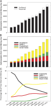
Gold mining has rapidly increased in western Amazonia, but the rates and ecological impacts of mining remain poorly known and potentially underestimated. We combined field surveys, airborne mapping, and high-resolution satellite imaging to assess road- and river-based gold mining in the Madre de Dios region of the Peruvian Amazon from 1999 to 2012. In this period, the geographic extent of gold mining increased 400%. The average annual rate of forest loss as a result of gold mining tripled in 2008 following the global economic recession, closely associated with increased gold prices. Small clandestine operations now comprise more than half of all gold mining activities throughout the region. These rates of gold mining are far higher than previous estimates that were based on traditional satellite mapping techniques. Our results prove that gold mining is growing more rapidly than previously thought, and that high-resolution monitoring approaches are required to accurately quantify human impacts on tropical forests.
Keywords: CLASlite; Carnegie Airborne Observatory; Peru; deforestation; forest degradation.
Conflict of interest statement
The authors declare no conflict of interest.
Figures


References
-
- Hemming J. Tree of Rivers: The History of the Amazon. London: Thames & Hudson; 2008.
-
- Cleary D. Anatomy of the Amazon Gold Rush. London: Palgrave Macmillan; 1990. p. 287.
-
- Shafiee S, Topal E. An overview of global gold market and gold price forecasting. Resour Policy. 2010;35(3):178–189.
-
- Brooks WE, Sandoval E, Yepez MA, Howard H. Peru Mercury Inventory 2006. Reston, VA: US Geological Survey; 2007. p. 55.
Publication types
MeSH terms
Substances
LinkOut - more resources
Full Text Sources
Other Literature Sources

