. 2013 Aug 30:1:28.
doi: 10.3389/fpubh.2013.00028. eCollection 2013.

Mapping avian influenza transmission risk at the interface of domestic poultry and wild birds

Affiliations

Mapping avian influenza transmission risk at the interface of domestic poultry and wild birds

Diann J Prosser et al. Front Public Health. .

Abstract

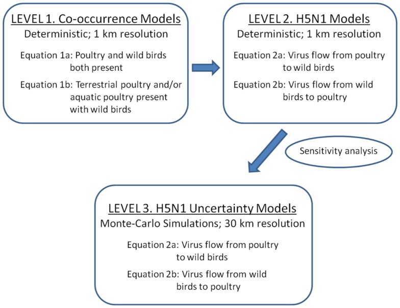
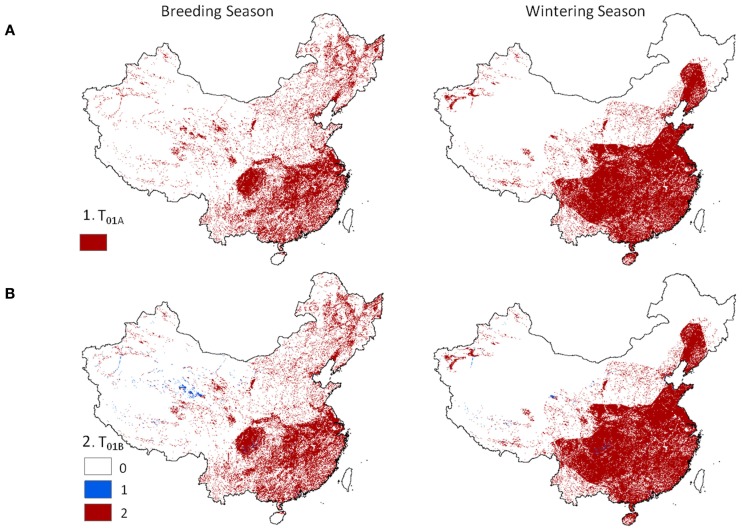
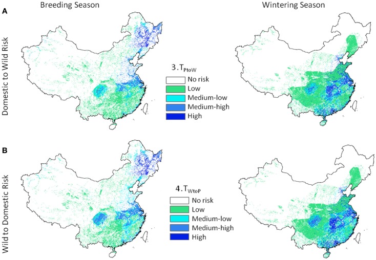
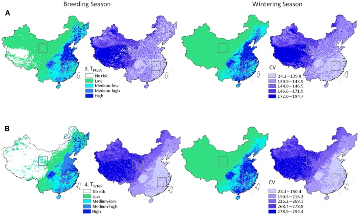
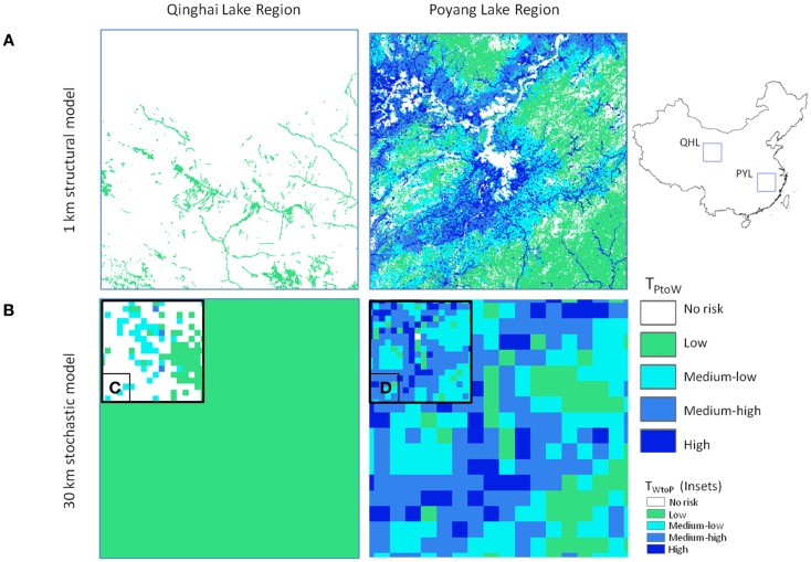
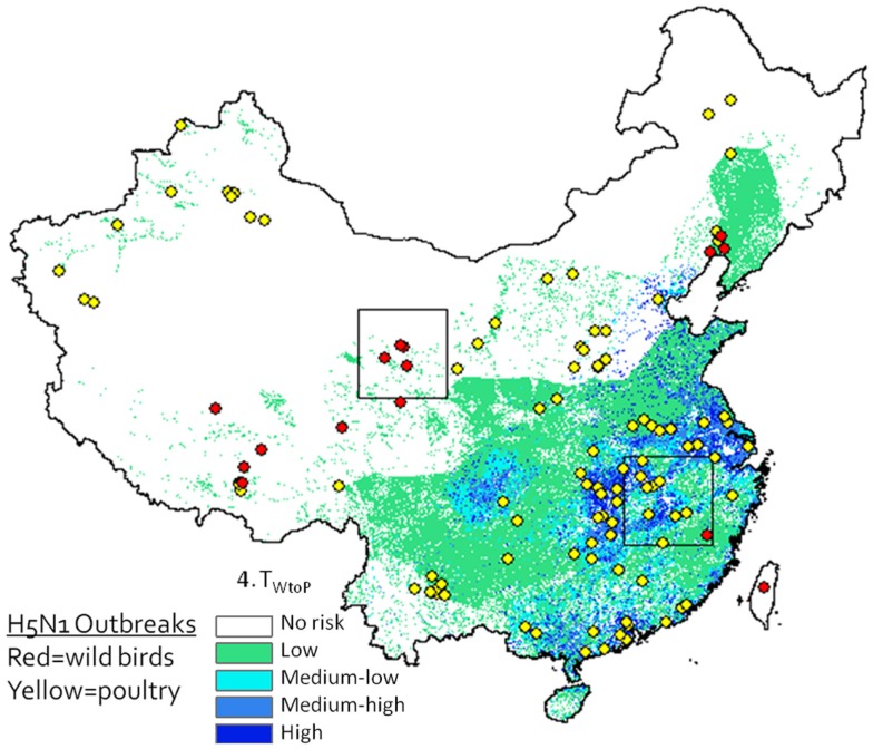
Emergence of avian influenza viruses with high lethality to humans, such as the currently circulating highly pathogenic A(H5N1) (emerged in 1996) and A(H7N9) cause serious concern for the global economic and public health sectors. Understanding the spatial and temporal interface between wild and domestic populations, from which these viruses emerge, is fundamental to taking action. This information, however, is rarely considered in influenza risk models, partly due to a lack of data. We aim to identify areas of high transmission risk between domestic poultry and wild waterfowl in China, the epicenter of both viruses. Two levels of models were developed: one that predicts hotspots of novel virus emergence between domestic and wild birds, and one that incorporates H5N1 risk factors, for which input data exists. Models were produced at 1 and 30 km spatial resolution, and two temporal seasons. Patterns of risk varied between seasons with higher risk in the northeast, central-east, and western regions of China during spring and summer, and in the central and southeastern regions during winter. Monte-Carlo uncertainty analyses indicated varying levels of model confidence, with lowest errors in the densely populated regions of eastern and southern China. Applications and limitations of the models are discussed within.

Keywords: China; H5N1; Monte-Carlo; avian influenza; poultry; spatial modeling; uncertainty; waterfowl.


Figures

Figure 1
Figure 1
Three levels of spatial models implemented for assessing H5N1 transmission risk between wild and domestic birds in China. Level 1 and 2 deterministic models were developed to refine the transmission equations (1 km resolution). Level 1 models are co-occurrence models that predict where wild and domestic birds may come in contact. Level 2 models incorporate uni-directional equations for H5N1 transmission risk between poultry and wild birds. Level 3 models incorporate uncertainty using Monte-Carlo simulations at 30 km resolution.
Figure 2
Figure 2
Hotspot regions of potential disease transmission between domestic and wild birds in China. Models are 1 km resolution co-occurrence for China’s domestic poultry and wild Anatidae waterfowl: (A) domestic poultry and wild Anatidae are predicted present (Eq. 1), and (B) terrestrial and aquatic poultry are predicted present in combination with wild Anatidae (red) versus presence of one poultry group (blue) with wild Anatidae (Eq. 2).
Figure 3
Figure 3
Highly pathogenic H5N1 transmission risk between domestic poultry and wild Anatidae waterfowl at 1 km resolution for China. Level 2 models include H5N1-specific transmission factors and are uni-directional with (A) representing transmission risk from domestic to wild birds (Eq. 3), and (B) from wild birds to domestic (Eq. 4).
Figure 4
Figure 4
H5N1 transmission risk between wild and domestic birds in China and associated uncertainty predictions at 30 km resolution. Risk maps represented as mean and CV (left and right in each pair of maps, respectively). (A) Top panel represents transmission risk from poultry to wild waterfowl; (B) bottom panel represents transmission risk from wild waterfowl to poultry. Maps are symbolized using quantiles. Black boxes correspond to the Qinghai Lake and Poyang Lake Regions outlined in Figure 5.
Figure 5
Figure 5
Comparison of model outputs for Qinghai Lake (QHL) and Poyang Lake (PYL) sub-regions for (A) 1 km deterministic and (B) 30 km Monte-Carlo model outputs using Eq. 3 (poultry to wild transmission risk) for the winter season. Insets (C,D) show comparisons for the breeding season Eq. 4 (wild to poultry transmission).
Figure 6
Figure 6
H5N1 outbreak data (2003–2009) plotted against Level 2 deterministic 1 km resolution H5N1 transmission risk models (Eq. 4). Wild bird cases shown by red circles, poultry by yellow circles. Although spatial associations between outbreak data and risk map appear to be high, since the model is intended to predict risk at the interface between poultry and waterfowl, this type of presentation may be misleading as it is not known whether yellow dots represent poultry cases caused by transmission from wild birds (versus poultry) and whether red dots represent wild bird cases caused by poultry (versus wild birds).

Similar articles

Cited by

References

    1. Taylor LH, Latham SM, Woolhouse MEJ. Risk factors for human disease emergence. Philos Trans R Soc Lond B Biol Sci (2001) 356(1411):983–910.1098/rstb.2001.0888 - DOI - PMC - PubMed
    1. Alexander DJ. An overview of the epidemiology of avian influenza. Vaccine (2007) 25(30):5637–4410.1016/j.vaccine.2006.10.051 - DOI - PubMed
    1. Delgado C. Rising consumption of meat and milk in developing countries has created a new food revolution. J Nutr (2003) 133(11):3907S–10 - PubMed
    1. Daszak P, Cunningham AA, Hyatt AD. Wildlife ecology – emerging infectious diseases of wildlife – threats to biodiversity and human health. Science (2000) 287(5452):443–910.1126/science.287.5452.443 - DOI - PubMed
    1. Brown C. Emerging zoonoses and pathogens of public health significance – an overview. Rev Sci Tech (2004) 23(2):435–42 - PubMed

LinkOut - more resources