

Participatory Risk Mapping of Malaria Vector Exposure in Northern South America using Environmental and Population Data
- PMID: 24976656
- PMCID: PMC4066217
- DOI: 10.1016/j.apgeog.2014.01.002
Participatory Risk Mapping of Malaria Vector Exposure in Northern South America using Environmental and Population Data
Abstract
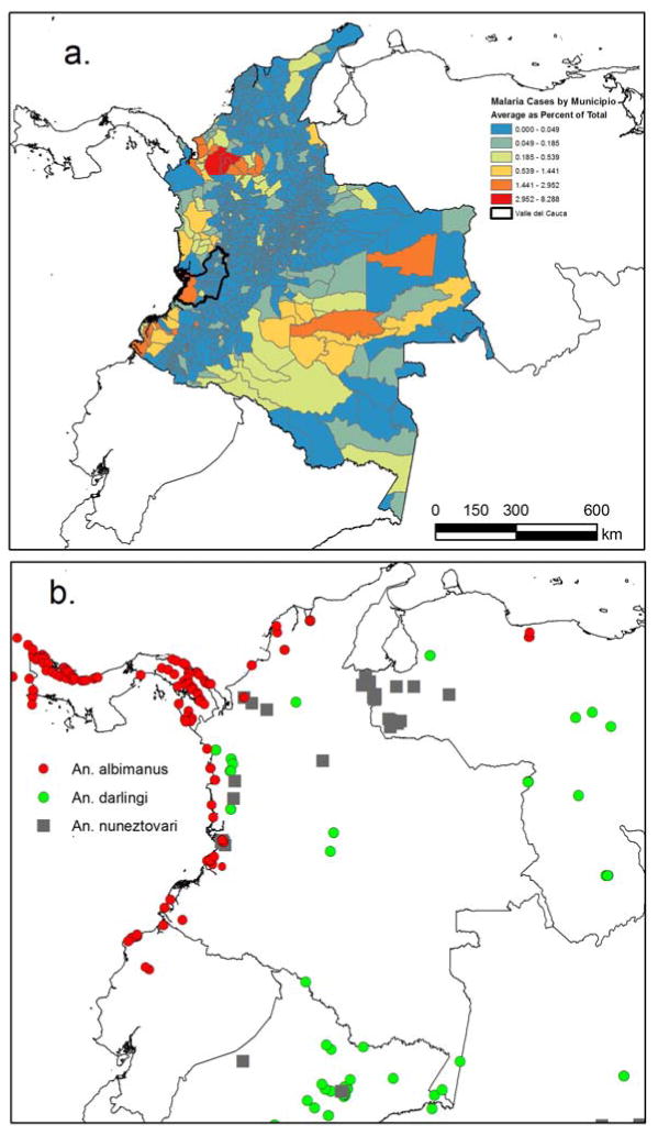
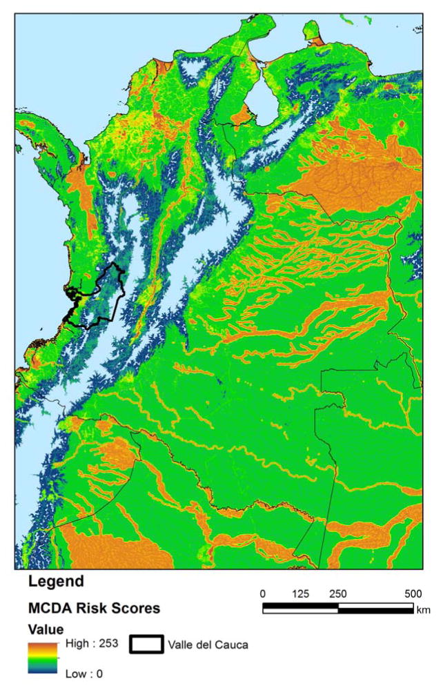
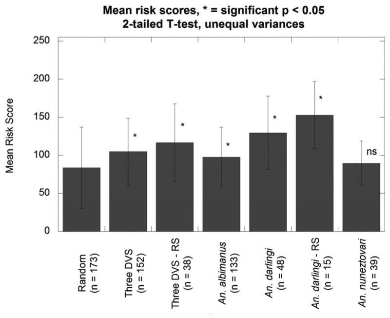
Malaria elimination remains a major public health challenge in many tropical regions, including large areas of northern South America. In this study, we present a new high spatial resolution (90 × 90 m) risk map for Colombia and surrounding areas based on environmental and human population data. The map was created through a participatory multi-criteria decision analysis in which expert opinion was solicited to determine key environmental and population risk factors, different fuzzy functions to standardize risk factor inputs, and variable factor weights to combine risk factors in a geographic information system. The new risk map was compared to a map of malaria cases in which cases were aggregated to the municipio (municipality) level. The relationship between mean municipio risk scores and total cases by muncípio showed a weak correlation. However, the relationship between pixel-level risk scores and vector occurrence points for two dominant vector species, Anopheles albimanus and An. darlingi, was significantly different (p < 0.05) from a random point distribution, as was a pooled point distribution for these two vector species and An. nuneztovari. Thus, we conclude that the new risk map derived based on expert opinion provides an accurate spatial representation of risk of potential vector exposure rather than malaria transmission as shown by the pattern of malaria cases, and therefore it may be used to inform public health authorities as to where vector control measures should be prioritized to limit human-vector contact in future malaria outbreaks.
Keywords: Anopheles species; Participatory GIS; malaria; multi-criteria decision analysis; risk mapping.
Figures

Similar articles
-
A multi-criteria decision analysis approach to assessing malaria risk in northern South America.BMC Public Health. 2016 Mar 3;16:221. doi: 10.1186/s12889-016-2902-7. BMC Public Health. 2016. PMID: 26940004 Free PMC article.
-
Spatial association between malaria vector species richness and malaria in Colombia.Acta Trop. 2016 Jun;158:197-200. doi: 10.1016/j.actatropica.2016.03.008. Epub 2016 Mar 9. Acta Trop. 2016. PMID: 26970373
-
Entomological characterization of malaria in northern Colombia through vector and parasite species identification, and analyses of spatial distribution and infection rates.Malar J. 2017 Oct 27;16(1):431. doi: 10.1186/s12936-017-2076-5. Malar J. 2017. PMID: 29078770 Free PMC article.
-
Ecology of Anopheles darlingi Root with respect to vector importance: a review.Parasit Vectors. 2011 Sep 16;4:177. doi: 10.1186/1756-3305-4-177. Parasit Vectors. 2011. PMID: 21923902 Free PMC article. Review.
-
Malaria entomological profile in Tanzania from 1950 to 2010: a review of mosquito distribution, vectorial capacity and insecticide resistance.Tanzan J Health Res. 2011 Dec;13(5 Suppl 1):319-31. Tanzan J Health Res. 2011. PMID: 26591987 Review.
Cited by
-
Malaria Risk Map Using Spatial Multi-Criteria Decision Analysis along Yunnan Border During the Pre-elimination Period.Am J Trop Med Hyg. 2020 Aug;103(2):793-809. doi: 10.4269/ajtmh.19-0854. Epub 2020 Jun 25. Am J Trop Med Hyg. 2020. PMID: 32602435 Free PMC article.
-
Mapping and Modelling Malaria Risk Areas Using Climate, Socio-Demographic and Clinical Variables in Chimoio, Mozambique.Int J Environ Res Public Health. 2018 Apr 19;15(4):795. doi: 10.3390/ijerph15040795. Int J Environ Res Public Health. 2018. PMID: 29671756 Free PMC article.
-
Patterns and Determinants of Imported Malaria near the Argentina-Bolivia Border, 1977-2009.Pathogens. 2025 May 28;14(6):537. doi: 10.3390/pathogens14060537. Pathogens. 2025. PMID: 40559545 Free PMC article.
-
Participatory mapping identifies risk areas and environmental predictors of endemic anthrax in rural Africa.Sci Rep. 2022 Jun 22;12(1):10514. doi: 10.1038/s41598-022-14081-5. Sci Rep. 2022. PMID: 35732674 Free PMC article.
-
Prospects and recommendations for risk mapping to improve strategies for effective malaria vector control interventions in Latin America.Malar J. 2015 Dec 23;14:519. doi: 10.1186/s12936-015-1052-1. Malar J. 2015. PMID: 26694047 Free PMC article. Review.
References
-
- da Silva-Nunes M, Moreno M, Conn JE, Gamboa D, Abeles S, Vinetz JM, Ferreira MU. Amazonian malaria: Asymptomatic human reservoirs, diagnostic challenges, environmentally driven changes in mosquito vector populations, and the mandate for sustainable control strategies. Acta Tropica. 2012;121:281–291. - PMC - PubMed
-
- Eastman RE. IDRISI 17: The Selva Edition. Clark Labs. Clark Labs, Clark University; Worcester, MA, USA: 2012.
Grants and funding
LinkOut - more resources
Full Text Sources
Other Literature Sources