. 2014 Jul 7:4:5589.
doi: 10.1038/srep05589.

Environmental variability and biodiversity of megabenthos on the Hebrides Terrace Seamount (Northeast Atlantic)

Affiliations

Environmental variability and biodiversity of megabenthos on the Hebrides Terrace Seamount (Northeast Atlantic)

Lea-Anne Henry et al. Sci Rep. .

Abstract

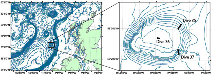
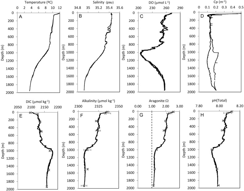
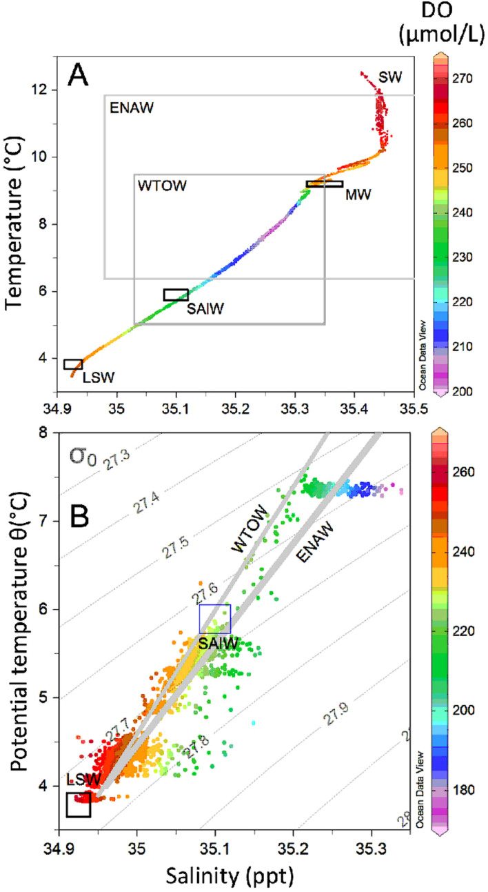
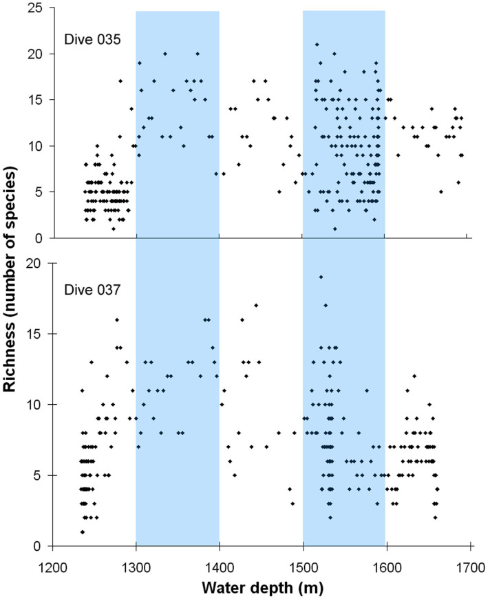
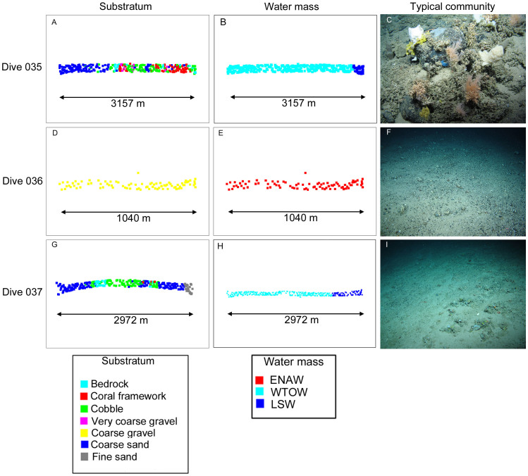
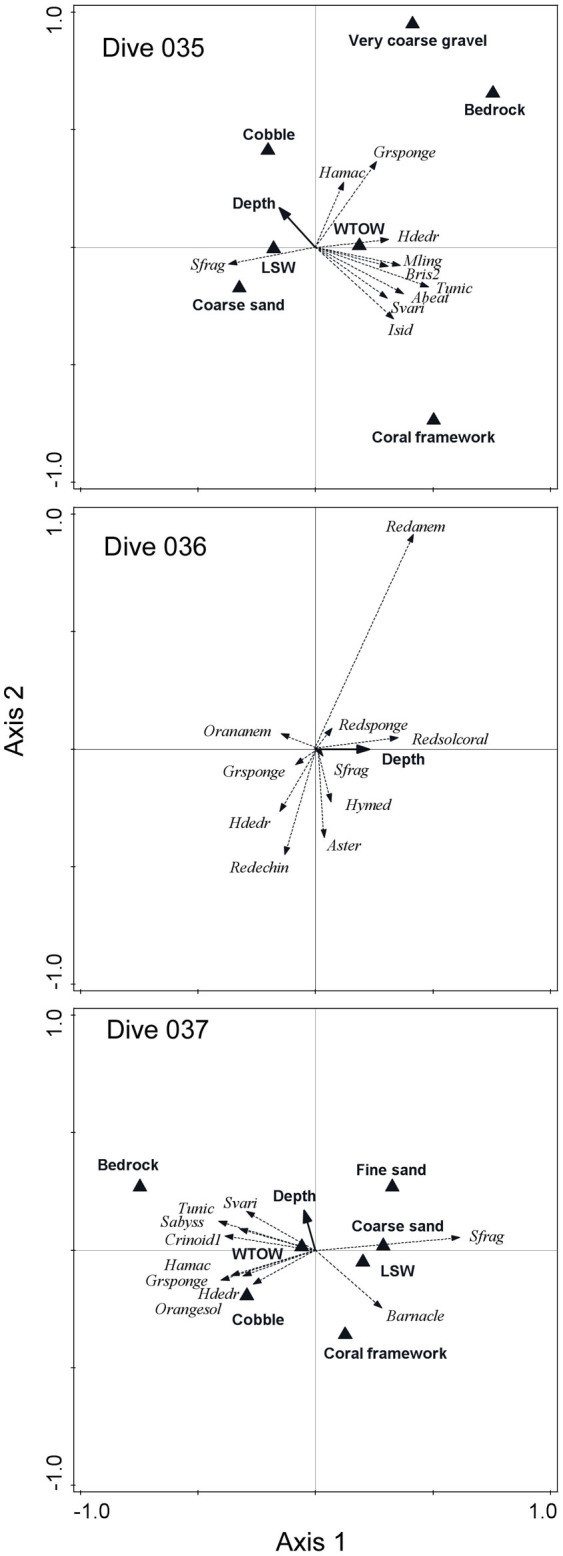
We present the first remotely operated vehicle investigation of megabenthic communities (1004-1695 m water depth) on the Hebrides Terrace Seamount (Northeast Atlantic). Conductivity-temperature-depth casts showed rapid light attenuation below the summit and an oceanographic regime on the flanks consistent with an internal tide, and high short-term variability in water temperature, salinity, light attenuation, aragonite and oxygen down to 1500 m deep. Minor changes in species composition (3-14%) were explained by changes in depth, substratum and oceanographic stability, whereas environmental variability explained substantially more variation in species richness (40-56%). Two peaks in species richness occurred, the first at 1300-1400 m where cooler Wyville Thomson Overflow Water (WTOW) mixes with subtropical gyre waters and the second at 1500-1600 m where WTOW mixes with subpolar mode waters. Our results suggest that internal tides, substrate heterogeneity and oceanographic interfaces may enhance biological diversity on this and adjacent seamounts in the Rockall Trough.


Figures

Figure 1
Figure 1. Location of the Hebrides Terrace Seamount in the southcentral Rockall Trough and the three ROV dive transects on the seamount summit and flanks (inset).
Maps were generated using ArcGIS version 9.3.
Figure 2
Figure 2
Depth profiles from the full CTD cast (0–1930 m water depth), showing measured (A): temperature (°C), (B): salinity (psu), (C): dissolved oxygen concentration (DO), (D): particle attenuation coefficient (Cp), (E): dissolved inorganic carbon (DIC), (F): total alkalinity (TA), and calculated (G): aragonite saturation state, and (H): pH (total scale). In figures (E–H) black crosses indicate the mean value of the data collected from water samples (error bars are 1 standard deviation).
Figure 3
Figure 3. Water mass properties at the HTS.
(A): T-S and DO conditions encountered on the HTS through a vertical profile from the surface to 1930 m. (B): T-S and DO conditions for the ROV dives 035, 036 and 037 with density (σ) contours. Water mass indicators for SW, (surface waters), ENAW (Eastern North Atlantic Water), WTOW (Wyville Thomson Ridge Overflow Water), MW (Mediterranean Waters), SAIW (Sub-Arctic Intermediate Water) and LSW (Labrador Seawater) properties are shown as either boxes or mixing-lines. Representative values for water masses were taken from McGrath et al. for the Rockall Trough.
Figure 4
Figure 4. Depth-related trends in species richness per image during dives 035 and 037.
Blue bars indicate what appear to be peaks in species richness.
Figure 5
Figure 5. Spatial gradients in sedimentary facies and water mass structure and the length of each dive transect in a non-metric multidimensional scaling plot.
A representative benthic community image is shown in each case using selected ROV images obtained by the authors during the JC073 cruise.
Figure 6
Figure 6. Species-environment biplots from the flanks (dives 035 and 037) and summit (dive 036) showing the species that were most strongly correlated to the ordination axes.
Abbreviations are as follows: Sfrag = Syringammina fragilissima; Isid = cf Isidella indeterminate species; Svari = Solenosmilia variabilis; Abeat = Aprocallistes beatrix; Tunic = Tunicata; Bris2 = Brisingiid sp. 2; Mling = Mycale lingua; Hdedr = Hexadella dedritifera; Grsponge = green encrusting sponge; Hamac = ?Hamacantha indeterminate sp.; Redanem = red anemone sp.; Redsponge = red sponge sp.; Redsolcoral = red solitary coral; Orananem = orange anemone sp.; Hymed = Hymesdesmia cf (Hymedesmia) curvichela; Aster = asteroid sp. 1; Redechin = red echinoid sp.; Barnacle = barnacle; Orangesol = orange solitary coral; Crinoid1 = crinoid sp. 1; Sabyss = Stichopathes cf abyssicola.

References

    1. Clark M. R. et al. The ecology of seamounts: structure, function, and human impacts. Annu. Rev. Mar. Sci. 2, 253–278 (2010). - PubMed
    1. Clark M. R., Schlacher T. A., Rowden A. A., Stocks K. I. & Consalvey M. Science priorities for seamounts: research links to conservation and management. PLoS One 7, e29232 (2012). - PMC - PubMed
    1. Althaus F. et al. Impacts of bottom trawling on deep-coral ecosystems of seamounts are long-lasting. Mar. Ecol. Prog. Ser. 397, 279–294 (2009).
    1. McClain C. R., Lundsten L., Barry J. & DeVogelaere A. Assemblage structure, but not diversity or density, change with depth on a northeast Pacific seamount. Mar. Ecol. 31 (Suppl. S1), 14–25 (2010).
    1. Williams A. et al. Scales of habitat heterogeneity and megabenthos biodiversity on an extensive Australian continental margin (100–1000 m depths). Mar. Ecol. 31, 222–236 (2010).

Publication types

LinkOut - more resources