

A Review and Framework for Categorizing Current Research and Development in Health Related Geographical Information Systems (GIS) Studies
- PMID: 25123730
- PMCID: PMC4287070
- DOI: 10.15265/IY-2014-0008
A Review and Framework for Categorizing Current Research and Development in Health Related Geographical Information Systems (GIS) Studies
Abstract
Objectives: The application of GIS in health science has increased over the last decade and new innovative application areas have emerged. This study reviews the literature and builds a framework to provide a conceptual overview of the domain, and to promote strategic planning for further research of GIS in health.
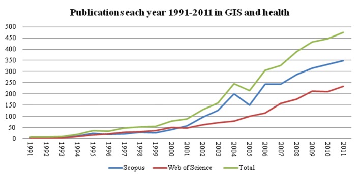
Method: The framework is based on literature from the library databases Scopus and Web of Science. The articles were identified based on keywords and initially selected for further study based on titles and abstracts. A grounded theory-inspired method was applied to categorize the selected articles in main focus areas. Subsequent frequency analysis was performed on the identified articles in areas of infectious and non-infectious diseases and continent of origin.
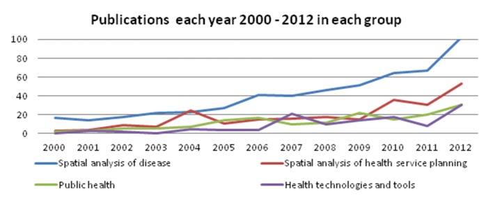
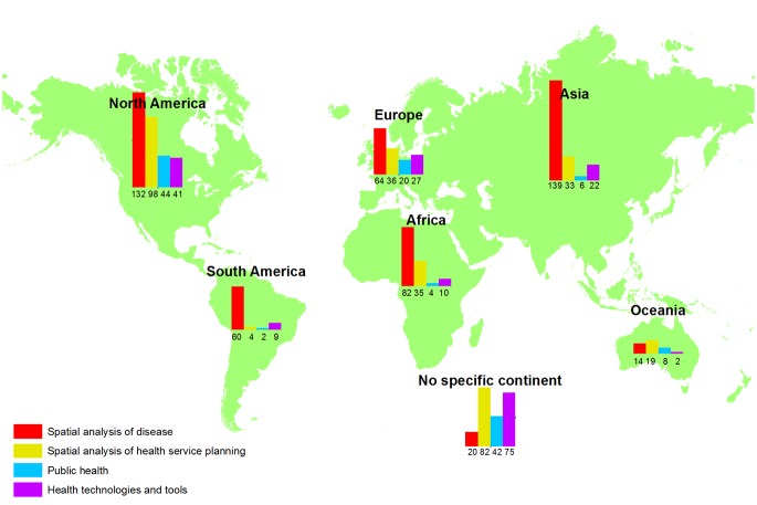
Results: A total of 865 articles were included. Four conceptual domains within GIS in health sciences comprise the framework: spatial analysis of disease, spatial analysis of health service planning, public health, health technologies and tools. Frequency analysis by disease status and location show that malaria and schistosomiasis are the most commonly analyzed infectious diseases where cancer and asthma are the most frequently analyzed non-infectious diseases. Across categories, articles from North America predominate, and in the category of spatial analysis of diseases an equal number of studies concern Asia.
Conclusion: Spatial analysis of diseases and health service planning are well-established research areas. The development of future technologies and new application areas for GIS and data-gathering technologies such as GPS, smartphones, remote sensing etc. will be nudging the research in GIS and health.
Keywords: Epidemiology; cluster analysis; geographic information system; public health; spatial analysis.
Figures
References
-
- Hipocrates, Clifton F, Watts J.Hippocrates upon air, water, and situation: upon epidemical diseases; and upon prognosticks, in acute cases especially. To this is added (by way of comparison) Thucydides’s account of the plague of Athens, the whole translated, methodis’d, and illustrated with useful and explanatory notes. London; Printed for J. Watts; 1734. 389 p.
-
- Barrett FA. Finke’s 1792 map of human diseases: The first world disease map? Soc Sci Med. 2000;50(7-8):915–21. - PubMed
-
- Koch T.Disease Maps: Epidemics on the Ground. Chicago: University of Chicago Press; 2011.
-
- Snow J.On the mode of communication of cholera. London: John Churchill; 1855.
Publication types
MeSH terms
LinkOut - more resources
Full Text Sources
Other Literature Sources