

Nonfatal injuries 1 week after hurricane sandy--New York city metropolitan area, October 2012
- PMID: 25340912
- PMCID: PMC5779470
Nonfatal injuries 1 week after hurricane sandy--New York city metropolitan area, October 2012
Abstract
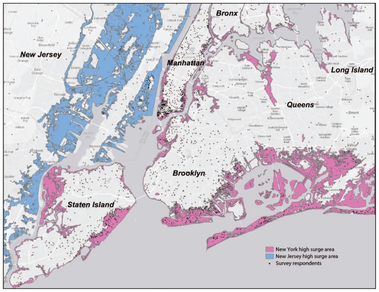
On October 29, 2012, Hurricane Sandy (Sandy) made landfall in densely populated areas of New York, New Jersey, and Connecticut. Flooding affected 51 square miles (132 square kilometers) of New York City (NYC) and resulted in 43 deaths, many caused by drowning in the home, along with numerous storm-related injuries. Thousands of those affected were survivors of the World Trade Center (WTC) disaster of September 11, 2001 (9/11) who had previously enrolled in the WTC Health Registry (Registry) cohort study. To assess Sandy-related injuries and associated risk factors among those who lived in Hurricane Sandy-flooded areas and elsewhere, the NYC Department of Health and Mental Hygiene surveyed 8,870 WTC survivors, who had provided physical and mental health updates 8 to 16 months before Sandy. Approximately 10% of the respondents in flooded areas reported injuries in the first week after Sandy; nearly 75% of those had more than one injury. Injuries occurred during evacuation and clean-up/repair of damaged or destroyed homes. Hurricane preparation and precautionary messages emphasizing potential for injury hazards during both evacuation and clean-up or repair of damaged residences might help mitigate the occurrence and severity of injury after a hurricane.
Figures
Similar articles
-
Exposure to multiple disasters: The long-term effect of Hurricane Sandy (October 29, 2012) on NYC survivors of the September 11, 2001 World Trade Center attack.Psychiatry Res. 2019 Mar;273:719-724. doi: 10.1016/j.psychres.2019.01.090. Epub 2019 Jan 29. Psychiatry Res. 2019. PMID: 31207858
-
Hurricane Sandy Evacuation Among World Trade Center Health Registry Enrollees in New York City.Disaster Med Public Health Prep. 2016 Jun;10(3):411-9. doi: 10.1017/dmp.2016.57. Epub 2016 Apr 21. Disaster Med Public Health Prep. 2016. PMID: 27098725
-
Injury Deaths Related to Hurricane Sandy, New York City, 2012.Disaster Med Public Health Prep. 2016 Jun;10(3):378-85. doi: 10.1017/dmp.2016.36. Epub 2016 Apr 13. Disaster Med Public Health Prep. 2016. PMID: 27074115
-
Immediate Injury Deaths Related to the Remnants From Hurricane Ida in New York City, September 1-2, 2021.Disaster Med Public Health Prep. 2024 Apr 5;18:e55. doi: 10.1017/dmp.2024.49. Disaster Med Public Health Prep. 2024. PMID: 38577778 Review.
-
Poisonings After a Hurricane: Lessons From the New Jersey Poison Information and Education System (NJPIES) During and Following Hurricane Sandy.Disaster Med Public Health Prep. 2022 Feb;16(1):5-7. doi: 10.1017/dmp.2020.201. Epub 2020 Sep 1. Disaster Med Public Health Prep. 2022. PMID: 32867868 Review.
Cited by
-
The trauma signature of 2016 Hurricane Matthew and the psychosocial impact on Haiti.Disaster Health. 2016 Nov 28;3(4):121-138. doi: 10.1080/21665044.2016.1263538. eCollection 2016. Disaster Health. 2016. PMID: 28321360 Free PMC article.
-
Perceptions of severe storms, climate change, ecological structures and resiliency three years post-hurricane Sandy in New Jersey.Urban Ecosyst. 2017 Dec;20(6):1261-1275. doi: 10.1007/s11252-017-0678-x. Epub 2017 May 17. Urban Ecosyst. 2017. PMID: 29398897 Free PMC article.
-
Re-experiencing 9/11-Related PTSD Symptoms Following Exposure to Hurricane Sandy.Int J Emerg Ment Health. 2018;20(3):10.4172/1522-4821.1000404. doi: 10.4172/1522-4821.1000404. Int J Emerg Ment Health. 2018. PMID: 30245592 Free PMC article.
-
Comparison of Simulated Treatment and Cost-effectiveness of a Stepped Care Case-Finding Intervention vs Usual Care for Posttraumatic Stress Disorder After a Natural Disaster.JAMA Psychiatry. 2017 Dec 1;74(12):1251-1258. doi: 10.1001/jamapsychiatry.2017.3037. JAMA Psychiatry. 2017. PMID: 28979968 Free PMC article.
-
Aging in Flood-Prone Coastal Areas: Discerning the Health and Well-Being Risk for Older Residents.Int J Environ Res Public Health. 2018 Dec 18;15(12):2900. doi: 10.3390/ijerph15122900. Int J Environ Res Public Health. 2018. PMID: 30567352 Free PMC article.
References
-
- NYC Special Initiative for Rebuilding and Resiliency. A stronger, more resilient New York. New York, NY: NYC Special Initiative for Rebuilding and Resiliency, City of New York; 2013. Available at http://www.nyc.gov/html/sirr/html/report/report.shtml.
-
- Federal Emergency Management Agency Modeling Task Force. FEMA MOTF-Hurricane Sandy impact analysis. Washington, DC: US Department of Homeland Security, Federal Emergency Management; 2014. Available at http://www.arcgis.com/home/item.html?id=307dd522499d4a44a33d7296a5da5ea0.
-
- Testimony of Caswell F. Holloway, Deputy Mayor for Operations, City of New York, before the Subcommittee on Emergency Management, Intergovernmental Relations, and the District of Columbia of the U.S. Senate Committee on Homeland Security and Governmental Affairs (November 6, 2013) Available at http://www.hsgac.senate.gov/download/?id=c9ca4629-9a89-481d-a218-34dbbb5....
-
- Gibbs L, Holloway C. NYC Hurricane Sandy after action report: report and recommendations to Mayor Michael R. Bloomberg. New York, NY: City of New York; 2013. Available at http://www.nyc.gov/html/recovery/downloads/pdf/sandy_aar_5.2.13.pdf.
-
- CDC. Surveillance for illness and injury after Hurricane Katrina—New Orleans, Louisiana, September 8–25, 2005. MMWR. 2005;54:1018–21. - PubMed
MeSH terms
Grants and funding
LinkOut - more resources
Full Text Sources
Medical
