

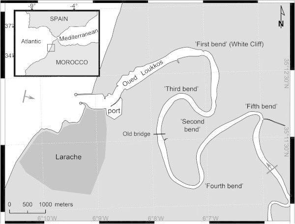
Spatial-temporal distribution of salinity and temperature in the Oued Loukkos estuary, Morocco: using vertical salinity gradient for estuary classification
- PMID: 25485187
- PMCID: PMC4233025
- DOI: 10.1186/2193-1801-3-643
Spatial-temporal distribution of salinity and temperature in the Oued Loukkos estuary, Morocco: using vertical salinity gradient for estuary classification
Abstract
Background: Several different classifications to characterize estuarine systems have been proposed. In this present paper, one of the most important estuaries in North Africa, the Oued Loukkos (Morocco), forms a case-study for proposing a systematic classification of this particular tidal estuary according to the vertical salinity gradient.
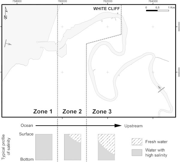
Findings: This study, conducted using a CTD, shows that the spatial-temporal distribution of salinity depends on the stage of the tide and the upstream distance from the mouth of the river. In this case, it is also evident that the morphology of the bottom was capable of impacting the distribution of salinity by locally changing the water circulation.
Conclusions: Based on the vertical salinity gradient measurement, the Oued Loukkos represents an estuarine environment with one section near its mouth that can be characterized as a mixed mesotidal estuary and another section upstream which can be characterized as a stratified mesotidal estuary. Between, there is an intermediate zone with a low vertical gradient of salinity, classified as a partially mixed mesotidal estuary. When the effect of terrestrial inputs is low compared to marine inputs, the river bed topography plays a role in the stratification of salinity by either disrupting the vertical stratification of the water or by changing the lateral distribution of salinity. The proposed classification deepens our hydrological knowledge and provides descriptive labels to the Oued Loukkos estuary. It provides a valid starting point for predicting the environmental impact of future recreational, agricultural and commercial activities on the estuary.
Keywords: Characteristics of salinity; Estuary classification; Morocco; Oued Loukkos; Stage of tide.
Figures


References
-
- Allen JRL. An introduction to estuarine lithosomes and their controls. Sediment Rev. 1993;1:123–138. doi: 10.1002/9781444304534.ch8. - DOI
-
- Aloussi L. Evolution spatio-temporelle de l’estuaire du Loukkos; étude préliminaire. MémoireDESA. Rabat: Faculté des Sciences; 2008.
-
- Bazairi H, Gam M, Kalloul S, Zourarah B. Caractérisation bio-géologique des habitats benthiques d’un écosystème côtier de l’Atlantique marocain: l’estuaire du bas Loukkos. 3ème journée internationale des géosciences de l’environnement, El Jadida, Maroc 8−9−10 juin 2005. 2005.
-
- Cameron WM, Pritchard DW. Estuaries. In: Hill MN, editor. The Sea. New York: John Wiley & Sons; 1963. pp. 306–324.
Publication types
LinkOut - more resources
Full Text Sources
Other Literature Sources
