. 2015 Jan 20;112(3):702-6.
doi: 10.1073/pnas.1418090112. Epub 2015 Jan 5.

Groundwater sapping as the cause of irreversible desertification of Hunshandake Sandy Lands, Inner Mongolia, northern China

Affiliations

Groundwater sapping as the cause of irreversible desertification of Hunshandake Sandy Lands, Inner Mongolia, northern China

Xiaoping Yang et al. Proc Natl Acad Sci U S A. .

Abstract

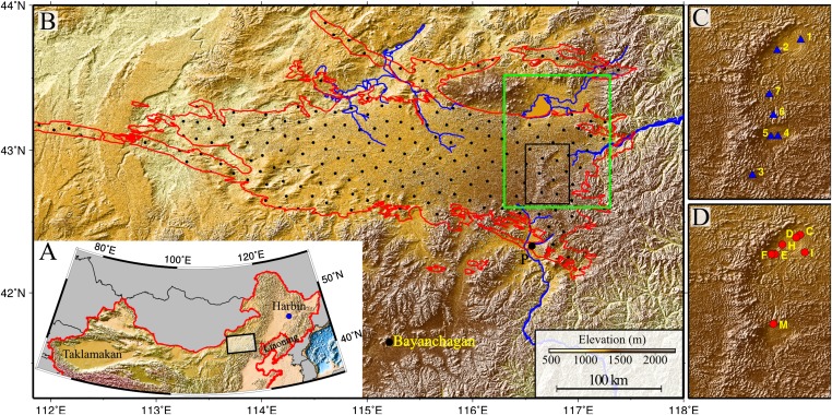
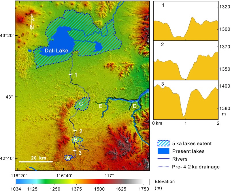
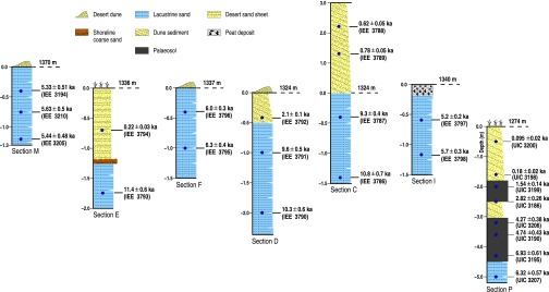
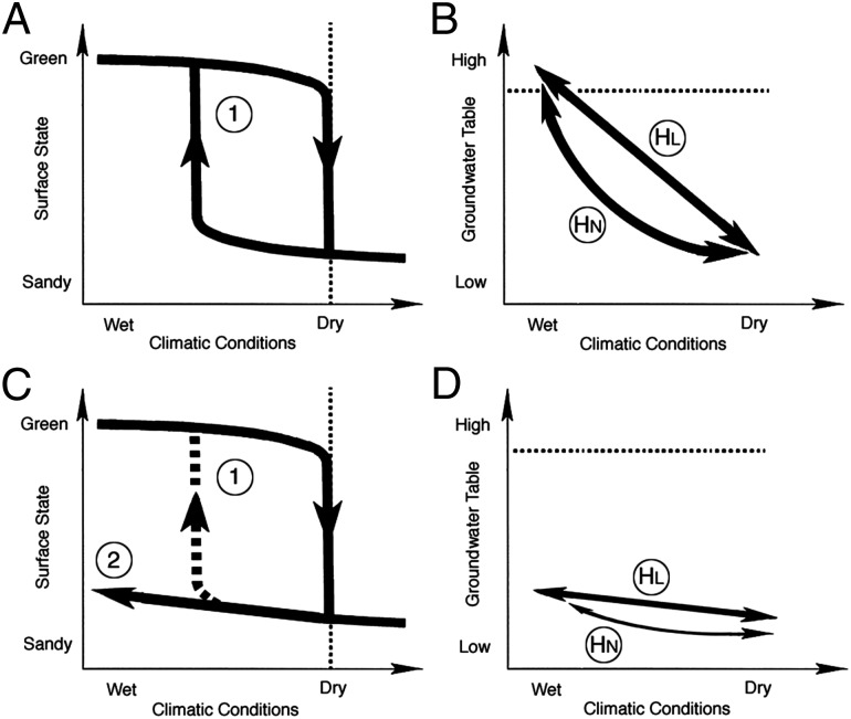
In the middle-to-late Holocene, Earth's monsoonal regions experienced catastrophic precipitation decreases that produced green to desert state shifts. Resulting hydrologic regime change negatively impacted water availability and Neolithic cultures. Whereas mid-Holocene drying is commonly attributed to slow insolation reduction and subsequent nonlinear vegetation-atmosphere feedbacks that produce threshold conditions, evidence of trigger events initiating state switching has remained elusive. Here we document a threshold event ca. 4,200 years ago in the Hunshandake Sandy Lands of Inner Mongolia, northern China, associated with groundwater capture by the Xilamulun River. This process initiated a sudden and irreversible region-wide hydrologic event that exacerbated the desertification of the Hunshandake, resulting in post-Humid Period mass migration of northern China's Neolithic cultures. The Hunshandake remains arid and is unlikely, even with massive rehabilitation efforts, to revert back to green conditions.

Keywords: Holocene; climate change; geology; geomorphology; human activity.


Conflict of interest statement

The authors declare no conflict of interest.

Figures

Fig. 1.
Fig. 1.
Geographical location of the Hunshandake Sandy Lands (A) and its area (encircled by red line in B). The black rectangle in B marks the location of the enlarged maps C and D on the Right, and the green rectangle shows the location of Fig. 2. Map C shows the localities of water samples, and map D shows the localities of sections with stratigraphy presented in Fig. 3. The sand–paleosol section P (Fig. 3) is on the southern margin, and the site Bayanchagan marks the coring site of ref. . Rivers with headwaters in the Hunshandake likely formed by groundwater sapping are marked in blue. Drainages to the southwest and west are currently undergoing groundwater sapping, with substantial spring-driven flow found at the current river base level.
Fig. 2.
Fig. 2.
(Left) Holocene lakes and channels in the Hunshandake and lake extent at selected epochs. Upper, middle, and lower lakes are indicated by points A, B, and C, respectively. Xilamulun River (point D) drains to the east. Groundwater-sapping headcuts at the upper reaches of incised canyons (point E) suggest a mid-Holocene interval of easterly surface flow, followed by groundwater drainage beginning at the ca. 4.2 ka event. Northern and central channels at point E are currently abandoned, and groundwater sapping has migrated to the southerly of the three channels shown. (Right) Cross-sections of the predrainage shift, northerly drainage into Dali Lake (Localities shown on the Left), showing the increase in widths of channels downstream (Vertical exaggeration ∼30:1).
Fig. 3.
Fig. 3.
Sedimentary profiles and their OSL chronologies along the former early-to-middle Holocene shoreline of the lower lake (E, F, D, C, and I) and middle lake (M) and section P in the southern margin of the Hunshandake (Fig. 1). IEE indicates the samples dated in the Institute of Earth Environment, Chinese Academy of Sciences, while UIC refers to the samples dated in the University of Illinois at Chicago.
Fig. 4.
Fig. 4.
Pathways by which the Sahara and Hunshandake responded to precipitation change induced by Holocene monsoonal penetration/strength variations. (A) As precipitation is reduced, the system moves toward a drier state, resulting in a state switch from green to desert. Subsequent wetter conditions result in a second state switch (pathway 1), with green conditions reestablished (the green switch occurs at precipitation levels indicated by the dotted vertical line in A and C). (B) Groundwater elevation change coincident with changing climate under a model where there are no constraints on groundwater levels. HL indicates a linear response, whereas HN is one of many possible nonlinear responses. (C) Alternative pathway 2, seen in the Hunshandake in response to a regional inability to maintain high groundwater levels due to drainage redirection and groundwater sapping because pathway 1 is no longer possible. Increased precipitation beyond currently documented Pleistocene/Holocene values (left of the y axis in the graph) results in removal of the sediments necessary to support a higher groundwater table. (D) Hydrologic responses, HL and HN, under all conditions no longer intersect the green state switch (dotted horizontal line in B and D) and are maintained at levels that cannot support a green Hunshandake.

Similar articles

Cited by

References

    1. Claussen M, et al. Simulation of an abrupt change in Saharan vegetation in the mid-Holocene. Geophys Res Lett. 1999;26(14):2037–2040.
    1. Foley JA, Coe MT, Scheffer M, Wang G. Regime shifts in the Sahara and Sahel: Interactions between ecological and climatic systems in northern Africa. Ecosystems (N Y) 2003;6(6):524–539.
    1. Scheffer M, Carpenter S, Foley JA, Folke C, Walker B. Catastrophic shifts in ecosystems. Nature. 2001;413(6856):591–596. - PubMed
    1. Higgins PAT, Mastrandrea MD, Schneider SH. Dynamics of climate and ecosystem coupling: Abrupt changes and multiple equilibria. Philos Trans R Soc Lond B Biol Sci. 2002;357(1421):647–655. - PMC - PubMed
    1. Scheffer M, Carpenter SR. Catastrophic regime shifts in ecosystems: Linking theory to observation. Trends Ecol Evol. 2003;18(12):648–656.

Publication types