

Efficient meltwater drainage through supraglacial streams and rivers on the southwest Greenland ice sheet
- PMID: 25583477
- PMCID: PMC4313838
- DOI: 10.1073/pnas.1413024112
Efficient meltwater drainage through supraglacial streams and rivers on the southwest Greenland ice sheet
Abstract
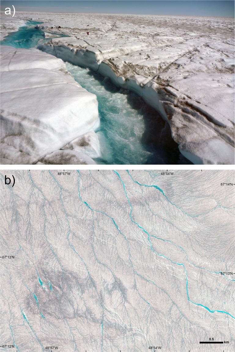
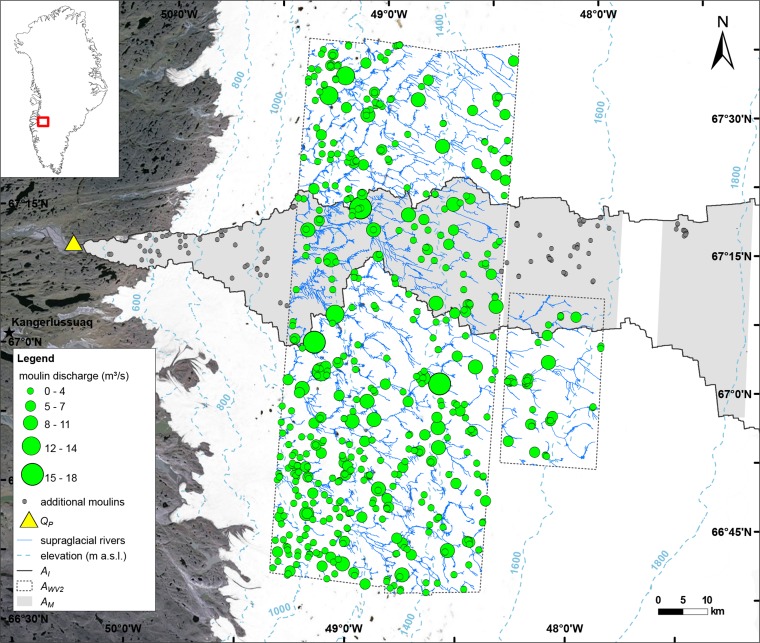
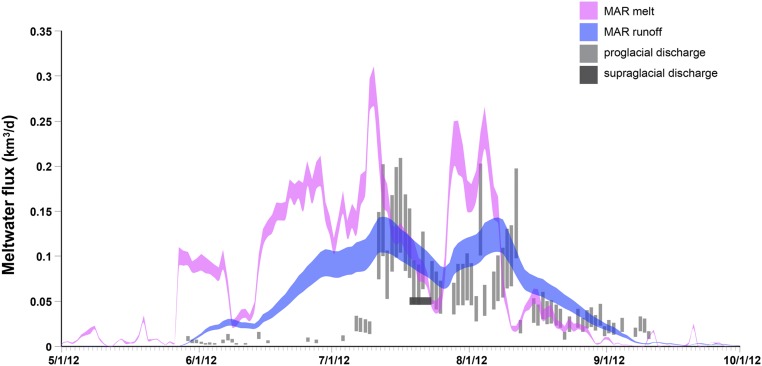
Thermally incised meltwater channels that flow each summer across melt-prone surfaces of the Greenland ice sheet have received little direct study. We use high-resolution WorldView-1/2 satellite mapping and in situ measurements to characterize supraglacial water storage, drainage pattern, and discharge across 6,812 km(2) of southwest Greenland in July 2012, after a record melt event. Efficient surface drainage was routed through 523 high-order stream/river channel networks, all of which terminated in moulins before reaching the ice edge. Low surface water storage (3.6 ± 0.9 cm), negligible impoundment by supraglacial lakes or topographic depressions, and high discharge to moulins (2.54-2.81 cm⋅d(-1)) indicate that the surface drainage system conveyed its own storage volume every <2 d to the bed. Moulin discharges mapped inside ∼52% of the source ice watershed for Isortoq, a major proglacial river, totaled ∼41-98% of observed proglacial discharge, highlighting the importance of supraglacial river drainage to true outflow from the ice edge. However, Isortoq discharges tended lower than runoff simulations from the Modèle Atmosphérique Régional (MAR) regional climate model (0.056-0.112 km(3)⋅d(-1) vs. ∼0.103 km(3)⋅d(-1)), and when integrated over the melt season, totaled just 37-75% of MAR, suggesting nontrivial subglacial water storage even in this melt-prone region of the ice sheet. We conclude that (i) the interior surface of the ice sheet can be efficiently drained under optimal conditions, (ii) that digital elevation models alone cannot fully describe supraglacial drainage and its connection to subglacial systems, and (iii) that predicting outflow from climate models alone, without recognition of subglacial processes, may overestimate true meltwater export from the ice sheet to the ocean.
Keywords: Greenland ice sheet; mass balance; meltwater runoff; remote sensing; supraglacial hydrology.
Conflict of interest statement
The authors declare no conflict of interest.
Figures
References
-
- van den Broeke M, et al. Partitioning recent Greenland mass loss. Science. 2009;326(5955):984–986. - PubMed
-
- Enderlin EM, et al. An improved mass budget for the Greenland ice sheet. Geophys Res Lett. 2014;41:866–872.
-
- Liang Y-L, et al. A decadal investigation of supraglacial lakes in West Greenland using a fully automatic detection and tracking algorithm. Remote Sens Environ. 2012;123:127–138.
-
- Colgan W, et al. An increase in crevasse extent, West Greenland: Hydrologic implications. Geophys Res Lett. 2011;38:1–7.
-
- McGrath D, Colgan W, Steffen K, Lauffenburger P, Balog J. Assessing the summer water budget of a moulin basin in the Sermeq Avannarleq ablation region, Greenland ice sheet. J Glaciol. 2011;57:954–964.
Publication types
LinkOut - more resources
Full Text Sources
Other Literature Sources
Molecular Biology Databases
Research Materials
