

Mapping migratory flyways in Asia using dynamic Brownian bridge movement models
- PMID: 25709838
- PMCID: PMC4337761
- DOI: 10.1186/s40462-015-0029-6
Mapping migratory flyways in Asia using dynamic Brownian bridge movement models
Abstract
Background: Identifying movement routes and stopover sites is necessary for developing effective management and conservation strategies for migratory animals. In the case of migratory birds, a collection of migration routes, known as a flyway, is often hundreds to thousands of kilometers long and can extend across political boundaries. Flyways encompass the entire geographic range between the breeding and non-breeding areas of a population, species, or a group of species, and they provide spatial frameworks for management and conservation across international borders. Existing flyway maps are largely qualitative accounts based on band returns and survey data rather than observed movement routes. In this study, we use satellite and GPS telemetry data and dynamic Brownian bridge movement models to build upon existing maps and describe waterfowl space use probabilistically in the Central Asian and East Asian-Australasian Flyways.
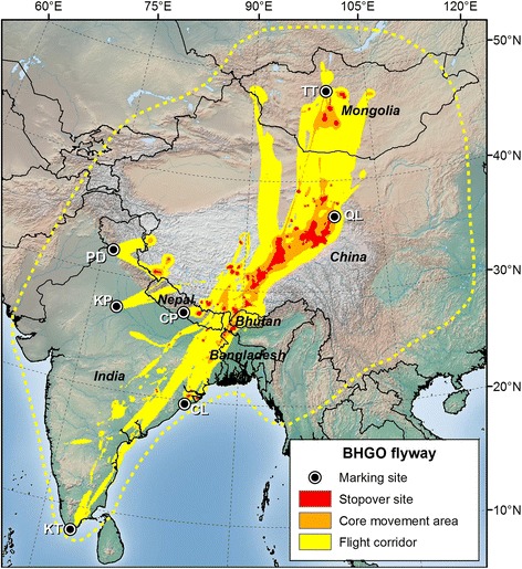
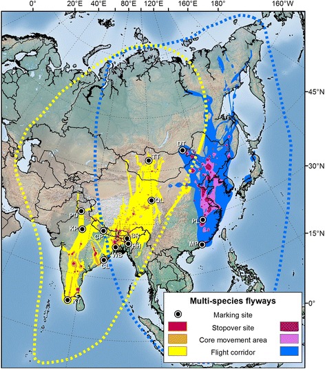
Results: Our approach provided new information on migratory routes that was not easily attainable with existing methods to describe flyways. Utilization distributions from dynamic Brownian bridge movement models identified key staging and stopover sites, migration corridors and general flyway outlines in the Central Asian and East Asian-Australasian Flyways. A map of space use from ruddy shelducks depicted two separate movement corridors within the Central Asian Flyway, likely representing two distinct populations that show relatively strong connectivity between breeding and wintering areas. Bar-headed geese marked at seven locations in the Central Asian Flyway showed heaviest use at several stopover sites in the same general region of high-elevation lakes along the eastern Qinghai-Tibetan Plateau. Our analysis of data from multiple Anatidae species marked at sites throughout Asia highlighted major movement corridors across species and confirmed that the Central Asian and East Asian-Australasian Flyways were spatially distinct.
Conclusions: The dynamic Brownian bridge movement model improves our understanding of flyways by estimating relative use of regions in the flyway while providing detailed, quantitative information on migration timing and population connectivity including uncertainty between locations. This model effectively quantifies the relative importance of different migration corridors and stopover sites and may help prioritize specific areas in flyways for conservation of waterbird populations.
Keywords: Dynamic Brownian bridge movement model; Flyways; Habitat conservation; Migration; Space use; Stopover sites; Waterfowl.
Figures

Similar articles
-
Optimal management of a multispecies shorebird flyway under sea-level rise.Conserv Biol. 2014 Dec;28(6):1710-20. doi: 10.1111/cobi.12319. Epub 2014 Jun 27. Conserv Biol. 2014. PMID: 24975747
-
New evidence for the east-west spread of the highly pathogenic avian influenza H5N1 virus between Central Asian and east Asian-Australasian flyways in China.Emerg Microbes Infect. 2019;8(1):823-826. doi: 10.1080/22221751.2019.1623719. Emerg Microbes Infect. 2019. PMID: 31164049 Free PMC article.
-
Mangcuo Lake in Hengduan Mountains: An Important Alpine Breeding and Stopover Site along Central Asian Flyway.Animals (Basel). 2023 Mar 23;13(7):1139. doi: 10.3390/ani13071139. Animals (Basel). 2023. PMID: 37048395 Free PMC article.
-
Deforestation within breeding ranges may still drive population trends of migratory forest birds in the East Asian Flyway.Sci Rep. 2023 Aug 27;13(1):14007. doi: 10.1038/s41598-023-40626-3. Sci Rep. 2023. PMID: 37635179 Free PMC article. Review.
-
Connectivity between countries established by landbirds and raptors migrating along the African-Eurasian flyway.Conserv Biol. 2023 Feb;37(1):e14002. doi: 10.1111/cobi.14002. Epub 2022 Dec 15. Conserv Biol. 2023. PMID: 36073347 Free PMC article. Review.
Cited by
-
African wild dog movements show contrasting responses to long and short term risk of encountering lions: analysis using dynamic Brownian bridge movement models.Mov Ecol. 2022 Mar 31;10(1):16. doi: 10.1186/s40462-022-00316-7. Mov Ecol. 2022. PMID: 35361272 Free PMC article.
-
Migration stopover ecology of Cinnamon Teal in western North America.Ecol Evol. 2021 Sep 21;11(20):14056-14069. doi: 10.1002/ece3.8115. eCollection 2021 Oct. Ecol Evol. 2021. PMID: 34707839 Free PMC article.
-
Interpolation of Point Prevalence Rate of the Highly Pathogenic Avian Influenza Subtype H5N8 Second Phase Epidemic in South Korea.Vet Sci. 2022 Mar 16;9(3):139. doi: 10.3390/vetsci9030139. Vet Sci. 2022. PMID: 35324867 Free PMC article.
-
Recent Population Dynamics of Japanese Encephalitis Virus.Viruses. 2023 Jun 2;15(6):1312. doi: 10.3390/v15061312. Viruses. 2023. PMID: 37376612 Free PMC article.
-
Deriving movement properties and the effect of the environment from the Brownian bridge movement model in monkeys and birds.Mov Ecol. 2015 Jun 15;3(1):18. doi: 10.1186/s40462-015-0043-8. eCollection 2015. Mov Ecol. 2015. PMID: 26078868 Free PMC article.
References
-
- Hutto RL. On the importance of en route periods to the conservation of migratory landbirds. Stud Avian Biol. 2000;20:109–14.
-
- Faaborg J, Holmes RT, Anders AD, Bildstein KL, Dugger KM, Gauthreaux SA, Heglund P, Hobson KA, Jahn AE, Johnson DH, Latta SC, Levey DJ, Marra PP, Merkord CL, Nol E, Rothstein SI, Sherry TW, Sillett TS, Thompson FR, III, Warnock N. Recent advances in understanding migration systems of New World land birds. Ecol Monogr. 2010;80:3–48. doi: 10.1890/09-0395.1. - DOI - PubMed
-
- Newton I. The Migration Ecology of Birds. San Francisco, CA: Academic Press; 2008.
-
- Sillett TS, Holmes RT. Variation in survivorship of a migratory songbird throughout its annual cycle. J Anim Ecol. 2002;71:296–308. doi: 10.1046/j.1365-2656.2002.00599.x. - DOI
LinkOut - more resources
Full Text Sources
Other Literature Sources
