. 2015 Mar 11;10(3):e0116200.
doi: 10.1371/journal.pone.0116200. eCollection 2015.

Assessment of habitat representation across a network of marine protected areas with implications for the spatial design of monitoring

Affiliations

Assessment of habitat representation across a network of marine protected areas with implications for the spatial design of monitoring

Mary Young et al. PLoS One. .

Abstract

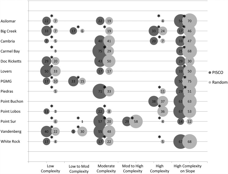
Networks of marine protected areas (MPAs) are being adopted globally to protect ecosystems and supplement fisheries management. The state of California recently implemented a coast-wide network of MPAs, a statewide seafloor mapping program, and ecological characterizations of species and ecosystems targeted for protection by the network. The main goals of this study were to use these data to evaluate how well seafloor features, as proxies for habitats, are represented and replicated across an MPA network and how well ecological surveys representatively sampled fish habitats inside MPAs and adjacent reference sites. Seafloor data were classified into broad substrate categories (rock and sediment) and finer scale geomorphic classifications standard to marine classification schemes using surface analyses (slope, ruggedness, etc.) done on the digital elevation model derived from multibeam bathymetry data. These classifications were then used to evaluate the representation and replication of seafloor structure within the MPAs and across the ecological surveys. Both the broad substrate categories and the finer scale geomorphic features were proportionately represented for many of the classes with deviations of 1-6% and 0-7%, respectively. Within MPAs, however, representation of seafloor features differed markedly from original estimates, with differences ranging up to 28%. Seafloor structure in the biological monitoring design had mismatches between sampling in the MPAs and their corresponding reference sites and some seafloor structure classes were missed entirely. The geomorphic variables derived from multibeam bathymetry data for these analyses are known determinants of the distribution and abundance of marine species and for coastal marine biodiversity. Thus, analyses like those performed in this study can be a valuable initial method of evaluating and predicting the conservation value of MPAs across a regional network.


Conflict of interest statement

Competing Interests: The authors have declared that no competing interests exist.

Figures

Fig 1
Fig 1. Central Coast MLPA Region.
Image on the left is the Central Coast MLPA region along the Central Coast of California and the MPAs within the region. SMCA are State Marine Conservation Areas with limited allowable take, SMR are State Marine Reserves with no recreational or commercial take. The Central Coast MLPA Region extends three nautical miles (boundary of state waters) from shore. The image on the right shows where this region falls along the California coast.
Fig 2
Fig 2. Example of results from the seafloor habitat classification within and around the Big Creek MPA.
The different shades of gray represent the different substrate types and depth zones.
Fig 3
Fig 3. Comparison of the MLPA-predicted habitat classifications using the best available data during the designation of the MPAs (left) and CSMP-derived habitats (right) in the Piedras Blancas MPA.
The MLPA-predicted habitats were derived from proxies for rock such as kelp forest coverage, rockfish fishing areas (the circular features in the image), or broad-scale predicted substrate maps. The CSMP-derived habitats were created based on the rugosity of the surface as a proxy for rock or sediment using the high-resolution digital elevation models from the CSMP data.
Fig 4
Fig 4. Shaded relief imagery of the seafloor produced from the digital elevation models (2m resolution, Sun Azimuth: 315, Sun Altitude: 45, Z-Factor: 3).
These images show the ecologically relevant variation in the structure of rocky reef along the central coast of California.
Fig 5
Fig 5. Comparison of the percentage of habitat classes derived from the CSMP data across the region (light gray) and within the MPAs (dark gray).
The asterisks (*) above the bars represent those pairs that fell outside the 20% threshold of similarity.
Fig 6
Fig 6. Comparison of the total percentage of each of the habitat classes derived from the cluster analysis within each of the 13 MPAs used in this analysis (light gray) and the percentage of PISCO transects that fell in those habitat classes (dark gray).
The size of the circles represent the percentage of transects in each of the corresponding habitat classes and are labeled with the percentage value. The black asterisks above the pairs of circles represent those habitat classes that were not well-represented in the monitoring transects within each of the MPAs. The black asterisks represent those habitat classes that were not well-represented by the monitoring transects based on the 20% deviance threshold.
Fig 7
Fig 7. Comparison of the habitat represented in the MPA monitoring transects (dark gray) and the habitat represented in the reference site transects (light gray) for each of the 13 MPAs looked at for this analysis.
The size of the circles represent the percentage of transects in each of the corresponding habitat classes and are labeled with that percentage. The black asterisks above the pairs of circles represent those habitat classes that were not proportionately sampled within each MPA and their corresponding reference sites *Note: transects represented in this figure are only those containing fish data. The invertebrate and algae transects were excluded from this analysis.

References

    1. Halpern BS, Walbridge S, Selkoe KA, Kappel CV, Micheli F, et al. (2008) A global map of human impact on marine ecosystems. Science 319: 948–952. 10.1126/science.1149345 - DOI - PubMed
    1. Halpern BS, Kappel CV, Selkoe KA, Micheli F, Ebert CM, et al. (2009) Mapping cumulative human impacts to California Current marine ecosystems. Conserv Lett 2(3): 138–148.
    1. Lester SE, McLeod KL, Tallis H, Ruckelshaus M, Halpern BS, et al. (2010) Science in support of ecosystem-based management for the US West Coast and beyond. Biol Conserv 143: 576–587.
    1. Brown JH (2011) Changes in ranges of large ocean fish. Proc Natl Acad Sci USA 108(29): 11735–11736. 10.1073/pnas.1109139108 - DOI - PMC - PubMed
    1. Douvere F (2008) The importance of marine spatial planning in advancing ecosystem-based sea use management. Mar Policy 32: 762–771.

Publication types