. 2015 Mar;5(6):1131-42.
doi: 10.1002/ece3.1418. Epub 2015 Feb 17.

Shifting ranges and conservation challenges for lemurs in the face of climate change

Affiliations

Shifting ranges and conservation challenges for lemurs in the face of climate change

Jason L Brown et al. Ecol Evol. 2015 Mar.

Abstract

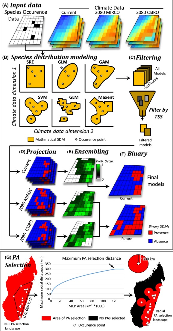
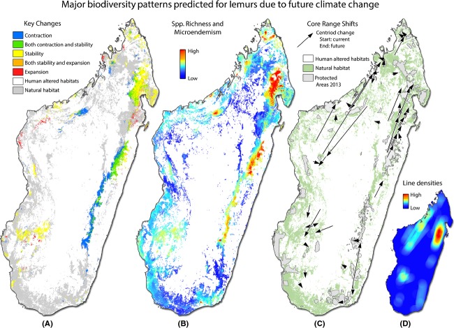
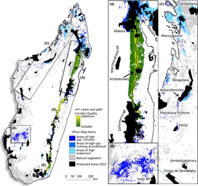
Geospatial modeling is one of the most powerful tools available to conservation biologists for estimating current species ranges of Earth's biodiversity. Now, with the advantage of predictive climate models, these methods can be deployed for understanding future impacts on threatened biota. Here, we employ predictive modeling under a conservative estimate of future climate change to examine impacts on the future abundance and geographic distributions of Malagasy lemurs. Using distribution data from the primary literature, we employed ensemble species distribution models and geospatial analyses to predict future changes in species distributions. Current species distribution models (SDMs) were created within the BIOMOD2 framework that capitalizes on ten widely used modeling techniques. Future and current SDMs were then subtracted from each other, and areas of contraction, expansion, and stability were calculated. Model overprediction is a common issue associated Malagasy taxa. Accordingly, we introduce novel methods for incorporating biological data on dispersal potential to better inform the selection of pseudo-absence points. This study predicts that 60% of the 57 species examined will experience a considerable range of reductions in the next seventy years entirely due to future climate change. Of these species, range sizes are predicted to decrease by an average of 59.6%. Nine lemur species (16%) are predicted to expand their ranges, and 13 species (22.8%) distribution sizes were predicted to be stable through time. Species ranges will experience severe shifts, typically contractions, and for the majority of lemur species, geographic distributions will be considerably altered. We identify three areas in dire need of protection, concluding that strategically managed forest corridors must be a key component of lemur and other biodiversity conservation strategies. This recommendation is all the more urgent given that the results presented here do not take into account patterns of ongoing habitat destruction relating to human activities.

Keywords: ANUSPLIN; BIOMOD; Madagascar; Strepsirrhini; ecological niche modeling; ensemble; least-cost corridors; micro-endemism; pseudo-absence selection; species distribution modeling.


Figures

Figure 1
Figure 1
Overview of species distribution modeling here employed. (A) Species occurrence data and climate data were prepared for Madagascar, (B) SDMs were built based on ten widely used modeling techniques (only six are pictured). (C) The resulting models, including replicates of each method, are filtered based on their abilities to predict known occurrences and pseudo-absences using a true skill statistic (TSS). (D) The resulting models with TTS values ≥ 0.85 were projected throughout the climate of the current landscape and two future climate models. (E) Models for each scenario are compiled and compared, creating an ensemble probabilistic density landscape depicting the probability of a species occurrence throughout the landscape. (F) The ensemble models were then converted to a binary “presence/absence” landscape from which all geospatial analyses were performed on. (G) To create high-quality species distribution models, we carefully selected pseudo-absences (PAs). Here, we select PAs within a variable distance from each known occurrence point determined by calculating the area of a minimum convex polygon from occurrence points and transforming that to reflect a logistic curve with values from 50 to 300 km. This method is sensitive to changes in smaller ranges, making it suitable for use on micro-endemic to broadly distributed species.
Figure 2
Figure 2
Major distribution patterns predicted for lemurs resulting from future climate change. (A) Depicts areas where three or more species will experience contraction, expansion, or stability. Cool colors correspond to areas of contraction and warmer colors depict areas of stability and expansion. (B) Depicts areas of high species richness and/or high levels of micro-endemism for both current and future (2080) scenarios. Warm colors depict areas with high biodiversity values at both time periods and should thus have the greatest conservation potential. (C) Map of core range shifts depicts the predicted distribution changes (based on the centers of their distributions) of each focal species. Each line depicts predicted distributional shifts of the species range centroid from current (start of arrow) to 2080 (end of arrow) scenarios. (D) Areas of highest conservation concern. The line densities depicted by warmer colors illustrate areas of high overlap in core range shifts through time. In these areas, it will be vital that protected areas are connected to facilitate dispersal into appropriate habitats.
Figure 3
Figure 3
Conservation priority areas. Three regions of Madagascar with highest priority for protection and conservation of lemurs and their cohabitants. (A) Area 1 of highest conservation concern. Core range shift analyses suggest that many of the east-central populations may need to disperse northward via the forests between Zahamena NP, Ambatovaky, and Makira. Using least-cost corridors and estimates of high current and future species richness and micro-endemism, we identify a series of corridors that connect these regions – traversing the habitat of the highest suitability and ecological stability for the highest number of species. (B) Second priority area surrounding the Mangoky River. This area is predicted to be central in facilitating dispersal among southwestern ecotones, but also a region predicted to act as a sanctuary for many lemur species. (C) Third priority region identified is a wide range habitat in the NW. This region has experienced widespread deforestation and a stepping-stone reserve network combined with selective reforestation might be feasible. Two specific areas with high levels of micro-endemism in this region are the coastal forests near Ambaliha and Antsirabe (situated west of Manongarivo) and the coastal forests around the village of Mariarano (west of Bongolava). See Fig. S2 for information regarding D and E.

References

    1. Anderson RP. Raza A. The effect of the extent of the study region on GIS models of species geographic distributions and estimates of niche evolution: preliminary tests with montane rodents (genus Nephelomys) in Venezuela. Journal of Biogeography. 2010;37:1378–1393. doi: . - DOI
    1. Anderson RP. A framework for using niche models to estimate impacts of climate change on species distributions. Ann. N. Y. Acad. Sci. 2013;1297:8–28. - PubMed
    1. Araujo MB. New M. Ensemble forecasting of species distributions. Trends Ecol. Evol. 2007;22:42–47. - PubMed
    1. Araujo MB. Rahbek C. How does climate change affect biodiversity? Science. 2006;313:1396–1397. - PubMed
    1. Barbet-Massin M, Jiguet F, Albert CH. Thuiller W. Selecting pseudo-absences for species distribution models: how, where and how many? Methods Ecol. Evol. 2012;3:327–338.

LinkOut - more resources