

Built environment and obesity by urbanicity in the U.S
- PMID: 25864019
- PMCID: PMC4497827
- DOI: 10.1016/j.healthplace.2015.03.010
Built environment and obesity by urbanicity in the U.S
Abstract
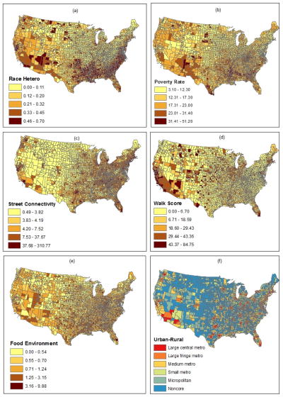
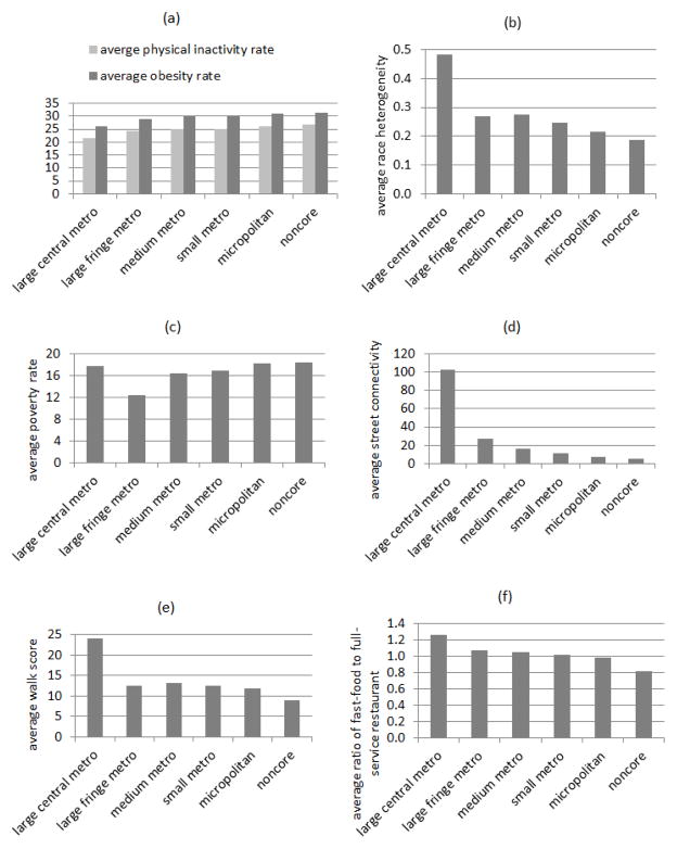
Based on the data from the Behavioral Risk Factor Surveillance System 2012, this study examines the association of neighborhood built environments with individual physical inactivity and obesity in the U.S. Multilevel modeling is used to control for the effects of individual socio-demographic characteristics. Neighborhood variables include built environment, poverty level and urbanicity at the county level. Among the built environment variables, a poorer street connectivity and a more prominent presence of fast-food restaurants are associated with a higher obesity risk (especially for areas of certain urbanicity levels). Analysis of data subsets divided by areas of different urbanicity levels and by gender reveals the variability of effects of independent variables, more so for the neighborhood variables than individual variables. This implies that some obesity risk factors are geographically specific and vary between men and women. The results lend support to the role of built environment in influencing people's health behavior and outcome, and promote public policies that need to be geographically adaptable and sensitive to the diversity of demographic groups.
Keywords: Built Environment; Food environment; Obesity; Urbanicity; Walk score.
Copyright © 2015 Elsevier Ltd. All rights reserved.
Figures
References
-
- Ahima RS, Lazar MA. The Health Risk of Obesity—Better Metrics Imperative. Science. 2013;341:856–858. - PubMed
-
- Ball K, Lamb K, Travaglini N, Ellaway A. Street connectivity and obesity in Glasgow, Scotland: Impact of age, sex and socioeconomic position. Health & Place. 2012;18:1307–1313. - PubMed
-
- Centers for Disease Control and Prevention (CDC) [last accessed 3-13-2015];Obesity Prevalence Maps 2013. 2015 available http://www.cdc.gov/obesity/data/table-adults.html.
-
- Chalkias C, Papadopoulos AG, Kalogeropoulos K, Tambalis K, Psarra G, Sidossis L. Geographical heterogeneity of the relationship between childhood obesity and socio-environmental status: Empirical evidence from Athens, Greece. Applied Geography. 2013;37:34–43.
Publication types
MeSH terms
Grants and funding
LinkOut - more resources
Full Text Sources
Other Literature Sources
Medical
