

Re-examining environmental correlates of Plasmodium falciparum malaria endemicity: a data-intensive variable selection approach
- PMID: 25890035
- PMCID: PMC4333887
- DOI: 10.1186/s12936-015-0574-x
Re-examining environmental correlates of Plasmodium falciparum malaria endemicity: a data-intensive variable selection approach
Abstract
Background: Malaria risk maps play an increasingly important role in disease control planning, implementation, and evaluation. The construction of these maps using modern geospatial techniques relies on covariate grids: continuous surfaces quantifying environmental factors that partially explain spatial heterogeneity in malaria endemicity. Although crucial, past variable selection processes for this purpose have often been subjective and ad-hoc, with many covariates used in modeling with little quantitative justification.
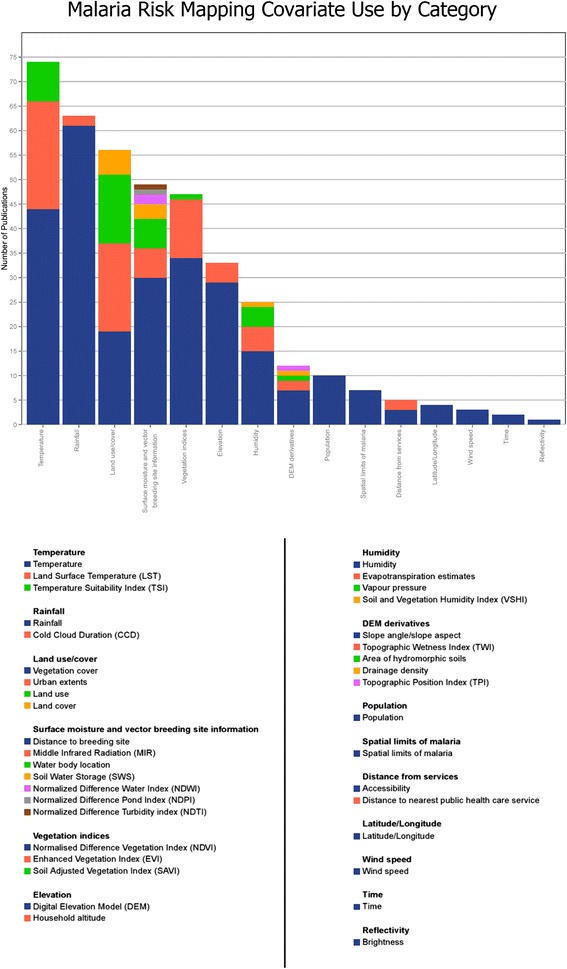
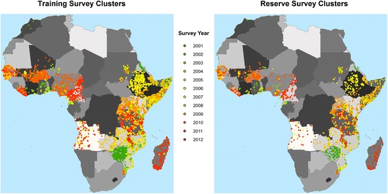
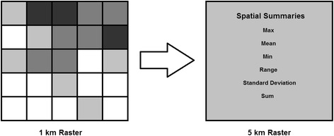
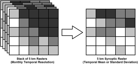
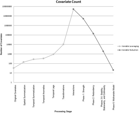
Methods: This research consists of an extensive covariate construction and selection process for predicting Plasmodium falciparum parasite rates (PfPR) in Africa for years 2000-2012. First, a literature review was conducted to establish a comprehensive list of covariates used for malaria mapping. Second, a library of covariate data was assembled to reflect this list, a process that included the construction of multiple, temporally dynamic datasets. Third, the resulting set of covariates was leveraged to create more than 50 million possible covariate terms via factorial combinations of different spatial and temporal aggregations, transformations, and pairwise interactions. Fourth, the expanded set of covariates was reduced via successive selection criteria to yield a robust covariate subset that was assessed using an out-of-sample validation approach.
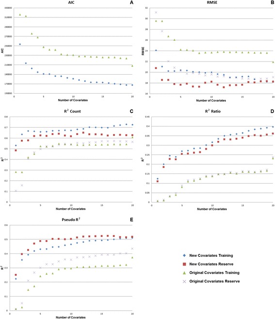
Results: The final covariate subset included predominately dynamic covariates and it substantially out-performed earlier sets used by the Malaria Atlas Project (MAP) for creating global malaria risk maps, with the pseudo-R(2) value for the out-of-sample validation increasing from 0.43 to 0.52. Dynamic covariates improved the model, with 17 of the 20 new covariates consisting of monthly or annual products, but the selected covariates were typically interaction terms that included both dynamic and synoptic datasets. Thus the interplay between normal (i.e., long-term averages) and immediate conditions may be key for characterizing environmental controls on parasite rate.
Conclusions: This analysis represents the first effort to systematically audit covariate utility for malaria mapping and then derive an objective, empirically based set of environmental covariates for modeling PfPR. The new covariates produce more reliable representations of malaria risk patterns and how they are changing through time, and these covariates will be used to characterize spatially and temporally varying environmental conditions affecting PfPR within a geostatistical-modeling framework, thus building upon previous research by MAP that produced global malaria maps for 2007 and 2010.
Figures
References
-
- Lysenko AJ, Semashko IN, editors. [Geography of malaria. A medico-geographic profile of an ancient disease](in Russian) Moscow: Academy of Sciences, USSR; 1968.
-
- Diggle PJ, Tawn JA, Moyeed RA. Model-based geostatistics. J R Stat Soc Ser C Appl Stat. 1998;47:299–326. doi: 10.1111/1467-9876.00113. - DOI
Publication types
MeSH terms
Grants and funding
LinkOut - more resources
Full Text Sources
Other Literature Sources
Miscellaneous
