. 2015 Jun 10:15:12.
doi: 10.1186/s12873-015-0036-3.

A remotely piloted aircraft system in major incident management: concept and pilot, feasibility study

Affiliations

A remotely piloted aircraft system in major incident management: concept and pilot, feasibility study

Håkon B Abrahamsen. BMC Emerg Med. .

Abstract

Background: Major incidents are complex, dynamic and bewildering task environments characterised by simultaneous, rapidly changing events, uncertainty and ill-structured problems. Efficient management, communication, decision-making and allocation of scarce medical resources at the chaotic scene of a major incident is challenging and often relies on sparse information and data. Communication and information sharing is primarily voice-to-voice through phone or radio on specified radio frequencies. Visual cues are abundant and difficult to communicate between teams and team members that are not co-located. The aim was to assess the concept and feasibility of using a remotely piloted aircraft (RPA) system to support remote sensing in simulated major incident exercises.

Methods: We carried out an experimental, pilot feasibility study. A custom-made, remotely controlled, multirotor unmanned aerial vehicle with vertical take-off and landing was equipped with digital colour- and thermal imaging cameras, a laser beam, a mechanical gripper arm and an avalanche transceiver. We collected data in five simulated exercises: 1) mass casualty traffic accident, 2) mountain rescue, 3) avalanche with buried victims, 4) fisherman through thin ice and 5) search for casualties in the dark.

Results: The unmanned aerial vehicle was remotely controlled, with high precision, in close proximity to air space obstacles at very low levels without compromising work on the ground. Payload capacity and tolerance to wind and turbulence were limited. Aerial video, shot from different altitudes, and remote aerial avalanche beacon search were streamed wirelessly in real time to a monitor at a ground base. Electromagnetic interference disturbed signal reception in the ground monitor.

Conclusion: A small remotely piloted aircraft can be used as an effective tool carrier, although limited by its payload capacity, wind speed and flight endurance. Remote sensing using already existing remotely piloted aircraft technology in pre-hospital environments is feasible and can be used to support situation assessment and information exchange at a major incident scene. Regulations are needed to ensure the safe use of unmanned aerial vehicles in major incidents. Ethical issues are abundant.


Figures
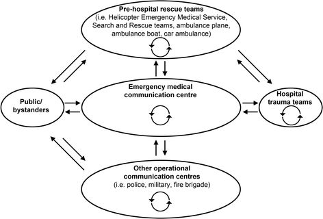
Fig. 1
Fig. 1
Typical communication links in major incident response in Norway. In the chain of pre-hospital emergency medical care, teams and team members are not usually co-located. In Norway, medical emergency calls from the public are handled by dispatchers at the local emergency medical communication centre who decide on the type of response needed [1]. The Joint Rescue Coordination Centres have overall operational responsibility during search and rescue operations. Together with the local emergency medical communication centres they coordinate and facilitate multidisciplinary cooperation and communication. Communication links, within and between teams, are depicted by curved and straight-lined bidirectional arrows, respectively. (Illustration: Kim Søderstrøm)
Fig. 2
Fig. 2
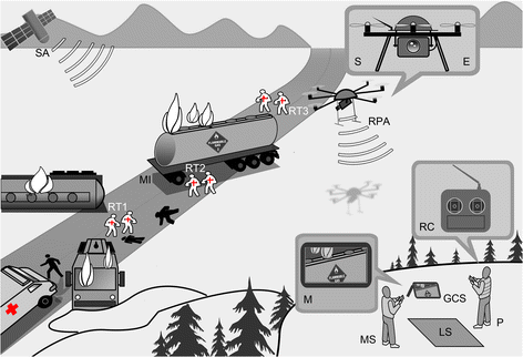
Concept of line-of-sight operation of a remotely piloted aircraft system in major incident management. A bus and a truck with flammable gas on fire after a collision. The unmanned remote piloted aircraft (RPA) is under the control of a remote pilot-in-command (P) on the ground assisted by a mission specialist (MS). Signals from satellites (SA) together with on-board automation such as a GPS module and a micro controller unit help to manoeuvre the vehicle. Real-time aerial video of the major incident (MI) scene is streamed to a ground control station (GSC) and displayed on the monitor (M). Pre-hospital rescue teams (RT1-3) that are not co-located treat injured trauma patients (black). (Illustration: Kim Søderstrøm)
Fig. 3
Fig. 3
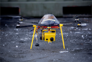
Remotely Piloted Aircraft (RPA). Radio controlled multirotor unmanned aerial vehicle with searchlight and video camera. (Photo: Adrian Johansen)
Fig. 4
Fig. 4
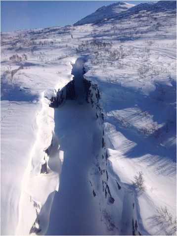
Airview of narrow canyon. A narrow canyon with steep rock faces and snowdrifts hanging over the edge was chosen as the location for a mountain rescue scenario. Note the big hole in the snow at the bottom of the canyon with running water beneath, not visible from the edge. Photo shot from inside a manned helicopter (EC 135). (Photo: Håkon B. Abrahamsen)
Fig. 5
Fig. 5
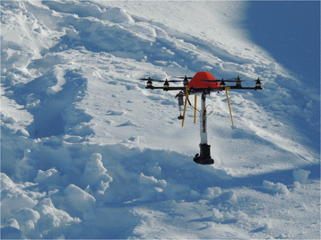
Avalanche beacon search from fixed altitude above the ground using a remotely piloted aircraft. A 50-cm hinged suspension system for a three-antenna 457-kHz avalanche transceiver (Mammut PULSE Barryvox) was used to avoid electromagnetic interference. (Photo: Håkon B. Abrahamsen)
Fig. 6
Fig. 6
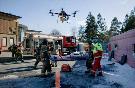
Remote sensing from a simulated major incident. Remotely piloted aircraft flying over a simulated major incident. A multiprofessional rescue team (front) working on the evacuation of a trauma patient from an overturned bus (right). The transmitting antenna that caused electromagnetic interference can be seen on top of the roof in the background. (Photo: Adrian Johansen)
Fig. 7
Fig. 7
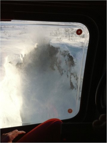
Low level flight over canyon. Low level flight over canyon with manned helicopter (EC 135). Downwash causes snow to swirl up, thereby restricting visibility. Photo shot from inside the helicopter. (Photo: Håkon B. Abrahamsen)

References

    1. Ellensen EN, Hunskaar S, Wisborg T, Zakariassen E. Variations in contact pattern and dispatch guideline adherence between Norwegian emergency medical communication centres - a cross-sectional study. Scand J Trauma Resusc Emerg Med. 2014;22:2. doi: 10.1186/1757-7241-22-2. - DOI - PMC - PubMed
    1. Reason J. Managing Organizational Accidents. Aldershot: Ashgate; 1997.
    1. Dalto JD, Weir C, Thomas F. Analyzing communication errors in an air medical transport service. Air Med J. 2013;32:129–37. doi: 10.1016/j.amj.2012.10.019. - DOI - PubMed
    1. Georgiou A, Lockey DJ. The performance and assessment of hospital trauma teams. Scand J Trauma Resusc Emerg Med. 2010;18:66. doi: 10.1186/1757-7241-18-66. - DOI - PMC - PubMed
    1. Flin R, O’Connor P, Crichton M. Safety at the Sharp End. A guide to non-technical skills. Aldershot: Ashgate; 2008.

Publication types