Unveiling Undercover Cropland Inside Forests Using Landscape Variables: A Supplement to Remote Sensing Image Classification
- PMID: 26098107
- PMCID: PMC4476797
- DOI: 10.1371/journal.pone.0130079
Unveiling Undercover Cropland Inside Forests Using Landscape Variables: A Supplement to Remote Sensing Image Classification
Erratum in
-
Correction: Unveiling Undercover Cropland Inside Forests Using Landscape Variables: A Supplement to Remote Sensing Image Classification.PLoS One. 2015 Aug 25;10(8):e0137150. doi: 10.1371/journal.pone.0137150. eCollection 2015. PLoS One. 2015. PMID: 26305460 Free PMC article. No abstract available.
Abstract
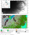
The worldwide demand for food has been increasing due to the rapidly growing global population, and agricultural lands have increased in extent to produce more food crops. The pattern of cropland varies among different regions depending on the traditional knowledge of farmers and availability of uncultivated land. Satellite images can be used to map cropland in open areas but have limitations for detecting undergrowth inside forests. Classification results are often biased and need to be supplemented with field observations. Undercover cropland inside forests in the Bale Mountains of Ethiopia was assessed using field observed percentage cover of land use/land cover classes, and topographic and location parameters. The most influential factors were identified using Boosted Regression Trees and used to map undercover cropland area. Elevation, slope, easterly aspect, distance to settlements, and distance to national park were found to be the most influential factors determining undercover cropland area. When there is very high demand for growing food crops, constrained under restricted rights for clearing forest, cultivation could take place within forests as an undercover. Further research on the impact of undercover cropland on ecosystem services and challenges in sustainable management is thus essential.
Conflict of interest statement
Figures


References
-
- Sankhayan PL, Hofstad O (2001) A village-level economic model of land clearing, grazing, and wood harvesting for sub-Saharan Africa: with a case study in southern Senegal. Ecol Econ 38: 423–440.
-
- Dereje GTD, Frank W, Hosein A, Mitiku H, Jan N (2013) International land deals, local people's livelihood, and environment nexus (How to create win-win land deals in Ethiopia?). In EGU General Assembly Conference Abstracts (Vol. 15, p. 3498).
Publication types
MeSH terms
LinkOut - more resources
Full Text Sources
Other Literature Sources

