. 2015 Jul 28:5:12505.
doi: 10.1038/srep12505.

Seagrass meadows (Posidonia oceanica) distribution and trajectories of change

Affiliations

Seagrass meadows (Posidonia oceanica) distribution and trajectories of change

Luca Telesca et al. Sci Rep. .

Abstract

Posidonia oceanica meadows are declining at alarming rates due to climate change and human activities. Although P. oceanica is considered the most important and well-studied seagrass species of the Mediterranean Sea, to date there has been a limited effort to combine all the spatial information available and provide a complete distribution of meadows across the basin. The aim of this work is to provide a fine-scale assessment of (i) the current and historical known distribution of P. oceanica, (ii) the total area of meadows and (iii) the magnitude of regressive phenomena in the last decades. The outcomes showed the current spatial distribution of P. oceanica, covering a known area of 1,224,707 ha, and highlighted the lack of relevant data in part of the basin (21,471 linear km of coastline). The estimated regression of meadows amounted to 34% in the last 50 years, showing that this generalised phenomenon had to be mainly ascribed to cumulative effects of multiple local stressors. Our results highlighted the importance of enforcing surveys to assess the status and prioritize areas where cost-effective schemes for threats reduction, capable of reversing present patterns of change and ensuring P. oceanica persistence at Mediterranean scale, could be implemented.


Figures

Figure 1
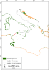
Figure 1. Current distribution of Posidonia oceanica meadows.
The current distribution of P. oceanica (green areas) along the Mediterranean Sea coastline, based on collated spatial information available on meadow presence. Map created with ArcGIS® software by Esri (Environmental Systems Resource Institute, ArcMap 9.3, www.esri.com) using data from OpenStreetMap.org (© OpenStreetMap contributors59).
Figure 2
Figure 2. Detail of the current distribution of Posidonia oceanica meadows in the Western Mediterranean Sea.
Map created with ArcGIS® software by Esri (Environmental Systems Resource Institute, ArcMap 9.3, www.esri.com) using data from OpenStreetMap.org (© OpenStreetMap contributors59).
Figure 3
Figure 3. Detail of the current distribution of Posidonia oceanica meadows in the Central Mediterranean Sea.
The red line marks the border between the Western and the Eastern Mediterranean Basin. Map created with ArcGIS® software by Esri (Environmental Systems Resource Institute, ArcMap 9.3, www.esri.com) using data from OpenStreetMap.org (© OpenStreetMap contributors59).
Figure 4
Figure 4. Detail of the current distribution of Posidonia oceanica meadows in the Eastern Mediterranean Sea.
Map created with ArcGIS® software by Esri (Environmental Systems Resource Institute, ArcMap 9.3, www.esri.com) using data from OpenStreetMap.org (© OpenStreetMap contributors59).
Figure 5
Figure 5. Coastline with regression of Posidonia oceanica meadows.
Know areas with reported P. oceanica meadows loss (red areas) across the Mediterranean Sea over the last 50 years. Map created with ArcGIS® software by Esri (Environmental Systems Resource Institute, ArcMap 9.3, www.esri.com) using data from OpenStreetMap.org (© OpenStreetMap contributors59).
Figure 6
Figure 6. An example of the GIS output.
Posidonia oceanica meadows in the Gulf of Asinara (Sardinia, Italy). The green areas represent the current distribution of P. oceanica, the red areas represent dead matte, which was used to estimate the regression. Map created with ArcGIS® software by Esri (Environmental Systems Resource Institute, ArcMap 9.3, www.esri.com) using data from OpenStreetMap.org (© OpenStreetMap contributors59).

References

    1. Hemminga M. A. & Duarte C. M. in Seagrass Ecology 298 pp (Cambridge University Press, 2000).
    1. Nellemann C. et al. in Blue Carbon: The Role of Healthy Oceans in Binding Carbon. A Rapid Response Assessment 80 pp. (GRID-Arendal, 2009).
    1. Orth R. J. et al. A global crisis for seagrass ecosystems. Bioscience 56, 987–996 (2006).
    1. Marbà N., Diaz-Almela E. & Duarte C. M. Mediterranean seagrass (Posidonia oceanica) loss between 1842 and 2009. Biol. Conserv. 176, 183–190 (2014).
    1. Waycott M. et al. Accelerating loss of seagrasses across the globe threatens coastal ecosystems. P. Natl. Acad. Sci. USA 106, 12377–12381 (2009). - PMC - PubMed

Publication types

LinkOut - more resources