. 2015 Jul 31;10(7):e0133381.
doi: 10.1371/journal.pone.0133381. eCollection 2015.

Income Disparities and the Global Distribution of Intensively Farmed Chicken and Pigs

Affiliations

Income Disparities and the Global Distribution of Intensively Farmed Chicken and Pigs

Marius Gilbert et al. PLoS One. .

Abstract

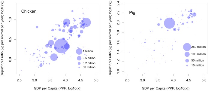
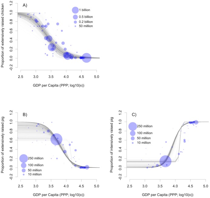
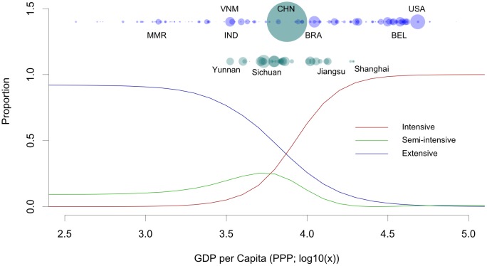
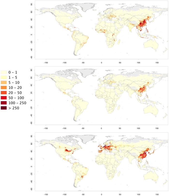
The rapid transformation of the livestock sector in recent decades brought concerns on its impact on greenhouse gas emissions, disruptions to nitrogen and phosphorous cycles and on land use change, particularly deforestation for production of feed crops. Animal and human health are increasingly interlinked through emerging infectious diseases, zoonoses, and antimicrobial resistance. In many developing countries, the rapidity of change has also had social impacts with increased risk of marginalisation of smallholder farmers. However, both the impacts and benefits of livestock farming often differ between extensive (backyard farming mostly for home-consumption) and intensive, commercial production systems (larger herd or flock size, higher investments in inputs, a tendency towards market-orientation). A density of 10,000 chickens per km2 has different environmental, epidemiological and societal implications if these birds are raised by 1,000 individual households or in a single industrial unit. Here, we introduce a novel relationship that links the national proportion of extensively raised animals to the gross domestic product (GDP) per capita (in purchasing power parity). This relationship is modelled and used together with the global distribution of rural population to disaggregate existing 10 km resolution global maps of chicken and pig distributions into extensive and intensive systems. Our results highlight countries and regions where extensive and intensive chicken and pig production systems are most important. We discuss the sources of uncertainties, the modelling assumptions and ways in which this approach could be developed to forecast future trajectories of intensification.


Conflict of interest statement

Competing Interests: The authors have declared that no competing interests exist.

Figures

Fig 1
Fig 1. Productivity (kg of meat per animal per year) as a function of Gross Domestic Product per capita (USD in purchasing power parity in 2010).
Each dot represents a country, with the size indicative of the stock according to FAOSTAT [5]. Only countries with stocks > 0 for chickens (n = 190) and pigs (n = 170) are included.
Fig 2
Fig 2. Models of the proportions of extensively raised chickens (a) and pigs (b) and of intensively-raised pigs (c) as a function of GDP per capita (USD, Purchasing Power Parity for 2010).
Each dot represents a country for which P ext and P int was established through data-mining (n = 86 for chicken, n = 97 for pig), with the size indicative of the stock according to FAOSTAT [5].
Fig 3
Fig 3. Predicted proportions of pigs raised under extensive, semi-intensive and intensive production systems as a function of GDP per capita (USD, Purchasing Power Parity).
The top row of points indicates the position of different countries along the gradient of GDP per capita, with the size of the points indicative of the national stock according to FAOSTAT [5]. A selection of countries is indicated by their ISO-3 codes.
Fig 4
Fig 4. Distribution of chickens (birds per square kilometre) raised under extensive (a) and intensive (b) production systems (unprojected lat/long decimal degrees coordinate system, WGS 84).
The data used to produce these maps were all from public sources (detailed in the Material and Method section), and the country limit data are from the FAO Global Administrative Unit Layers (GAUL) database.
Fig 5
Fig 5. Distribution of pigs (head per square kilometre) raised under extensive (a), semi-intensive (b) and intensive (c) production systems (unprojected lat/long decimal degrees coordinate system, WGS 84).
The data used to produce these maps were all from public sources (detailed in the Material and Method section), and the country limit data are from the FAO Global Administrative Unit Layers (GAUL) database.
Fig 6
Fig 6. Extensively and intensively raised chickens in Thailand according to the current methodology (a and b, respectively) and that of Van Boeckel et al. [8] (c and d, respectively) (unprojected lat/long decimal degrees coordinate system, WGS 84).
The data used to produce these maps were all from public sources (detailed in the Material and Method section) and the country limit data are from the FAO Global Administrative Unit Layers (GAUL) database.

References

    1. Smil V. Worldwide transformation of diets, burdens of meat production and opportunities for novel food proteins. Enzyme and Microbial Technology. 2002;30: 305–311.
    1. Fowler CW, Hobbs L. Is humanity sustainable? Proc Biol Sci. 2003;270: 2579–2583. 10.1098/rspb.2003.2553 - DOI - PMC - PubMed
    1. Delgado CL. Livestock to 2020: The next food revolution. Intl Food Policy Res Inst; 1999.
    1. Steinfeld H. The livestock revolution—a global veterinary mission. Veterinary parasitology. 2004;125: 19–41. - PubMed
    1. FAO. FAO Statistical Database. Available on http://faostat.fao.org/; 2009.

Publication types