Rapid sequestration of rock avalanche deposits within glaciers
- PMID: 26286361
- PMCID: PMC4560769
- DOI: 10.1038/ncomms8964
Rapid sequestration of rock avalanche deposits within glaciers
Abstract
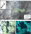
Topographic development in mountainous landscapes is a complex interplay between tectonics, climate and denudation. Glaciers erode valleys to generate headwall relief, and hillslope processes control the height and retreat of the peaks. The magnitude-frequency of these landslides and their long-term ability to lower mountains above glaciers is poorly understood; however, small, frequent rockfalls are currently thought to dominate. The preservation of rarer, larger, landslide deposits is exceptionally short-lived, as they are rapidly reworked. The 2013 Mount Haast rock avalanche that failed from the slopes of Aoraki/Mount Cook, New Zealand, onto the glacier accumulation zone below was invisible to conventional remote sensing after just 3 months. Here we use sub-surface data to reveal the now-buried landslide deposit, and suggest that large landslides are the primary hillslope erosion mechanism here. These data show how past large landslides can be identified in accumulation zones, providing an untapped archive of erosive events in mountainous landscapes.
Figures


References
-
- Herman F. et al. Worldwide acceleration of mountain erosion under a cooling climate. Nature 504, 423–426 (2013). - PubMed
-
- Thomson S. N. et al. Glaciation as a destructive and constructive control on mountain building. Nature 467, 313–317 (2010). - PubMed
-
- Korup O. et al. Giant landslides, topography, and erosion. Earth Planet. Sci. Lett. 261, 578–589 (2007).
-
- Hovius N., Stark C. P. & Allen P. A. Sediment flux from a mountain belt derived by landslide mapping. Geology 25, 231–234 (1997).
-
- Deline P., Hewitt K., Reznichenko N. & Shugar D. in Landslide Hazards, Risks, and Disasters ed. Davies T. 263–320Elsevier (2014).
Publication types
LinkOut - more resources
Full Text Sources
Other Literature Sources
Miscellaneous

