

Multilevel models for evaluating the risk of pedestrian-motor vehicle collisions at intersections and mid-blocks
- PMID: 26339944
- PMCID: PMC4598311
- DOI: 10.1016/j.aap.2015.08.013
Multilevel models for evaluating the risk of pedestrian-motor vehicle collisions at intersections and mid-blocks
Abstract
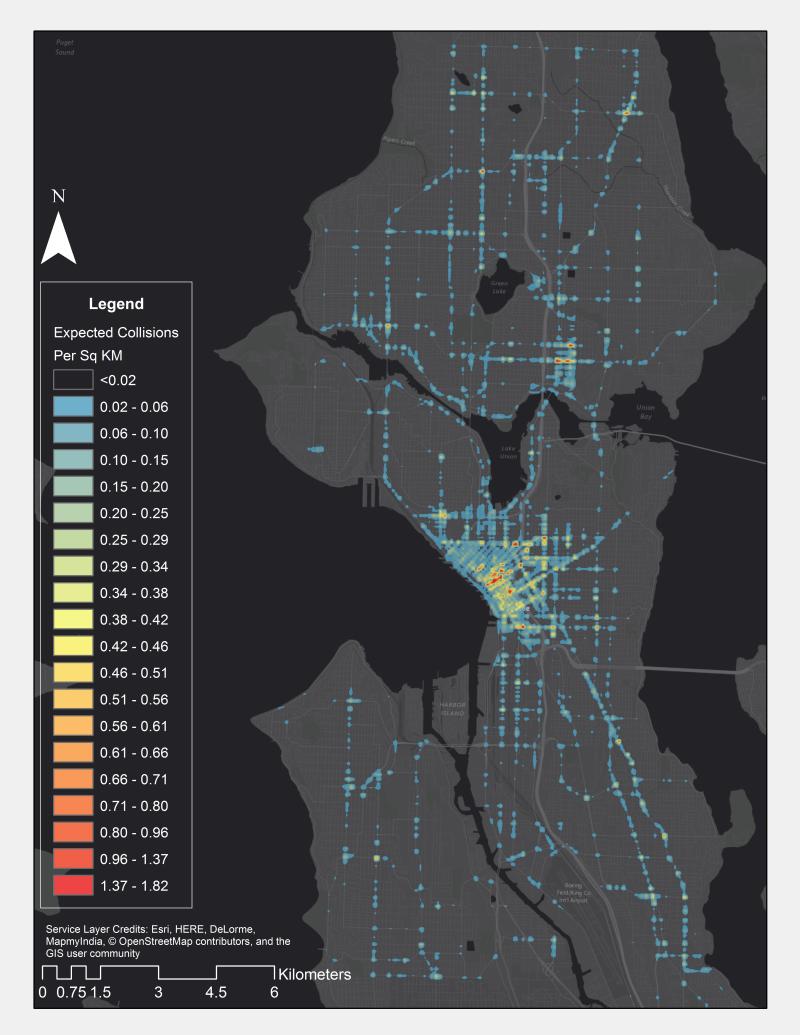
Walking is a popular form of physical activity associated with clear health benefits. Promoting safe walking for pedestrians requires evaluating the risk of pedestrian-motor vehicle collisions at specific roadway locations in order to identify where road improvements and other interventions may be needed. The objective of this analysis was to estimate the risk of pedestrian collisions at intersections and mid-blocks in Seattle, WA. The study used 2007-2013 pedestrian-motor vehicle collision data from police reports and detailed characteristics of the microenvironment and macroenvironment at intersection and mid-block locations. The primary outcome was the number of pedestrian-motor vehicle collisions over time at each location (incident rate ratio [IRR] and 95% confidence interval [95% CI]). Multilevel mixed effects Poisson models accounted for correlation within and between locations and census blocks over time. Analysis accounted for pedestrian and vehicle activity (e.g., residential density and road classification). In the final multivariable model, intersections with 4 segments or 5 or more segments had higher pedestrian collision rates compared to mid-blocks. Non-residential roads had significantly higher rates than residential roads, with principal arterials having the highest collision rate. The pedestrian collision rate was higher by 9% per 10 feet of street width. Locations with traffic signals had twice the collision rate of locations without a signal and those with marked crosswalks also had a higher rate. Locations with a marked crosswalk also had higher risk of collision. Locations with a one-way road or those with signs encouraging motorists to cede the right-of-way to pedestrians had fewer pedestrian collisions. Collision rates were higher in locations that encourage greater pedestrian activity (more bus use, more fast food restaurants, higher employment, residential, and population densities). Locations with higher intersection density had a lower rate of collisions as did those in areas with higher residential property values. The novel spatiotemporal approach used that integrates road/crossing characteristics with surrounding neighborhood characteristics should help city agencies better identify high-risk locations for further study and analysis. Improving roads and making them safer for pedestrians achieves the public health goals of reducing pedestrian collisions and promoting physical activity.
Keywords: Built environment; Collision risk; Multilevel model; Pedestrians.
Copyright © 2015 Elsevier Ltd. All rights reserved.
Figures
Similar articles
-
Pedestrian signalization and the risk of pedestrian-motor vehicle collisions in Lima, Peru.Accid Anal Prev. 2014 Sep;70:273-81. doi: 10.1016/j.aap.2014.04.012. Epub 2014 May 10. Accid Anal Prev. 2014. PMID: 24821630 Free PMC article.
-
The risk of pedestrian injury and fatality in collisions with motor vehicles, a social ecological study of state routes and city streets in King County, Washington.Accid Anal Prev. 2011 Jan;43(1):11-24. doi: 10.1016/j.aap.2009.12.008. Epub 2010 Sep 16. Accid Anal Prev. 2011. PMID: 21094292
-
Exploring the impact of a dedicated streetcar right-of-way on pedestrian motor vehicle collisions: a quasi experimental design.Accid Anal Prev. 2014 Oct;71:222-7. doi: 10.1016/j.aap.2014.05.022. Epub 2014 Jun 18. Accid Anal Prev. 2014. PMID: 24950129
-
A comparison of factors influencing the safety of pedestrians accessing bus stops in countries of differing income levels.Accid Anal Prev. 2024 Nov;207:107725. doi: 10.1016/j.aap.2024.107725. Epub 2024 Aug 2. Accid Anal Prev. 2024. PMID: 39096538 Review.
-
Environmental measures to improve pedestrian safety in low- and middle-income countries: a scoping review.Glob Health Promot. 2024 Dec;31(4):44-55. doi: 10.1177/17579759241241513. Epub 2024 May 8. Glob Health Promot. 2024. PMID: 38716695 Free PMC article.
Cited by
-
Intersections and Non-Intersections: A Protocol for Identifying Pedestrian Crash Risk Locations in GIS.Int J Environ Res Public Health. 2019 Sep 24;16(19):3565. doi: 10.3390/ijerph16193565. Int J Environ Res Public Health. 2019. PMID: 31554231 Free PMC article.
-
Qualitative Field Observation of Pedestrian Injury Hotspots: A Mixed-Methods Approach for Developing Built- and Socioeconomic-Environmental Risk Signatures.Int J Environ Res Public Health. 2020 Mar 20;17(6):2066. doi: 10.3390/ijerph17062066. Int J Environ Res Public Health. 2020. PMID: 32244976 Free PMC article.
-
Examining Injury Severity of Pedestrians in Vehicle-Pedestrian Crashes at Mid-Blocks Using Path Analysis.Int J Environ Res Public Health. 2020 Aug 25;17(17):6170. doi: 10.3390/ijerph17176170. Int J Environ Res Public Health. 2020. PMID: 32854407 Free PMC article.
-
"My right to walk, my right to live": pedestrian fatalities, roads and environmental features in Benin.BMC Public Health. 2021 Jan 19;21(1):162. doi: 10.1186/s12889-021-10192-2. BMC Public Health. 2021. PMID: 33468090 Free PMC article.
-
Patterns of Brain Injury and Clinical Outcomes Related to Trauma from Collisions Involving Motor Vehicles.J Clin Med. 2024 Dec 10;13(24):7500. doi: 10.3390/jcm13247500. J Clin Med. 2024. PMID: 39768423 Free PMC article.
References
-
- Adams M, Frank L, Schipperijn J, Smith G, Chapman J, Christiansen L, Coffee N, Salvo D, Du Toit L, Dygryn J, Hino AA, Lai P-C, Mavoa S, Pinzon J, Van De Weghe N, Cerin E, Davey R, Macfarlane D, Owen N, Sallis J. International variation in neighborhood walkability, transit, and recreation environments using geographic information systems: The ipen adult study. International Journal of Health Geographics. 2014;13(1):43. - PMC - PubMed
-
- Aguero-Valverde J, Jovanis P. Spatial correlation in multilevel crash frequency models. Transportation Research Record: Journal of the Transportation Research Board. 2010;2165(-1):21–32.
-
- Ameratunga S, Hijar M, Norton R. Road-traffic injuries: Confronting disparities to address a global-health problem. The Lancet. 2006;367(9521):1533–1540. - PubMed
-
- Badland H, Schofield G. Transport, urban design, and physical activity: An evidence-based update. Transportation Research Part D-Transport and Environment. 2005;10(3):177–196.
-
- Brüde U, Larsson J. Models for predicting accidents at junctions where pedestrians and cyclists are involved. How well do they fit? Accident Analysis & Prevention. 1993;25(5):499–509. - PubMed
Publication types
MeSH terms
Grants and funding
LinkOut - more resources
Full Text Sources
Other Literature Sources
Medical
