. 2015 Sep 15;3(1):23.
doi: 10.1186/s40462-015-0055-4. eCollection 2015.

Step by step: reconstruction of terrestrial animal movement paths by dead-reckoning

Affiliations

Step by step: reconstruction of terrestrial animal movement paths by dead-reckoning

O R Bidder et al. Mov Ecol. .

Abstract

Background: Research on wild animal ecology is increasingly employing GPS telemetry in order to determine animal movement. However, GPS systems record position intermittently, providing no information on latent position or track tortuosity. High frequency GPS have high power requirements, which necessitates large batteries (often effectively precluding their use on small animals) or reduced deployment duration. Dead-reckoning is an alternative approach which has the potential to 'fill in the gaps' between less resolute forms of telemetry without incurring the power costs. However, although this method has been used in aquatic environments, no explicit demonstration of terrestrial dead-reckoning has been presented.

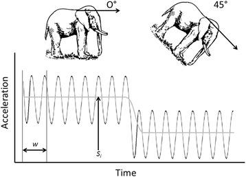
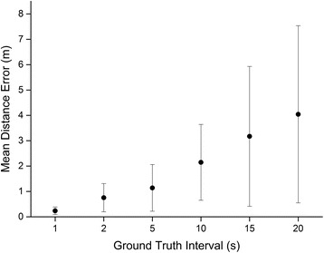
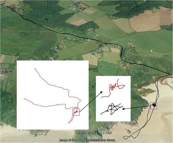
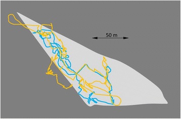
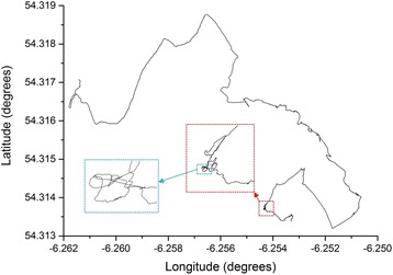
Results: We perform a simple validation experiment to assess the rate of error accumulation in terrestrial dead-reckoning. In addition, examples of successful implementation of dead-reckoning are given using data from the domestic dog Canus lupus, horse Equus ferus, cow Bos taurus and wild badger Meles meles.

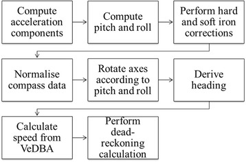
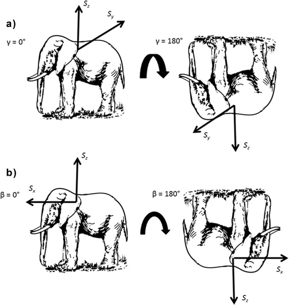
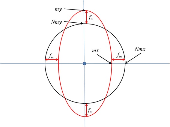
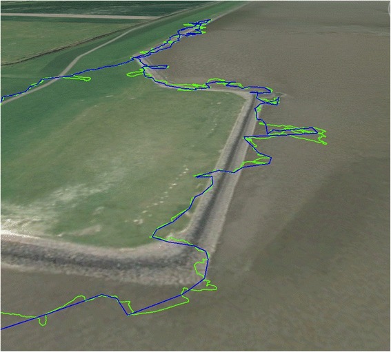
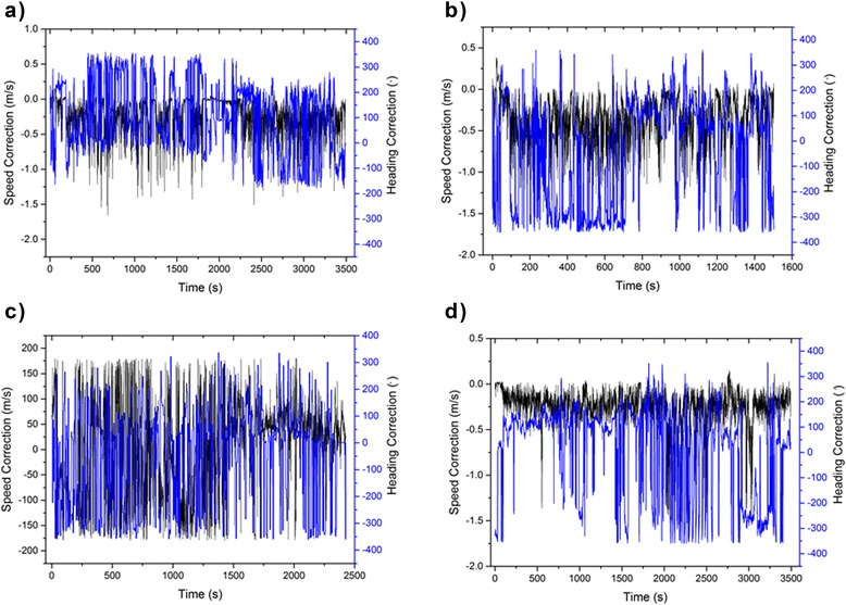
Conclusions: This study documents how terrestrial dead-reckoning can be undertaken, describing derivation of heading from tri-axial accelerometer and tri-axial magnetometer data, correction for hard and soft iron distortions on the magnetometer output, and presenting a novel correction procedure to marry dead-reckoned paths to ground-truthed positions. This study is the first explicit demonstration of terrestrial dead-reckoning, which provides a workable method of deriving the paths of animals on a step-by-step scale. The wider implications of this method for the understanding of animal movement ecology are discussed.

Keywords: GPS; Step length; animal movement; dead reckoning; terrestrial.


Figures

Fig. 1
Fig. 1
Flow diagram showing the process required to perform dead-reckoning
Fig. 2
Fig. 2
Idealised illustration of how static acceleration (Si) is calculated using a moving average of window size w. The locomotion of the animal produces a charicteristic waveform, which oscillates around the static acceleration Si
Fig. 3
Fig. 3
Illustration of how changes in body orientation, i.e. a Roll (γ), b Pitch (β), produce changes in static acceleration. Sx represents the Heave axis (dorso-ventral), Sy represents the Surge axis (anterior-posterior), and Sz represents the Sway axis (lateral)
Fig. 4
Fig. 4
Visualisation of magnetometer data where distortions in the magnetic field due to soft iron sources near to the sensors may change the expected outputs on the various axes (two of three shown for simplicity). This can be corrected by appropriate normalising procedure (see text)
Fig. 5
Fig. 5
Visualisation of displacement correction for the magnetometer output in two axes. The red circle represents data for a 360° rotation from two magnetometer axes that are subject to displacement from the true point of origin (black circle) by hard iron distortion
Fig. 6
Fig. 6
Illustration of how the distance correction factor is calculated. The correction factor is then applied to all distance calculations so that dead-reckoned and ground-truthed positions accord
Fig. 7
Fig. 7
When distances between two time-synchronized positions derived from both GPS and dead-reckoned are equal but there is displacement between dead-reckoned and GPS-derived positions, a heading error is likely to have occurred but can be corrected (see text)
Fig. 8
Fig. 8
2D paths of the human participant as determined by a Video Recording, b GPS, c Dead-Reckoning without correction, d Dead-Reckoning with correction every 2 s, e Dead-Reckoning with correction every 5 s, f Dead-Reckoning with correction every 10 s
Fig. 9
Fig. 9
Mean Distance Error (m) at each of the ground-truthing regimes. Error bars represent Standard Deviation of the Mean
Fig. 10
Fig. 10
The movements of a rider-directed horse Equus ferus caballus, starting and ending in the top left corner, as elucidated by GPS (at 1 Hz - black track) and dead-reckoning (at 20 Hz) without any ground-truthed points (red track). Note that the dead-reckoned trace has no scale since the distance moved is derived from the speed and this is assumed to be linearly related to VeDBA, with a nominal relationship until ground-truthed (see text). The two dashed squares show a period when the horse was directed to move in tight circles. For scale, the total track length according to the GPS (black track) was 10.127 km
Fig. 11
Fig. 11
Movement path of a domestic dog. The purple track displays the GPS data (at 0.2 Hz) while the green shows the dead-reckoned path (at 40 Hz). For scale, the total track length according to the GPS was 3.040 km. Note the additional track tortuosity of the dead-reckoned track
Fig. 12
Fig. 12
Changes in speed and heading correction factors necessary to tie dead-reckoned tracks into those acquired by GPS during deployment of a GPS-enabled DD on a) dog 1, b) dog 2, c) dog 3 and d) a horse. Note that the speed correction value changes relatively little but the heading estimates sometimes varied considerably
Fig. 13
Fig. 13
GPS-enabled dead-reckoned tracks (DD sampling rate 40 Hz, GPS sampling rate 0.1 Hz) from a domestic cow Bos taurus in an enclosed field (light grey area) over 2 h. The yellow track shows the calculated trajectory using all GPS points (at 20 s intervals) while the blue track shows the calculated trajectory omitting all unrealistic GPS points (based on speed and estimates outside the peripheral fence). Note that various elements of the GPS, such as the Kahlmann filter, may give highly credible loops within the track that do not correspond to the real trajectory of the animal (cf. yellow lines outside the field periphery)
Fig. 14
Fig. 14
GPS-corrected (30 min intervals,) dead-reckoned (40 Hz) track of a wild badger Meles meles over 200 mins during which time the animal was calculated to have moved to a distance of 670 m from its sett. The boxes show zoomed sections of the track to illustrate the effective maintenance of resolution over even short time intervals

Similar articles

Cited by

  • Identification of animal movement patterns using tri-axial magnetometry.
    Williams HJ, Holton MD, Shepard ELC, Largey N, Norman B, Ryan PG, Duriez O, Scantlebury M, Quintana F, Magowan EA, Marks NJ, Alagaili AN, Bennett NC, Wilson RP. Williams HJ, et al. Mov Ecol. 2017 Mar 27;5:6. doi: 10.1186/s40462-017-0097-x. eCollection 2017. Mov Ecol. 2017. PMID: 28357113 Free PMC article.
  • Penguins exploit tidal currents for efficient navigation and opportunistic foraging.
    Gunner RM, Quintana F, Tonini MH, Holton MD, Yoda K, Crofoot MC, Wilson RP. Gunner RM, et al. PLoS Biol. 2025 Jul 17;23(7):e3002981. doi: 10.1371/journal.pbio.3002981. eCollection 2025 Jul. PLoS Biol. 2025. PMID: 40674293 Free PMC article.
  • Right on track? Performance of satellite telemetry in terrestrial wildlife research.
    Hofman MPG, Hayward MW, Heim M, Marchand P, Rolandsen CM, Mattisson J, Urbano F, Heurich M, Mysterud A, Melzheimer J, Morellet N, Voigt U, Allen BL, Gehr B, Rouco C, Ullmann W, Holand Ø, Jørgensen NH, Steinheim G, Cagnacci F, Kroeschel M, Kaczensky P, Buuveibaatar B, Payne JC, Palmegiani I, Jerina K, Kjellander P, Johansson Ö, LaPoint S, Bayrakcismith R, Linnell JDC, Zaccaroni M, Jorge MLS, Oshima JEF, Songhurst A, Fischer C, Mc Bride RT Jr, Thompson JJ, Streif S, Sandfort R, Bonenfant C, Drouilly M, Klapproth M, Zinner D, Yarnell R, Stronza A, Wilmott L, Meisingset E, Thaker M, Vanak AT, Nicoloso S, Graeber R, Said S, Boudreau MR, Devlin A, Hoogesteijn R, May-Junior JA, Nifong JC, Odden J, Quigley HB, Tortato F, Parker DM, Caso A, Perrine J, Tellaeche C, Zieba F, Zwijacz-Kozica T, Appel CL, Axsom I, Bean WT, Cristescu B, Périquet S, Teichman KJ, Karpanty S, Licoppe A, Menges V, Black K, Scheppers TL, Schai-Braun SC, Azevedo FC, Lemos FG, Payne A, Swanepoel LH, Weckworth BV, Berger A, Bertassoni A, McCulloch G, Šustr P, Athreya V, Bockmuhl D, Casaer J, Ekori A, Melovski D, Richard-Hansen C, van de Vyver D, Reyna-Hurtado R, Robardet E, Selva N, Sergiel A, Farhadinia MS, Sunde P, Po… See abstract for full author list ➔ Hofman MPG, et al. PLoS One. 2019 May 9;14(5):e0216223. doi: 10.1371/journal.pone.0216223. eCollection 2019. PLoS One. 2019. PMID: 31071155 Free PMC article.
  • Identifying prey capture events of a free-ranging marine predator using bio-logger data and deep learning.
    Schoombie S, Jeantet L, Chimienti M, Sutton GJ, Pistorius PA, Dufourq E, Lowther AD, Oosthuizen WC. Schoombie S, et al. R Soc Open Sci. 2024 Jun 19;11(6):240271. doi: 10.1098/rsos.240271. eCollection 2024 Jun. R Soc Open Sci. 2024. PMID: 39100157 Free PMC article.
  • Making sense of ultrahigh-resolution movement data: A new algorithm for inferring sites of interest.
    Munden R, Börger L, Wilson RP, Redcliffe J, Loison A, Garel M, Potts JR. Munden R, et al. Ecol Evol. 2018 Dec 26;9(1):265-274. doi: 10.1002/ece3.4721. eCollection 2019 Jan. Ecol Evol. 2018. PMID: 30680112 Free PMC article.

References

    1. Stephens DW, Brown JS, Ydenberg RC. Foraging: behaviour and ecology. Chicago: Chicago University Press; 2007.
    1. Stephens DW, Krebs JR. Foraging theory. Princeton NJ: Princeton University Press; 1986.
    1. Swingland IR, Greenwood PJ. The ecology of animal movement. Oxford: Clarendon; 1983.
    1. Nathan R, Getz WM, Revilla E, Holyoak M, Kadmon R, Saltz D, et al. A movement ecology paradigm for unifying organismal movement research. Proc Natl Acad Sci. 2008;105(49):19052–9. doi: 10.1073/pnas.0800375105. - DOI - PMC - PubMed
    1. Dale VH, Brown S, Haeuber RA, Hobbs NT, Huntly N, Naiman RJ, et al. Ecological principles and guidelines for managing the use of land. Ecol Appl. 2000;10(3):639–70.

LinkOut - more resources