doi: 10.3201/eid2110.141438.
Spatiotemporal Patterns of Schistosomiasis-Related Deaths, Brazil, 2000-2011
- PMID: 26401716
- PMCID: PMC4593422
- DOI: 10.3201/eid2110.141438
Item in Clipboard
Spatiotemporal Patterns of Schistosomiasis-Related Deaths, Brazil, 2000-2011
Emerg Infect Dis.
2015 Oct.
Abstract
We analyzed spatiotemporal patterns of 8,756 schistosomiasis-related deaths in Brazil during 2000-2011 and identified high-risk clusters of deaths, mainly in highly schistosomiasis-endemic areas along the coast of Brazil's Northeast Region. Schistosomiasis remains a neglected public health problem with a high number of deaths in disease-endemic and emerging focal areas.
Keywords: Brazil; Schistosoma; Schistosomiasis; ecological study; epidemiology; mortality; parasites; spatial analysis; trematodes; vector-borne infections.
Figures
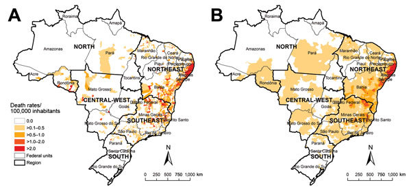
Spatial distribution of average annual crude (A) and Bayesian-smoothed (B) rates of schistosomiasis-related deaths, by municipality of residence, Brazil, 2000–2011. Empirical Bayesian smoothing estimates of rates of schistosomiasis-related deaths were performed by using TerraView software version 4.2 (Instituto Nacional de Pesquisas Espaciais, São Paulo, Brazil). Data were mapped by using ArcGIS software version 9.3 (Esri, Redlands, CA, USA). In 2010, Brazil was divided into 5 geographic regions (South, Southeast, Central-West, North, and Northeast), 27 Federal Units (26 states and 1 Federal District), and 5,565 municipalities.
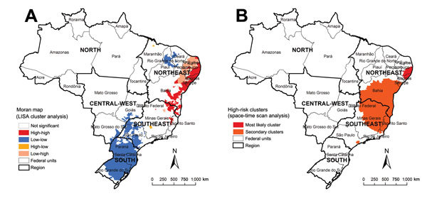
Spatial and spatiotemporal cluster analysis of rates of schistosomiasis-related deaths, by municipality of residence, Brazil, 2000–2011. A) LISA cluster analysis (Moran Map), based on Local Moran’s I index. B) Scan space-time clusters analysis, calculated by using Kulldorff’s scan statistics with SaTScan software version 9.1.1 (Harvard Medical School, Boston, MA, USA; Information Management Service, Silver Spring, MD, USA). Mapping and calculation of autocorrelation spatial analysis were conducted using ArcGIS software version 9.3 (Esri, Redlands, CA, USA). LISA, Local Index of Spatial Association.
References
-
- World Health Organization. Schistosomiasis. Geneva: The Organization. 2014. [cited 2014 Jul 05]. http://www.who.int/mediacentre/factsheets/fs115/en/
-
- Kloos H, Correa-Oliveira R, dos Reis DC, Rodrigues EW, Monteiro LA, Gazzinelli A. The role of population movement in the epidemiology and control of schistosomiasis in Brazil: a preliminary typology of population movement. Mem Inst Oswaldo Cruz. 2010;105:578–86. 10.1590/S0074-02762010000400038 - DOI - PubMed
Publication types
MeSH terms
LinkOut - more resources
Full Text Sources
Other Literature Sources