. 2015 Oct 20;112(42):13069-74.
doi: 10.1073/pnas.1501375112. Epub 2015 Oct 5.

Region-wide synchrony and traveling waves of dengue across eight countries in Southeast Asia

Affiliations

Region-wide synchrony and traveling waves of dengue across eight countries in Southeast Asia

Willem G van Panhuis et al. Proc Natl Acad Sci U S A. .

Abstract

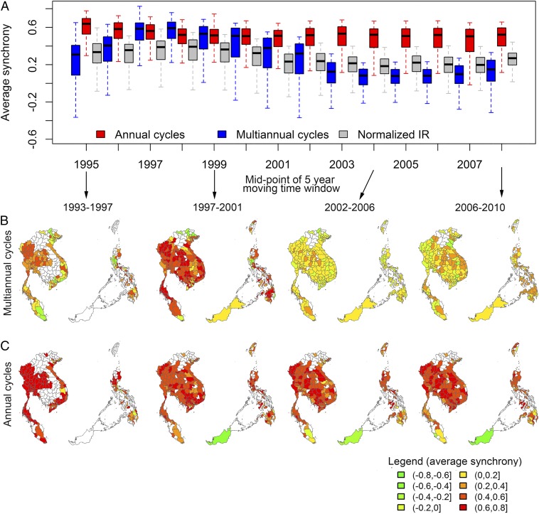
Dengue is a mosquito-transmitted virus infection that causes epidemics of febrile illness and hemorrhagic fever across the tropics and subtropics worldwide. Annual epidemics are commonly observed, but there is substantial spatiotemporal heterogeneity in intensity. A better understanding of this heterogeneity in dengue transmission could lead to improved epidemic prediction and disease control. Time series decomposition methods enable the isolation and study of temporal epidemic dynamics with a specific periodicity (e.g., annual cycles related to climatic drivers and multiannual cycles caused by dynamics in population immunity). We collected and analyzed up to 18 y of monthly dengue surveillance reports on a total of 3.5 million reported dengue cases from 273 provinces in eight countries in Southeast Asia, covering ∼ 10(7) km(2). We detected strong patterns of synchronous dengue transmission across the entire region, most markedly during a period of high incidence in 1997-1998, which was followed by a period of extremely low incidence in 2001-2002. This synchrony in dengue incidence coincided with elevated temperatures throughout the region in 1997-1998 and the strongest El Niño episode of the century. Multiannual dengue cycles (2-5 y) were highly coherent with the Oceanic Niño Index, and synchrony of these cycles increased with temperature. We also detected localized traveling waves of multiannual dengue epidemic cycles in Thailand, Laos, and the Philippines that were dependent on temperature. This study reveals forcing mechanisms that drive synchronization of dengue epidemics on a continental scale across Southeast Asia.

Keywords: Southeast Asia; dengue; dynamics; epidemiology; surveillance data.


Conflict of interest statement

The authors declare no conflict of interest.

Figures

Fig. 1.
Fig. 1.
Monthly dengue IRs (per 100,000 people) and longitudinal climate indicators. Monthly dengue IRs for each province ranked by latitude and monthly climate indicators for corresponding latitudes and time periods. Upper shows median values across provinces or latitudes. NA, not available. (A) Monthly dengue IRs per 100,000 people that have been centered and reduced into z scores, log10-transformed, detrended, and imputed. We imputed missing data by random draws from values of the same months but for different years (Fig. S3). (B) Map of the study provinces by latitude. (C) Average monthly temperature in degrees Celsius from gridded data covering the entire region averaged by latitude and centered and reduced into z scores. (D) The same as C but for total monthly precipitation (millimeters).
Fig. 2.
Fig. 2.
Wavelet transforms. Reconstructed periodic cycles of monthly dengue IRs for provinces ranked by latitude. Upper shows monthly distributions across provinces. NA, not available. (A) Reconstructed multiannual cycles. (B) Reconstructed annual cycles.
Fig. 3.
Fig. 3.
Synchrony of dengue cycles over time. We computed the average synchrony for moving, overlapping 5-y windows to detect changes over time. (A) Distributions of average synchrony per province per time window plotted at the midyear of each window for multiannual and annual cycles and unfiltered IRs. (B) The average synchrony of multiannual dengue cycles per province for four time windows. (C) The same as B but for annual cycles.
Fig. S1.
Fig. S1.
Changes in periodicity over time in months as shown by wavelet transforms and wavelet coherency. For each province, we computed the average power of statistically significant wavelet transforms per month in the multiannual or annual periodicity band. We also computed for each province the percentage of other provinces that had statistically significant wavelet coherency with this province. Upper shows monthly distributions. NA, not available. (A) Average power of statistically significant wavelet transforms in the multiannual periodicity band per month for each province ranked by latitude. (B) The same as A but for the annual periodicity band. (C) For each province ranked by latitude, the percentage of other provinces that had statistically significant wavelet coherency with this province for periodicities within the multiannual band. (D) The same as C but for the annual periodicity band.
Fig. S2.
Fig. S2.
Cross-correlation function of geographical distance vs. pairwise Pearson correlation. (A) Average cross-correlation functions (solid lines) and regional averages (dashed lines) of annual and multiannual cycles and log10 IRs centered and reduced to z scores. (B) Average cross-correlations and 95% CIs (solid lines) and the regional averages (dashed lines) for log10 IRs centered and reduced to z scores. (C) The same as B but for annual dengue cycles (6–18 mo). (D) The same as B but for multiannual dengue cycles (19–60 mo).
Fig. S3.
Fig. S3.
Dengue IRs and transformations. Monthly values for each province ranked by latitude in color coding. NA, not available. The distributions across provinces per month are shown in Upper. (A) Reported dengue IRs per 100,000 people. (B) Log10-transformed IRs. (C) Log10-transformed IRs that were detrended by subtracting fitted values of a linear model. (D) The same as in C but with missing data imputed.
Fig. 4.
Fig. 4.
Wavelet coherency between the ONI and multiannual DENV cycles. The monthly average statistically significant wavelet coherency between ONI and multiannual DENV cycles across (Lower) the multiannual periodicity band for each province ranked by latitude. Upper shows the distributions (medians and interquartile ranges) of province average wavelet coherency per month. NA, not available.
Fig. S4.
Fig. S4.
Average synchrony of multiannual dengue cycles between each of 10 major cities and all other provinces across the entire study period. We found two clusters of cities with different synchrony dependent on temperature. (A) Average synchrony of multiannual dengue cycles per province for cities that were not synchronous with the Annamite region. Two of the largest metropolitan areas, Manila and Ho Chi Minh City, had relatively low synchrony with most of the other provinces in the region, including the Annamite region, and are not shown. (B) Average annual temperature per province in degrees Celsius. (C) Average synchrony of multiannual dengue cycles per province for cities synchronous with the Annamite region.
Fig. 5.
Fig. 5.
Traveling waves of synchrony across provinces. For each province, we fitted a linear model of the phase difference θ of multiannual and annual dengue cycles vs. geographical distance (kilometers). A negative θ indicated that a province epidemic cycle was timed later than another province, possibly experiencing an incoming traveling wave (decreasing θ with decreasing distance). A positive θ indicated that a province was timed earlier than another province, possibly experiencing a positive traveling wave (increasing θ with increasing distance). For θ < 0, we inversed the distance for more intuitive displays. (A) Fitted values of linear models of θ for multiannual cycles vs. distance for each province. We fitted models separately for incoming and outgoing waves. Fitted values are only shown for provinces with a statistically significant model coefficient. We used a Bonferroni-corrected significance level (P < 2e−4) for each province but also, showed fitted values for models with significant coefficients at the 0.05 level (gray lines). The fitted values for the regional average model are shown as black lines. (B) The same as A but for annual cycles. (C) Provinces with statistically significant incoming (red) and outgoing (blue) waves of multiannual cycles. (D) The same as C but for annual cycles.
Fig. S5.
Fig. S5.
Monthly data available by province ranked by country. For each province, the months between 1993 and 2010 were included in the analysis for a total of 273 provinces. Upper shows the total number of provinces included per month. The length of the time series determined the maximum periodic cycle that could be studied by wavelet analysis. To reduce edge effects, we defined the maximum periodicity for each province as the number of observations divided by 2.5 (i.e., the time series should be able to contain at least 2.5 repeats of a periodic cycle).
Fig. S6.
Fig. S6.
Sensitivity analysis of average synchrony per province for different values of ω0 and δj. We reconstructed multiannual and annual cycles using different values for the wavelet parameters ω0 and δj and recomputed the average correlation coefficient per province weighted by the number of province pairs with non-missing data. We used an ω0 of 6 and a δj of 0.25 in our analysis. NA, not available. (A) Average synchrony of multiannual cycles for values of ω0. (B) The same as A for annual cycles. (C) Average synchrony of multiannual cycles for values of δj. (D) The same as C for annual cycles.
Fig. S7.
Fig. S7.
Variance explained by different periodicities for each province. We used wavelet analysis for periodicities ranging from 2 mo to the maximum periodicity for a province, with a 1-mo step size along a linear scale. (A) The global wavelet power spectrum using only statistically significant wavelet transforms per province ranked by latitude. Upper shows the distributions across provinces. NA, not available. (B) The average multiannual periodicity across periodicities ranging from 19 to the maximum supported by a province time series weighted by the average power for each periodicity.
Fig. S8.
Fig. S8.
Local traveling waves for Bangkok and four hypothetical example provinces. (A) Location of Bangkok and four hypothetical provinces at varying distances. (B) IRs (per 100,000 people) for each location. (C) Wavelet reconstruction of multiannual (19–60 m) dengue cycles. (D) Phase angles of multiannual dengue cycles. (E) Linear model fit of the association between lag time in months and geographical distance from Bangkok. For negative phase angle differences, we inversed the geographical distance for a more intuitive display. Incoming traveling waves into Bangkok were defined as decreasing lag times with decreasing distance (other provinces timed ahead of Bangkok). Outgoing waves emerging from Bangkok were defined as increasing lag times with increasing geographical distance (other provinces timed after Bangkok). We measured the presence of these incoming or outgoing traveling waves for each province in our study (Fig. 5).

References

    1. Bhatt S, et al. The global distribution and burden of dengue. Nature. 2013;496(7446):504–507. - PMC - PubMed
    1. Grenfell BT, Bjørnstad ON, Kappey J. Travelling waves and spatial hierarchies in measles epidemics. Nature. 2001;414(6865):716–723. - PubMed
    1. Viboud C, et al. Synchrony, waves, and spatial hierarchies in the spread of influenza. Science. 2006;312(5772):447–451. - PubMed
    1. Rohani P, Earn DJ, Grenfell BT. Opposite patterns of synchrony in sympatric disease metapopulations. Science. 1999;286(5441):968–971. - PubMed
    1. Teurlai M, et al. Can human movements explain heterogeneous propagation of dengue fever in Cambodia? PLoS Negl Trop Dis. 2012;61(12):e1957. - PMC - PubMed

Publication types

LinkOut - more resources