Spatial Analysis of Anthropogenic Landscape Disturbance and Buruli Ulcer Disease in Benin
- PMID: 26474482
- PMCID: PMC4608567
- DOI: 10.1371/journal.pntd.0004123
Spatial Analysis of Anthropogenic Landscape Disturbance and Buruli Ulcer Disease in Benin
Abstract
Background: Land use and land cover (LULC) change is one anthropogenic disturbance linked to infectious disease emergence. Current research has focused largely on wildlife and vector-borne zoonotic diseases, neglecting to investigate landscape disturbance and environmental bacterial infections. One example is Buruli ulcer (BU) disease, a necrotizing skin disease caused by the environmental pathogen Mycobacterium ulcerans (MU). Empirical and anecdotal observations have linked BU incidence to landscape disturbance, but potential relationships have not been quantified as they relate to land cover configurations.
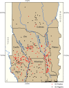
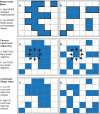
Methodology/principal findings: A landscape ecological approach utilizing Bayesian hierarchical models with spatial random effects was used to test study hypotheses that land cover configurations indicative of anthropogenic disturbance were related to Buruli ulcer (BU) disease in southern Benin, and that a spatial structure existed for drivers of BU case distribution in the region. A final objective was to generate a continuous, risk map across the study region. Results suggested that villages surrounded by naturally shaped, or undisturbed rather than disturbed, wetland patches at a distance within 1200 m were at a higher risk for BU, and study outcomes supported the hypothesis that a spatial structure exists for the drivers behind BU risk in the region. The risk surface corresponded to known BU endemicity in Benin and identified moderate risk areas within the boundary of Togo.
Conclusions/significance: This study was a first attempt to link land cover configurations representative of anthropogenic disturbances to BU prevalence. Study results identified several significant variables, including the presence of natural wetland areas, warranting future investigations into these factors at additional spatial and temporal scales. A major contribution of this study included the incorporation of a spatial modeling component that predicted BU rates to new locations without strong knowledge of environmental factors contributing to disease distribution.
Conflict of interest statement
The authors have declared that no competing interests exist.
Figures


Similar articles
-
Buruli ulcer disease prevalence in Benin, West Africa: associations with land use/cover and the identification of disease clusters.Int J Health Geogr. 2008 May 27;7:25. doi: 10.1186/1476-072X-7-25. Int J Health Geogr. 2008. PMID: 18505567 Free PMC article.
-
Detection of Mycobacterium ulcerans in the environment predicts prevalence of Buruli ulcer in Benin.PLoS Negl Trop Dis. 2012 Jan;6(1):e1506. doi: 10.1371/journal.pntd.0001506. Epub 2012 Jan 31. PLoS Negl Trop Dis. 2012. PMID: 22303498 Free PMC article.
-
A Landscape-based model for predicting Mycobacterium ulcerans infection (Buruli Ulcer disease) presence in Benin, West Africa.Ecohealth. 2008 Mar;5(1):69-79. doi: 10.1007/s10393-007-0148-7. Epub 2008 Feb 8. Ecohealth. 2008. PMID: 18648799
-
The Buruli Ulcer.Int J Low Extrem Wounds. 2015 Sep;14(3):217-23. doi: 10.1177/1534734615599653. Epub 2015 Aug 18. Int J Low Extrem Wounds. 2015. PMID: 26286931 Review.
-
Buruli ulcer (Mycobacterium ulcerans infection).Trans R Soc Trop Med Hyg. 2008 Oct;102(10):969-78. doi: 10.1016/j.trstmh.2008.06.006. Epub 2008 Jul 26. Trans R Soc Trop Med Hyg. 2008. PMID: 18657836 Review.
Cited by
-
Perception and incidence of Buruli ulcer in Ogun State, South West Nigeria: intensive epidemiological survey and public health intervention recommended.Pan Afr Med J. 2018 Mar 22;29:166. doi: 10.11604/pamj.2018.29.166.10110. eCollection 2018. Pan Afr Med J. 2018. PMID: 30050630 Free PMC article.
-
Landscape and environmental influences on Mycobacterium ulcerans distribution among aquatic sites in Ghana.PLoS One. 2017 Apr 24;12(4):e0176375. doi: 10.1371/journal.pone.0176375. eCollection 2017. PLoS One. 2017. PMID: 28437439 Free PMC article.
-
Global and local environmental changes as drivers of Buruli ulcer emergence.Emerg Microbes Infect. 2017 Apr 26;6(4):e21. doi: 10.1038/emi.2017.7. Emerg Microbes Infect. 2017. PMID: 28442755 Free PMC article. Review.
-
Impact of Temperature and Oxygen Availability on Gene Expression Patterns of Mycobacterium ulcerans.Microbiol Spectr. 2023 Mar 13;11(2):e0496822. doi: 10.1128/spectrum.04968-22. Online ahead of print. Microbiol Spectr. 2023. PMID: 36912651 Free PMC article.
-
Mapping suitability for Buruli ulcer at fine spatial scales across Africa: A modelling study.PLoS Negl Trop Dis. 2021 Mar 3;15(3):e0009157. doi: 10.1371/journal.pntd.0009157. eCollection 2021 Mar. PLoS Negl Trop Dis. 2021. PMID: 33657104 Free PMC article.
References
-
- Patz J, Confalonieri U (2005) Human Health: Ecosystem regulation of infectious diseases Ecosystems and Human Well-being: Current State and Trends: Findings of the Condition and Trends Working Group of the Millennium Ecosystem Assessment, Washington, DC: Hassan R, Scholes R, Ash N, editors. Island Press; 391–415 p.
-
- Aguirre AA (2002) Conservation Medicine: Ecological health in practice. Oxford; New York: Oxford University Press; xxiv, 407 p. p.
Publication types
MeSH terms
Grants and funding
LinkOut - more resources
Full Text Sources
Other Literature Sources
Research Materials

