. 2015 Aug 1;38(8):769-781.
doi: 10.1111/ecog.01327. Epub 2015 Feb 25.

Climate as a driver of tropical insular diversity: comparative phylogeography of two ecologically distinctive frogs in Puerto Rico

Affiliations

Climate as a driver of tropical insular diversity: comparative phylogeography of two ecologically distinctive frogs in Puerto Rico

Brittany S Barker et al. Ecography. .

Abstract

The effects of late Quaternary climate on distributions and evolutionary dynamics of insular species are poorly understood in most tropical archipelagoes. We used ecological niche models under past and current climate to derive hypotheses regarding how stable climatic conditions shaped genetic diversity in two ecologically distinctive frogs in Puerto Rico. Whereas the Mountain Coquí, Eleutherodactylus portoricensis, is restricted to montane forest in the Cayey and Luquillo Mountains, the Red-eyed Coquí, E. antillensis, is a habitat generalist distributed across the entire Puerto Rican Bank (Puerto Rico and the Virgin Islands, excluding St. Croix). To test our hypotheses, we conducted phylogeographic and population genetic analyses based on mitochondrial and nuclear loci of each species across their range in Puerto Rico. Patterns of population differentiation in E. portoricensis, but not in E. antillensis, supported our hypotheses. For E. portoricensis, these patterns include: individuals isolated by long-term unsuitable climate in the Río Grande de Loíza Basin in eastern Puerto Rico belong to different genetic clusters; past and current climate strongly predicted genetic differentiation; and Cayey and Luquillo Mountains populations split prior to the last interglacial. For E. antillensis, these patterns include: genetic clusters did not fully correspond to predicted long-term unsuitable climate; and past and current climate weakly predicted patterns of genetic differentiation. Genetic signatures in E. antillensis are consistent with a recent range expansion into western Puerto Rico, possibly resulting from climate change and anthropogenic influences. As predicted, regions with a large area of long-term suitable climate were associated with higher genetic diversity in both species, suggesting larger and more stable populations. Finally, we discussed the implications of our findings for developing evidence-based management decisions for E. portoricensis, a taxon of special concern. Our findings illustrate the role of persistent suitable climatic conditions in promoting the persistence and diversification of tropical island organisms.


Figures

Figure 1
Figure 1
Map of Puerto Rico showing the topography of the island and the geographic origins of the Eleutherodactylus portoricensis (triangles) and E. antillensis (circles) samples included in our genetic analyses. The Central Mountains (=Cordillera Central), the Cayey Mountains (=Sierra de Cayey; a southeastern extension of the Central Mountains), the Río Grande de Loíza, and the Luquillo Mountains (=Sierra de Luquillo) are indicated. The dotted line depicts the approximate distribution of the Río Grande de Loíza Basin.
Figure 2
Figure 2
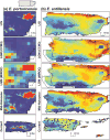
Logistic output of ecological niche models (ENMs) for (a) Eleutherodactylus portoricensis and (b) E. antillensis in Puerto Rico under last interglacial (LIG), last glacial maximum [under CCSM3 [LGM (CCSM3)] and MIROC [LGM (MIROC) scenarios], mid-Holocene, and current climatic conditions. Warmer colours represent areas of higher climatic suitability. Geographic locations used for ecological niche modeling are depicted in ENMs under current climate. The inset on Puerto Rico's map (top left) shows the study area for E. portoricensis.
Figure 3
Figure 3
Map showing the long-term climatic suitability surfaces for (a) Eleutherodactylus portoricensis (b) and E. antillensis, calculated as the sum of climatic suitability pixels under last interglacial (LIG), last glacial maximum (LGM), mid-Holocene, and current climatic conditions. Two surfaces for each species are shown to illustrate CCSM3 (top) and MIROC (bottom) scenarios of LGM climatic conditions. Long-term climatic suitability surface values are presented in four groups of equal size (i.e. quartiles). The inset on Puerto Rico's map (top left) shows the study area for E. portoricensis. Dotted lines represent the division used to define regional populations (western and eastern Puerto Rico) of E. antillensis for testing the hypothesis that genetic diversity is higher in areas with a larger region of suitable climate over the LIG, LGM, mid-Holocene, and present-day periods. The Central Mountains (=Cordillera Central), the Cayey Mountains (=Sierra de Cayey; a southeastern extension of the Central Mountains), the Río Grande de Loíza, and the Luquillo Mountains (=Sierra de Luquillo), and the geographic origins of the E. portoricensis and E. antillensis samples included in our genetic analyses are indicated.
Figure 4
Figure 4
Maps of the study areas for (a) Eleutherodactylus portoricensis and (b, c) E. antillensis in Puerto Rico, illustrating the results of STRUCTURE analyses of four nuDNA intron loci (CRYBA, MYH, RH1, and RPL9int4) under a model of correlated allele frequencies, and the conductance surfaces estimated from ecological niche models under last interglacial, last glacial maximum (CCSM3 scenario), mid-Holocene, and current climatic conditions. The conductance surface for E. antillensis is shown twice to illustrate results from a STRUCTURE analysis based on the models of (b) admixture and (c) no-admixture. Pie charts depict the mean membership fractions of individuals at each sampling locality in relation to a genetic cluster inferred by STRUCTURE analyses. To prevent overlap of pie charts, we used black leader lines to indicate the geographic location of nearby sampling localities. Bar plots are shown for the best estimate of K, where K is the number of genetic clusters. Each vertical bar shows the proportional representation of the estimated cluster membership for a single individual, and is sorted by the latitude and longitude of its locality. The location of the Río Grande de Loíza is indicated.

Similar articles

Cited by

References

    1. Angulo A. Eleutherodactylus portoricensis. IUCN 2013 IUCN Red List of Threatened Species Version 2013.2. 2008 www.iucnredlist.org. Downloaded on 06 May 2014.
    1. Austerlitz F, et al. Evolution of coalescence times, genetic diversity and structure during colonization. Theor Popul Biol. 1997;51:148–164.
    1. Barker BS, Ríos-Franceschi A. Population declines of Mountain Coqui (Eleutherodactylus portoricensis) in the Cordillera Central of Puerto Rico. Herp Cons Biol in press. - PMC - PubMed
    1. Barker BS, et al. Sea level, topography, and island diversity: phylogeography of the Puerto Rican Red-eyed Coquí, Eleutherodactylus antillensis. Mol Ecol. 2012;21:6033–6052. - PubMed
    1. Barker BS, et al. Deep intra-island divergence of a montane forest endemic: phylogeography of the Puerto Rican frog Eleutherodactylus portoricensis (Anura: Eleutherodactylidae) J Biogeogr. 2011;38:2311–2325.