. 2015 Oct 30;1(9):e1500852.
doi: 10.1126/sciadv.1500852. eCollection 2015 Oct.

Lunar impact basins revealed by Gravity Recovery and Interior Laboratory measurements

Affiliations

Lunar impact basins revealed by Gravity Recovery and Interior Laboratory measurements

Gregory A Neumann et al. Sci Adv. .

Abstract

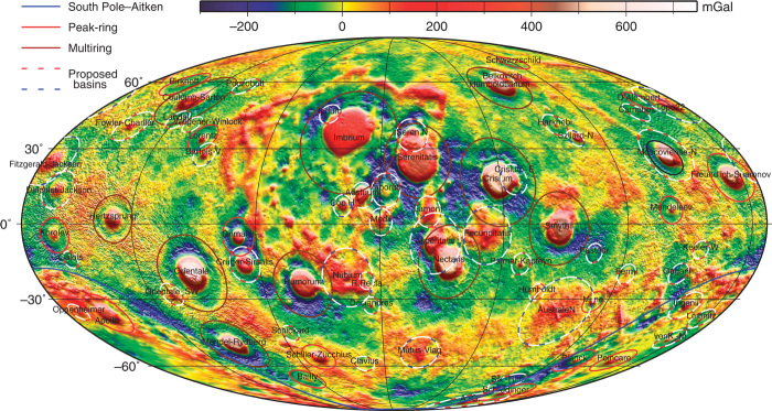
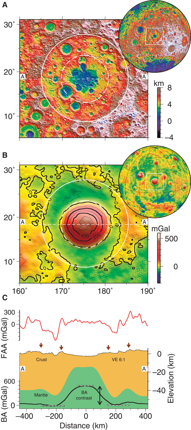
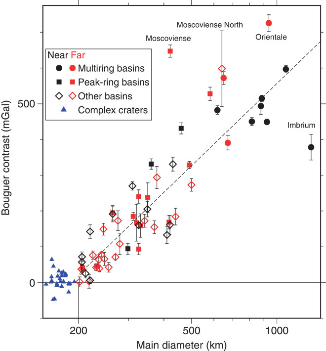
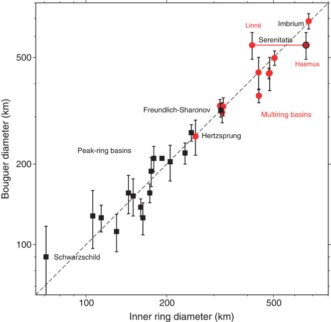
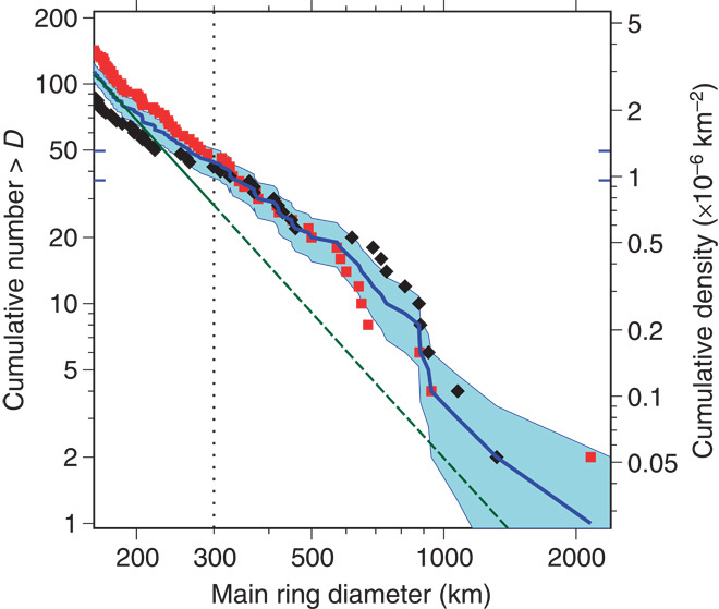
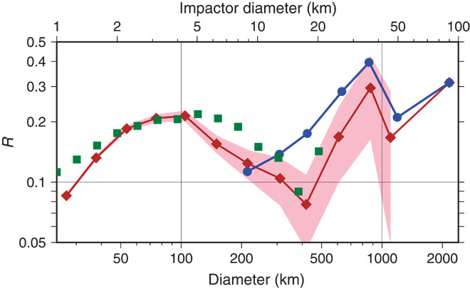
Observations from the Gravity Recovery and Interior Laboratory (GRAIL) mission indicate a marked change in the gravitational signature of lunar impact structures at the morphological transition, with increasing diameter, from complex craters to peak-ring basins. At crater diameters larger than ~200 km, a central positive Bouguer anomaly is seen within the innermost peak ring, and an annular negative Bouguer anomaly extends outward from this ring to the outer topographic rim crest. These observations demonstrate that basin-forming impacts remove crustal materials from within the peak ring and thicken the crust between the peak ring and the outer rim crest. A correlation between the diameter of the central Bouguer gravity high and the outer topographic ring diameter for well-preserved basins enables the identification and characterization of basins for which topographic signatures have been obscured by superposed cratering and volcanism. The GRAIL inventory of lunar basins improves upon earlier lists that differed in their totals by more than a factor of 2. The size-frequency distributions of basins on the nearside and farside hemispheres of the Moon differ substantially; the nearside hosts more basins larger than 350 km in diameter, whereas the farside has more smaller basins. Hemispherical differences in target properties, including temperature and porosity, are likely to have contributed to these different distributions. Better understanding of the factors that control basin size will help to constrain models of the original impactor population.

Keywords: GRAIL Discovery Mission; Gravity Recovery and Interior Laboratory Mission; late heavy bombardment; lunar geophysics; lunar impact basins; size-frequency distribution.


Figures

Fig. 1
Fig. 1. Bouguer anomaly map for the Moon.
A color-contoured map of the Bouguer-corrected GRAIL gravity anomaly, in Mollweide equal-area projection centered on the nearside at 7°E longitude, band-passed between ~10- and 900-km block size and hill-shaded from above. The Bouguer anomaly scale is in mGal (milliGalileo; 10−5 m s−2). Over spherical harmonic degrees 6 to 540, the band-pass window predominantly removes the effect of the hemispheric asymmetry and the South Pole–Aitken impact and allows identification of impact basins up to the size of Imbrium. Red/white circles show proposed basins having only one topographic ring and no interior peak ring or central peak but a gravity signature similar to those of peak-ring basins. Blue-white circles outline basins that lack a clearly defined topographic rim crest but that are suggested by gravity anomaly patterns to be basins (see the Supplementary Materials for details).
Fig. 2
Fig. 2. Freundlich-Sharonov basin.
(A) Topography of this farside peak-ring basin is shown over shaded relief. Inset: Location of the region. Solid (582-km-diameter) and dashed (318-km-diameter) circles mark the rim crest or main ring and inner peak ring, respectively. (B) Bouguer gravity anomaly map band-passed between ~10- and 900-km block size, directionally shaded. The Bouguer gravity anomaly contour interval is 100 mGal. (C) Cross-sectional diagram of the topography, free-air anomaly (FAA), Bouguer anomaly (BA), and crustal structure (23) along profile A–A′. Vertical exaggeration (VE) is 6:1. Arrows denote the locations of the outer rim crest and inner peak ring. Dashed lines illustrate Bouguer contrast between spatial averages over the central (from 0 to 20% of the rim radius) and annular (50 to 100%) regions.
Fig. 3
Fig. 3. Bouguer anomaly contrast versus main ring diameter (log scale).
Symbols show complex craters >160 km in diameter (blue triangles), nearside basins (black symbols), and farside basins (red symbols). Open symbols represent possible basins in which multiple rings are not preserved. The rate of increase in Bouguer anomaly contrast given by a log-linear least-squares fit to diameter (dashed line) is about 240 mGal per factor of 2 increase in diameter. Moscoviense is believed to be a double impact (41) and is plotted as two separate points, Moscoviense and Moscoviense North.
Fig. 4
Fig. 4. Diameter of the central positive Bouguer anomaly versus diameter of the peak ring or inner topographic ring.
The 16 peak-ring (black) and 11 multiring (red) basins identified in this and previous studies (7) are shown. Identification of the inner ring of the Serenitatis basin (fig. S1) is uncertain owing to later modification. Both a 660-km-diameter Haemus ring and a 420-km-diameter Linné ring (both named for topographic features along the rings) are shown connected by a red line. The dashed line indicates a 1:1 ratio.
Fig. 5
Fig. 5. Cumulative size-frequency distribution for complex craters and basins.
The blue line shows data for all the craters and basins in Table 1. The shaded region spans the 1-SD error estimates. Black diamonds and red squares show the cumulative size-frequency distributions for nearside and farside craters, respectively, normalized by area; for these symbols, the cumulative number scale on the left reads two times the value. Short horizontal blue lines show confidence limits of N(300) for the overall population. The cumulative Hartmann production function (30) for craters larger than 64 km is shown by the green line with a slope of −2.2, extrapolated for diameters larger than 300 km (vertical dotted line). The main ring diameter was inferred from the diameter of the central Bouguer anomaly high for basins observed in GRAIL data that lack an outer topographic rim.
Fig. 6
Fig. 6. Relative size-frequency distribution of lunar craters and basins.
Logarithmic plot of relative frequency R of craters in this study (blue circles) versus the geometric mean d of diameters in each size bin. Bin boundaries from b1 to b2 containing N craters range from 24.5 to 211.5 km by multiples of √2. The frequencies are normalized to R = d3N/[A(b2b1)], where A is the surface area of the Moon. The data set in this study contains substantially more features of a given size than the database of Head et al. (6) (brown diamonds, 1-SD confidence shaded in pink), except in the interval centered on 214 km where the “Keeler-Heaviside” and “TOPO-19” features did not meet our criteria for inclusion. Green squares illustrate the size distribution of main-belt asteroids from the Sloan Digital Sky Survey [after Strom et al. (38), Fig. 4], normalized in scale to match the relative values of the lunar crater population at a diameter of 100 km.

References

    1. Hartmann W. K., Kuiper G. P., Concentric structures surrounding lunar basins. Commun. Lunar Planet. Lab. 1, 51–66 (1962).
    1. Hartmann W. K., Wood C. W., Moon: Origin and evolution of multi-ring basins. Moon 3, 3–78 (1971).
    1. Pike R. J., Depth/diameter relations of fresh lunar craters: Revision from spacecraft data. Geophys. Res. Lett. 1, 291–294 (1974).
    1. P. D. Spudis, The Geology of Multi-ring Basins (Cambridge Univ. Press, Cambridge, 1993).
    1. D. E. Wilhelms, The Geologic History of the Moon (U.S. Geological Survey Professional Paper 1348, Government Printing Office, Washington, DC, 1987).

LinkOut - more resources