

Tracking Vaccination Teams During Polio Campaigns in Northern Nigeria by Use of Geographic Information System Technology: 2013-2015
- PMID: 26609004
- PMCID: PMC4818548
- DOI: 10.1093/infdis/jiv493
Tracking Vaccination Teams During Polio Campaigns in Northern Nigeria by Use of Geographic Information System Technology: 2013-2015
Abstract
Introduction: Nigeria is among the 3 countries in which polio remains endemic. The country made significant efforts to reduce polio transmission but remains challenged by poor-quality campaigns and poor team performance in some areas. This article demonstrates the application of geographic information system technology to track vaccination teams to monitor settlement coverage, reduce the number of missed settlements, and improve team performance.
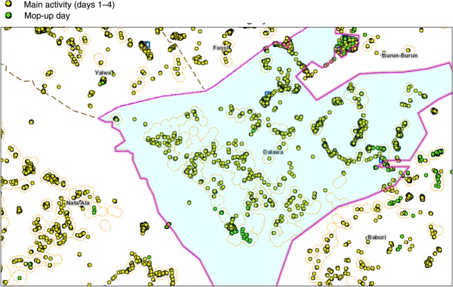
Methods: In each local government area where tracking was conducted, global positioning system-enabled Android phones were given to each team on a daily basis and were used to record team tracks. These tracks were uploaded to a dashboard to show the level of coverage and identify areas missed by the teams.
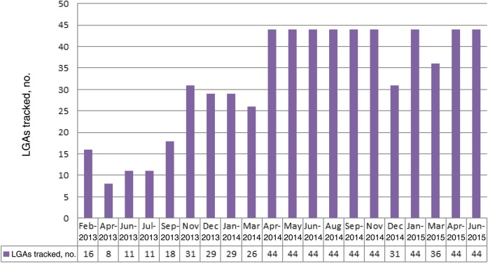
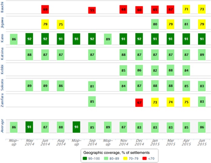
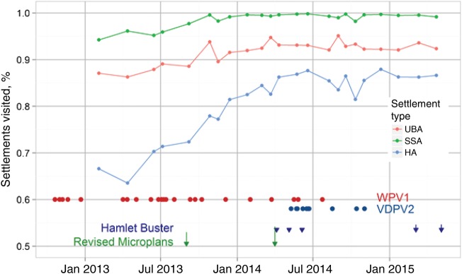
Results: From 2012 to June 2015, tracking covered 119 immunization days. A total of 1149 tracking activities were conducted. Of these, 681 (59%) were implemented in Kano state. There was an improvement in the geographic coverage of settlements and an overall reduction in the number of missed settlements.
Conclusions: The tracking of vaccination teams provided significant feedback during polio campaigns and enabled supervisors to evaluate performance of vaccination teams. The reports supported other polio program activities, such as review of microplans and the deployment of other interventions, for increasing population immunity in northern Nigeria.
Keywords: dashboard; geographic coverage of settlements; team performance; tracking vaccination teams.
© 2016 World Health Organization; licensee Oxford Journals.
Figures
References
-
- World Health Organization. Poliomyelitis. Fact sheet no. 114 October 2014. http://www.who.int/mediacentre/factsheets/fs114/en/ Accessed 10 June 2015.
-
- Morrison AC, Getis A, Santiago M, Rigau-Perez JG, Reiter P. Exploratory space-time analysis of reported dengue cases during an outbreak in Florida, Puerto Rico, 1991–1992. Am J Trop Med Hyg 1998; 58:287–98. - PubMed
-
- Munch Z, Van Lill SW, Booysen CN, Zietsman HL, Enarson DA, Beyers N. Tuberculosis transmission patterns in a high-incidence area: a spatial analysis. Int J Tuberc Lung Dis 2003; 7:271–7. - PubMed
Publication types
MeSH terms
Substances
Grants and funding
LinkOut - more resources
Full Text Sources
Other Literature Sources
Medical
