

Global positioning system & Google Earth in the investigation of an outbreak of cholera in a village of Bengaluru Urban district, Karnataka
- PMID: 26658586
- PMCID: PMC4743338
- DOI: 10.4103/0971-5916.171277
Global positioning system & Google Earth in the investigation of an outbreak of cholera in a village of Bengaluru Urban district, Karnataka
Abstract
Background & objectives: The global positioning system (GPS) technology along with Google Earth is used to measure (spatial map) the accurate distribution of morbidity, mortality and planning of interventions in the community. We used this technology to find out its role in the investigation of a cholera outbreak, and also to identify the cause of the outbreak.
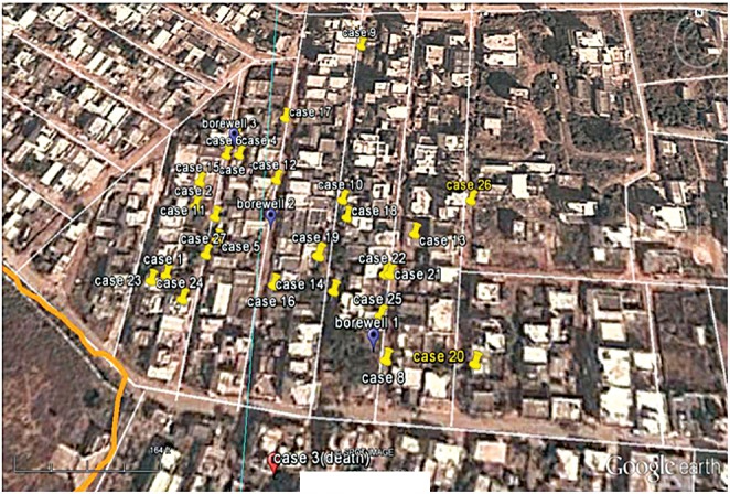
Methods: This study was conducted in a village near Bengaluru, Karnataka in June 2013 during a cholera outbreak. House-to-house survey was done to identify acute watery diarrhoea cases. A hand held GPS receiver was used to record north and east coordinates of the households of cases and these values were subsequently plotted on Google Earth map. Water samples were collected from suspected sources for microbiological analysis.
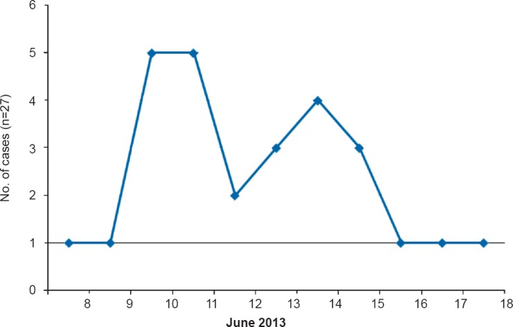
Results: A total of 27 cases of acute watery diarrhoea were reported. Fifty per cent of cases were in the age group of 14-44 yr and one death was reported. GPS technology and Google Earth described the accurate location of household of cases and spot map generated showed clustering of cases around the suspected water sources. The attack rate was 6.92 per cent and case fatality rate was 3.7 per cent. Water samples collected from suspected sources showed the presence of Vibrio cholera O1 Ogawa.
Interpretation & conclusions: GPS technology and Google Earth were easy to use, helpful to accurately pinpoint the location of household of cases, construction of spot map and follow up of cases. Outbreak was found to be due to contamination of drinking water sources.
Conflict of interest statement
Figures
Comment in
-
Mapping of cholera cases using satellite based recording systems to investigate the outbreak.Indian J Med Res. 2015 Nov;142(5):509-11. doi: 10.4103/0971-5916.171269. Indian J Med Res. 2015. PMID: 26658582 Free PMC article. No abstract available.
References
-
- Vol. 90. Geneva, Switzerland: WHO; 2015. [accessed on November 10, 2015]. World Health Organization (WHO). Weekly Epidemiological Record, No. 40; pp. 517–44. Available from: http://www.who.int/wer/2015/wer9040/en .
-
- Bangalore: Government of Karnataka; 2004. Directorate of Health and Family Welfare, Karnataka. Notes on surveillance, prevention of communicable diseases; pp. 21–9.
-
- New Delhi: DGHS, Government of India; 2005. Directorate General of Health Services (DGHS), Government of India. Integrated disease surveillance project. Training manual for state & district surveillance officers; pp. 71–2.
MeSH terms
LinkOut - more resources
Full Text Sources
Other Literature Sources
Medical