. 2016 Jan 28;374(2059):20140306.
doi: 10.1098/rsta.2014.0306.

Recent advances in understanding Antarctic subglacial lakes and hydrology

Affiliations

Recent advances in understanding Antarctic subglacial lakes and hydrology

Martin J Siegert et al. Philos Trans A Math Phys Eng Sci. .

Abstract

It is now well documented that over 400 subglacial lakes exist across the bed of the Antarctic Ice Sheet. They comprise a variety of sizes and volumes (from the approx. 250 km long Lake Vostok to bodies of water less than 1 km in length), relate to a number of discrete topographic settings (from those contained within valleys to lakes that reside in broad flat terrain) and exhibit a range of dynamic behaviours (from 'active' lakes that periodically outburst some or all of their water to those isolated hydrologically for millions of years). Here we critique recent advances in our understanding of subglacial lakes, in particular since the last inventory in 2012. We show that within 3 years our knowledge of the hydrological processes at the ice-sheet base has advanced considerably. We describe evidence for further 'active' subglacial lakes, based on satellite observation of ice-surface changes, and discuss why detection of many 'active' lakes is not resolved in traditional radio-echo sounding methods. We go on to review evidence for large-scale subglacial water flow in Antarctica, including the discovery of ancient channels developed by former hydrological processes. We end by predicting areas where future discoveries may be possible, including the detection, measurement and significance of groundwater (i.e. water held beneath the ice-bed interface).

Keywords: Antarctica; basal processes; ice flow; ice sheet.


Figures

Figure 1.
Figure 1.
Geophysical investigations of ‘active’ subglacial lake Institute E2. (a) Subglacial topography of the Institute Ice Stream region (with insert for the study region in West Antarctica) [34]. The grounding line is provided in white. Elevations are in metres above WGS84. (b) Ice-surface elevation with RES (grey lines) [35] and ICESat transects (black dotted lines) over and around Institute E2 (dashed line), as delineated by Smith et al. [27]. RES lines in black and labelled A–A’, B–B’ and C–C’ refer to RES transects provided in figure 2. Elevations are in metres above WGS84. (Adapted from Siegert et al. [33].)
Figure 2.
Figure 2.
RES transects centred on Institute E2. The locations of the transects are provided in figure 1b. (a) Transect A–A’, (b) transect B–B’ and (c) transect C–C’. For each transect, the coverage of the ICESat-derived lake extent (after [27]) is shown as a white bar on the radargram. Beneath the radargrams graphs of ice-surface elevation (m WGS84), bed elevation (m WGS84), basal hydropotential and basal reflectivity are provided. (Adapted from Siegert et al. [33].)
Figure 3.
Figure 3.
The subglacial hydrology of the Aurora Subglacial Basin area, including the locations of subglacial lakes (triangles) and sites of ice-surface elevation change interpreted as subglacial water movements (purple circles). Sites that do not resemble substantial lakes in RES data, but are identified by an automated algorithm for detecting subglacial water, are also shown as red dots. The extent of the predicted flow paths of subglacial water is limited to areas of subglacial topography at the pressure melting point. Subglacial lakes with numbers relate to new lakes discovered since the last full inventory [12]. (Adapted from Wright et al. [13].)
Figure 4.
Figure 4.
Ice-shelf surface channels visible on the MODIS Mosaic of Antarctica, overlain by calculations of subglacial meltwater flux. (a) Filchner–Ronne Ice Shelf; the arrowed features are downstream of (left to right) Institute, Moller, Foundation and Support Force Ice Streams. (b) MacAyeal Ice Stream, flowing into the Ross Ice Shelf. (cd) A series of small East Antarctic ice shelves. (e) Lambert Glacier, which flows into the Amery Ice Shelf. Black arrowshighlight ice-shelf surface channel features. Orange circles indicate evidence of migration of the exit point of subglacial channels. The green line is the MODIS-derived ice-sheet grounding line. Dashed lines on (a) are airborne RES flightlines. (Adapted from Le Brocq et al. [42].)
Figure 5.
Figure 5.
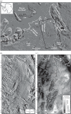
(a) MODIS satellite imagery [46] revealing the location of the inner Weddell Sea Embayment, West Antarctica. Black box marks the extent of panels (b,c). (b) Linear surface features identified in MODIS imagery. (c) Subglacial topography overlain with channel locations (white lines) observed in (b). White diamonds identify subglacial channels that are visible in both the MODIS imagery and in RES data. Black diamonds mark channels only visible in RES data. The black dashed line is the 0 m elevation contour. Solid black lines denote the Marginal Basins (−650 m contour). Annotations are provided as follows: BI, Berkner Island; BIR, Bungenstock Ice Rise; DIR, Doake Ice Rumples; FlP, Fletcher Promontory; FoP, Fowler Peninsula; FIS, Foundation Ice Stream; HIR, Henry Ice Rise; KIR, Korff Ice Rise; MIS, Möller Ice Stream; PN, Pagano Nunatak; SH, Stewart Hills; SIR, Skytrain Ice Rise; TB, Transitional Basins; TT, Thiel Trough (southern edge). (Adapted from Rose et al. [47].)

References

    1. Robin G de Q, Evans S, Bailey JT. 1969. Interpretation of radio echo sounding in polar ice sheets. Phil. Trans. R. Soc. Lond. A 265, 437–505. (10.1098/rsta.1969.0063) - DOI
    1. Turchetti S, Dean K, Naylor S, Siegert M. 2008. Accidents and opportunities: a history of the radio echo sounding (RES) of Antarctica, 1958–1979. Br. J. Hist. Sci. 41, 417–444. (10.1017/S0007087408000903) - DOI
    1. Oswald GKA, Robin G de Q. 1973. Lakes beneath the Antarctic Ice Sheet. Nature 245, 251–254. (10.1038/245251a0) - DOI
    1. Robin G de Q, Drewry DJ, Meldrum DT. 1977. International studies of ice sheet and bedrock. Phil. Trans. R. Soc. Lond. A 279, 185–196. (10.1098/rstb.1977.0081) - DOI
    1. Shreve RL. 1972. Movement of water in glaciers. J. Glaciol. 11, 205–214.

Publication types