. 2016 Jan 19;11(1):e0146543.
doi: 10.1371/journal.pone.0146543. eCollection 2016.

Limitations to the Use of Species-Distribution Models for Environmental-Impact Assessments in the Amazon

Affiliations

Limitations to the Use of Species-Distribution Models for Environmental-Impact Assessments in the Amazon

Lorena Ribeiro de A Carneiro et al. PLoS One. .

Abstract

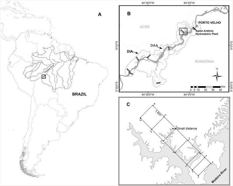
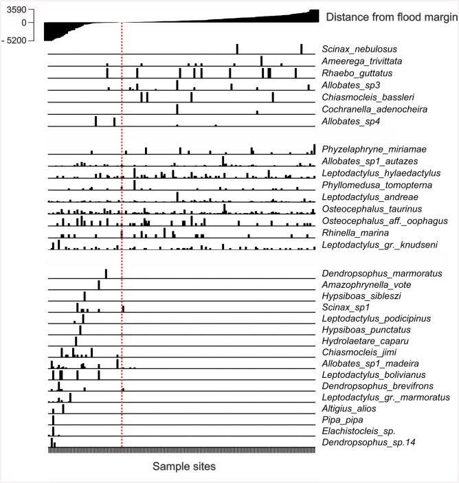
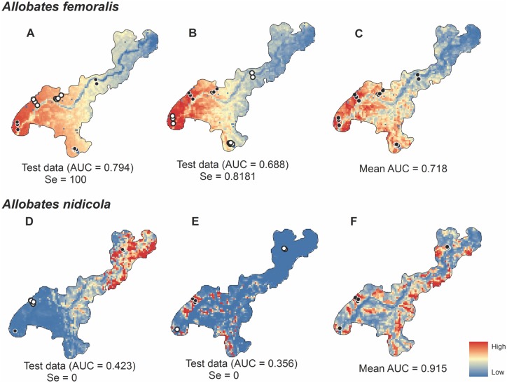
Species-distribution models (SDM) are tools with potential to inform environmental-impact studies (EIA). However, they are not always appropriate and may result in improper and expensive mitigation and compensation if their limitations are not understood by decision makers. Here, we examine the use of SDM for frogs that were used in impact assessment using data obtained from the EIA of a hydroelectric project located in the Amazon Basin in Brazil. The results show that lack of knowledge of species distributions limits the appropriate use of SDM in the Amazon region for most target species. Because most of these targets are newly described and their distributions poorly known, data about their distributions are insufficient to be effectively used in SDM. Surveys that are mandatory for the EIA are often conducted only near the area under assessment, and so models must extrapolate well beyond the sampled area to inform decisions made at much larger spatial scales, such as defining areas to be used to offset the negative effects of the projects. Using distributions of better-known species in simulations, we show that geographical-extrapolations based on limited information of species ranges often lead to spurious results. We conclude that the use of SDM as evidence to support project-licensing decisions in the Amazon requires much greater area sampling for impact studies, or, alternatively, integrated and comparative survey strategies, to improve biodiversity sampling. When more detailed distribution information is unavailable, SDM will produce results that generate uncertain and untestable decisions regarding impact assessment. In many cases, SDM is unlikely to be better than the use of expert opinion.


Conflict of interest statement

Competing Interests: The authors state that RBM is a member of the editorial board of PLOS ONE, however his participation as co-author of the manuscript does not alter the authors' adherence to PLOS ONE Editorial policies and criteria.

Figures

Fig 1
Fig 1. Location of the Santo Antônio hydroelectric plant, Madeira River, Rondônia, Brazil (A), and the sample area for preliminary impact studies (B).
Distribution of sample modules (groups of points—B) in the direct-influence area of the project (DIA, the thin dashed line indicates the 4 km buffer around the impacted area). Dark gray area indicates the Madeira River and light gray the area below the maximum flood elevation resulting from the filling of the reservoir and represents the directly affected area—DAA. (C) Schematic drawing of a sample module perpendicular to the Madeira River in which the points indicate the start of the permanent plots. To measure the distance from threat, we considered the smallest distance between the estimated maximum limit of flooding (70.5 m altitude) and the altitude of detection of each specimen. Species detected only in the area to be submerged were considered potential targets.
Fig 2
Fig 2. Relative abundance of species per plot in relation to the distance of the plot (m) from the expected flooded area.
At the top of the chart, the level of flooding in each sample spot, with the filling of the dam.
Fig 3
Fig 3. The results of multivariate environmental similarity surface (MESS) analysis for target species and the mosaic of protected areas slated to receive compensation funds.
The environment in red areas was similar to that in which the study was conducted (black dots). Blue areas were dissimilar and so using models with fitted functions would not be recommended. Light gray indicates other protected areas in the region that were not included by the environmental agency for compensation.
Fig 4
Fig 4. Predictions of environmentally suitable areas for the occurrence of Allobates femoralis and Allobates nidicola at the scale of the Brazilian Amazon Basin.
Occurrences for each species were separated into 3 groups based on distance for evaluating predictions using model interpolation and extrapolation when sampling was incomplete. Training records for the simulation models are black and validation points are white. Models D and H included all available occurrences of which 20% were randomly assigned by the algorithm to test the models.
Fig 5
Fig 5. Predictions of environmentally suitable areas for the occurrence of Allobates femoralis and A. nidicola at the local scale (DIA).
Two groups simulated extrapolated and interpolated predictions. Points in black were used for training and white dots indicate test records. Models C and F included all available occurrences, 20% of which were randomly assigned by the algorithm to test the models.

References

    1. Araújo MB, Densham PJ, Williams PH. Representing species in reserves from patterns of assemblage diversity. J Biogeogr. 2014;31: 1037–1050. 10.1111/j.1365-2699.2004.01051.x - DOI
    1. Ferrier S. Mapping spatial pattern in biodiversity for regional conservation planning: Where to from here? Syst Biol. 2002;51: 331–363. 10.1080/10635150252899806 - DOI - PubMed
    1. Syfert MM, Joppa L, Smith MJ, Coomes DA, Bachman SP, Brummitt NA. Using species distribution models to inform IUCN Red List assessments. Ecol Modell. 2014;177: 174–184. 10.1016/j.biocon.2014.06.012 - DOI
    1. Tôrres NM, Vercillo UE. Como ferramentas de modelagem de distribuição de espécies podem subsidiar ações de governo? Natureza & Conservação. 2012;10(2): 228–230. Available: http://doi.editoracubo.com.br/10.4322/natcon.2012.023 - DOI
    1. Villarroya A, Barros AC, Kiesecker J. Policy Development for Environmental Licensing and Biodiversity Offsets in Latin America. PLoS ONE. 2014;9(9): e107144 10.1371/journal.pone.0107144 - DOI - PMC - PubMed

Publication types

LinkOut - more resources