Critical Analysis of Forest Degradation in the Southern Eastern Ghats of India: Comparison of Satellite Imagery and Soil Quality Index
- PMID: 26812397
- PMCID: PMC4727793
- DOI: 10.1371/journal.pone.0147541
Critical Analysis of Forest Degradation in the Southern Eastern Ghats of India: Comparison of Satellite Imagery and Soil Quality Index
Abstract
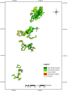
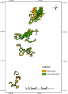
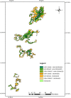
India has one of the largest assemblages of tropical biodiversity, with its unique floristic composition of endemic species. However, current forest cover assessment is performed via satellite-based forest surveys, which have many limitations. The present study, which was performed in the Eastern Ghats, analysed the satellite-based inventory provided by forest surveys and inferred from the results that this process no longer provides adequate information for quantifying forest degradation in an empirical manner. The study analysed 21 soil properties and generated a forest soil quality index of the Eastern Ghats, using principal component analysis. Using matrix modules and geospatial technology, we compared the forest degradation status calculated from satellite-based forest surveys with the degradation status calculated from the forest soil quality index. The Forest Survey of India classified about 1.8% of the Eastern Ghats' total area as degraded forests and the remainder (98.2%) as open, dense, and very dense forests, whereas the soil quality index results found that about 42.4% of the total area is degraded, with the remainder (57.6%) being non-degraded. Our ground truth verification analyses indicate that the forest soil quality index along with the forest cover density data from the Forest Survey of India are ideal tools for evaluating forest degradation.
Conflict of interest statement
Figures
References
-
- Cleghorn H. The forests and gardens of south India London: W.H. Allen & Company; 1861.
-
- Puri GS, Meher-Homij VM, Gupta RK, Puri S. Forest ecology. Oxford: IBH Publishing Company; 1960.
-
- Adolphus WHW. Consolidated working plan for the Salem forest division. Government Press; Madras Presidency, Madras: 1932.
-
- Thankam K. Working plan for the Chengalpattu forest division Government of Tamil Nadu. Government Press, Madras: 1959.
-
- Harikrishnan I. Working plan for the Salem forest division Government of Tamil Nadu. Government Press, Madras: 1967.
Publication types
MeSH terms
Substances
LinkOut - more resources
Full Text Sources
Other Literature Sources


