

Using a geographic information system to enhance patient access to point-of-care diagnostics in a limited-resource setting
- PMID: 26932155
- PMCID: PMC4774034
- DOI: 10.1186/s12942-016-0037-9
Using a geographic information system to enhance patient access to point-of-care diagnostics in a limited-resource setting
Abstract
Background: Rapid and accurate diagnosis drives evidence-based care in health. Point-of-care testing (POCT) aids diagnosis by bringing advanced technologies closer to patients. Health small-world networks are constrained by natural connectivity in the interactions between geography of resources and social forces. Using a geographic information system (GIS) we can understand how populations utilize their health networks, visualize their inefficiencies, and compare alternatives.
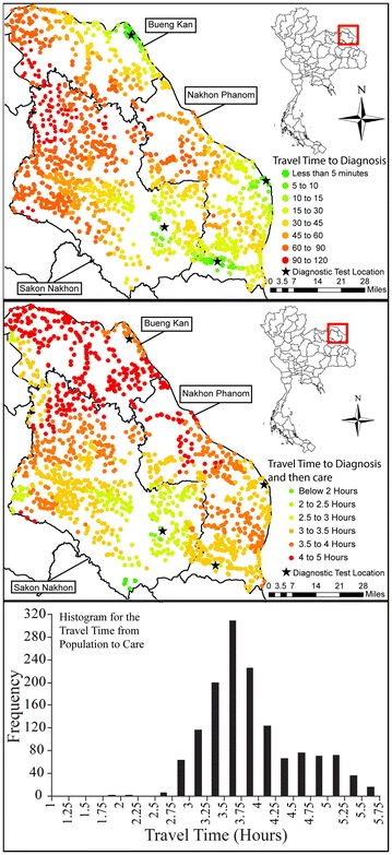
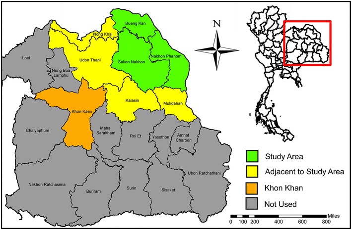
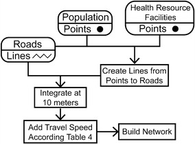
Methods: This project focuses on cardiac care resource in rural Isaan, Thailand. A health care access analysis was created using ArcGIS Network Analyst 10.1 from data representing aggregated population, roads, health resource facilities, and diagnostic technologies. The analysis quantified cardiac health care access and identified ways to improve it using both widespread and resource-limited strategies.
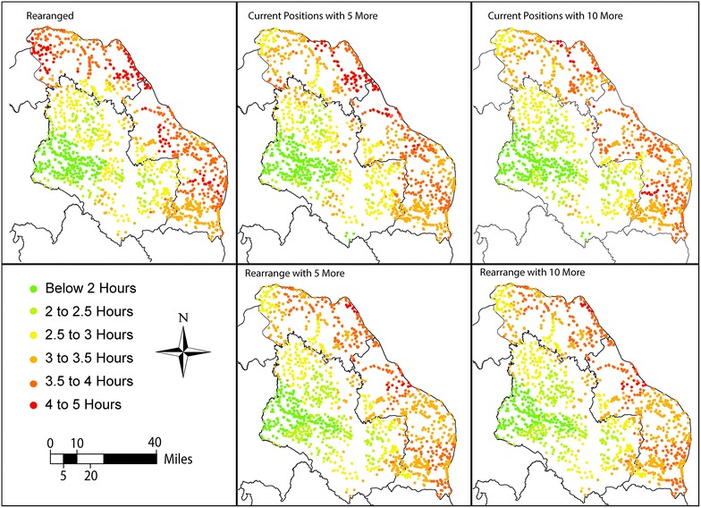
Results: Results indicated that having diagnostic technologies closer to populations streamlines critical care paths. GIS allowed us to compare the effectiveness of the implementation strategies and put into perspective the benefits of adopting rapid POCT within health networks.
Conclusions: Geospatial analyses derive high impact by improving alternative diagnostic placement strategies in limited-resource settings and by revealing deficiencies in health care access pathways. Additionally, the GIS provides a platform for comparing relative costs, assessing benefits, and improving outcomes. This approach can be implemented effectively by health ministries seeking to enhance cardiac care despite limited resources.
Figures


References
-
- Clark RA, Coffee N, Turner D, Eckert KA, van Gaans D, Wilkinson D, et al. Application of geographic modeling techniques to quantify spatial access to health services before and after an acute cardiac event. Health Serv Outcomes Res. 2012;125:2006–2014. - PubMed
-
- Coffee N, Turner D, Clark RA, Eckert K, Coombe D, Hugo G, et al. Measuring accessibility to cardiac services using geographic information systems. Appl Geogr. 2012;34:445–455. doi: 10.1016/j.apgeog.2012.01.007. - DOI
-
- Ranisinghe I, Turbull F, Tonkin A, Clark RA, Coffee N, Brieger D. Comparative effectiveness of population interventions to improve access to reperfusion for ST-segment-elevation myocardial infarction in Australia. Circ Cardiovasc Qual Outcomes. 2012;5:429–436. doi: 10.1161/CIRCOUTCOMES.112.965111. - DOI - PubMed
Publication types
MeSH terms
LinkOut - more resources
Full Text Sources
