Evaluation of unmanned aerial vehicle shape, flight path and camera type for waterfowl surveys: disturbance effects and species recognition
- PMID: 27020132
- PMCID: PMC4806640
- DOI: 10.7717/peerj.1831
Evaluation of unmanned aerial vehicle shape, flight path and camera type for waterfowl surveys: disturbance effects and species recognition
Abstract
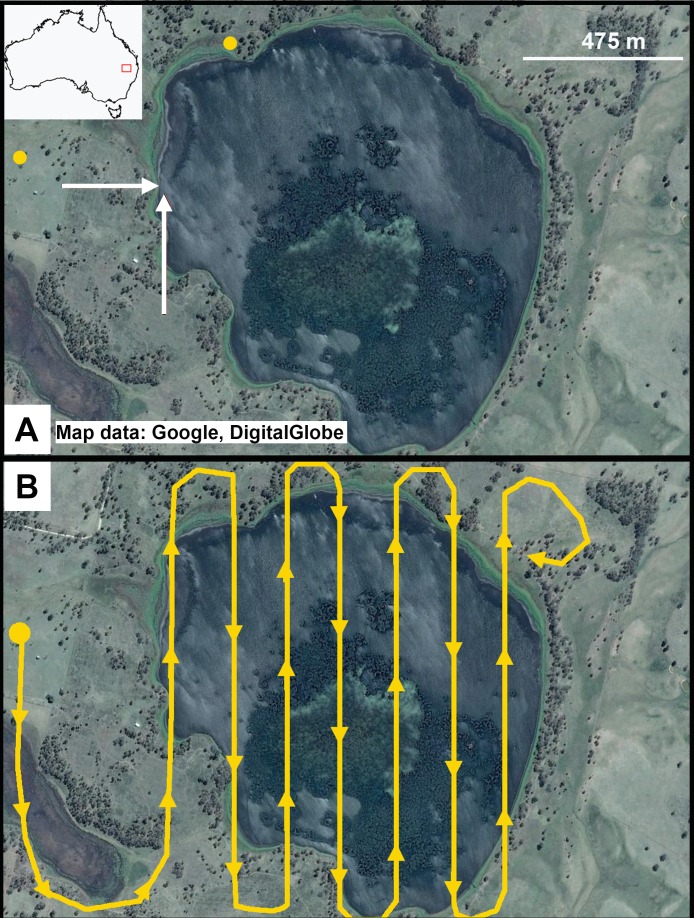
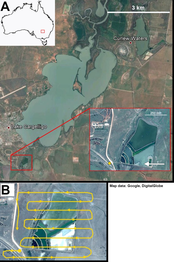
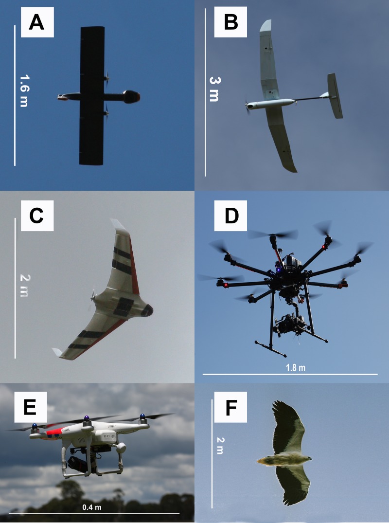
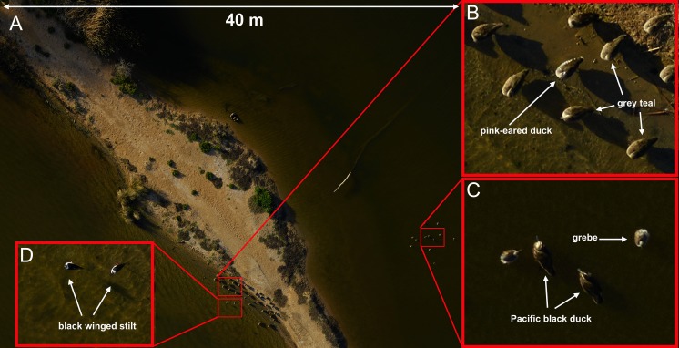
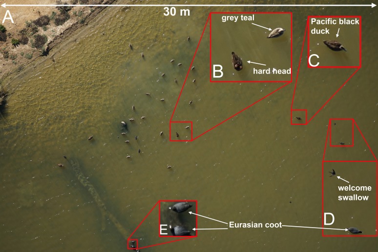
The use of unmanned aerial vehicles (UAVs) for ecological research has grown rapidly in recent years, but few studies have assessed the disturbance impacts of these tools on focal subjects, particularly when observing easily disturbed species such as waterfowl. In this study we assessed the level of disturbance that a range of UAV shapes and sizes had on free-living, non-breeding waterfowl surveyed in two sites in eastern Australia between March and May 2015, as well as the capability of airborne digital imaging systems to provide adequate resolution for unambiguous species identification of these taxa. We found little or no obvious disturbance effects on wild, mixed-species flocks of waterfowl when UAVs were flown at least 60m above the water level (fixed wing models) or 40m above individuals (multirotor models). Disturbance in the form of swimming away from the UAV through to leaving the water surface and flying away from the UAV was visible at lower altitudes and when fixed-wing UAVs either approached subjects directly or rapidly changed altitude and/or direction near animals. Using tangential approach flight paths that did not cause disturbance, commercially available onboard optical equipment was able to capture images of sufficient quality to identify waterfowl and even much smaller taxa such as swallows. Our results show that with proper planning of take-off and landing sites, flight paths and careful UAV model selection, UAVs can provide an excellent tool for accurately surveying wild waterfowl populations and provide archival data with fewer logistical issues than traditional methods such as manned aerial surveys.
Keywords: Aerial survey; Disturbance; Drone; Flight initiation distance; UAV.
Conflict of interest statement
The authors declare there are no competing interests.
Figures
References
-
- Abd-Elrahman A, Pearlstine L, Percival F. Development of pattern recognition algorithm for automatic bird detection from unmanned aerial vehicle imagery. Surveying and Land Information Science. 2005;65:37–46.
-
- Allan BM, Ierodiaconou D, Nimmo DG, Herbert M, Ritchie EG. Free as a drone: ecologists can add UAVs to their toolbox. Frontiers in Ecology and the Environment. 2015;13:354–355. doi: 10.1890/15.WB.015. - DOI
-
- Anderson K, Gaston KJ. Lightweight unmanned aerial vehicles will revolutionize spatial ecology. Frontiers in Ecology and the Environment. 2013;11:138–146. doi: 10.1890/120150. - DOI
-
- Bajzak D, Piatt JF. Computer-aided procedure for counting waterfowl on aerial photographs. Wildlife Society Bulletin. 1990;18:125–129.
-
- Baker-Gabb D. The feeding ecology and behaviour of seven species of raptor overwintering in coastal Victoria. Wildlife Research. 1984;11:517–532. doi: 10.1071/WR9840517. - DOI
LinkOut - more resources
Full Text Sources
Other Literature Sources