Review
. 2016 Jun 24;2(6):e1600026.
doi: 10.1126/sciadv.1600026. eCollection 2016 Jun.

Gravel-bed river floodplains are the ecological nexus of glaciated mountain landscapes

Affiliations
Review

Gravel-bed river floodplains are the ecological nexus of glaciated mountain landscapes

F Richard Hauer et al. Sci Adv. .

Abstract

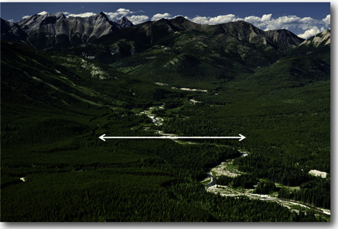
Gravel-bed river floodplains in mountain landscapes disproportionately concentrate diverse habitats, nutrient cycling, productivity of biota, and species interactions. Although stream ecologists know that river channel and floodplain habitats used by aquatic organisms are maintained by hydrologic regimes that mobilize gravel-bed sediments, terrestrial ecologists have largely been unaware of the importance of floodplain structures and processes to the life requirements of a wide variety of species. We provide insight into gravel-bed rivers as the ecological nexus of glaciated mountain landscapes. We show why gravel-bed river floodplains are the primary arena where interactions take place among aquatic, avian, and terrestrial species from microbes to grizzly bears and provide essential connectivity as corridors for movement for both aquatic and terrestrial species. Paradoxically, gravel-bed river floodplains are also disproportionately unprotected where human developments are concentrated. Structural modifications to floodplains such as roads, railways, and housing and hydrologic-altering hydroelectric or water storage dams have severe impacts to floodplain habitat diversity and productivity, restrict local and regional connectivity, and reduce the resilience of both aquatic and terrestrial species, including adaptation to climate change. To be effective, conservation efforts in glaciated mountain landscapes intended to benefit the widest variety of organisms need a paradigm shift that has gravel-bed rivers and their floodplains as the central focus and that prioritizes the maintenance or restoration of the intact structure and processes of these critically important systems throughout their length and breadth.

Keywords: Gravel-bed rivers; biodiversity; complexity; connectivity; coupled natural and human systems; disturbance; ecosystem conservation; floodplains; hydrogeomorphic.


Figures

Fig. 1
Fig. 1. The Flathead River in southeastern British Columbia.
Image illustrates the breadth of the gravel-bed river floodplain system and the hydrogeomorphic relationship between the surrounding catchment and the spatial and temporal complexity of the shifting habitat mosaic. The white arrow spans the width of the floodplain in this river segment (H. Locke, Yellowstone to Yukon Conservation Initiative).
Fig. 2
Fig. 2. The three-dimensional structure of the gravel-bed river.
Illustration shows the longitudinal, lateral, and vertical dynamics of the floodplain system. The floodplain landscape is created and maintained by biophysical processes that lead to a complex and dynamic habitat mosaic at the surface and in the subsurface. In this cutaway view, the hyporheic alluvial aquifer, characterized by river-origin water flowing through the gravel subsurface, is shown from valley wall to valley wall. The larger blue arrows signify the hyporheic waters that develop at the upper end of the floodplain and flow through the gravel substratum to discharge into the surface at the lower end of the floodplain following long flow pathways. The smaller arrows near the surface illustrate the water exchange between the surface waters and the upper hyporheic waters in the shallow bed sediments that occurs repeatedly along the length of the floodplain. The smaller U-shaped arrows at the interface between the hyporheic zone and phreatic groundwaters illustrate the small exchange that occurs between the hyporheic zone and deeper, phreatic groundwaters that are stored for longer periods of time. The black crescents represent the legacy of cut-and-fill alluviation, characterized by highly sorted open-network cobble substrata with interstitial flow pathways left behind as the river channel moves laterally on the floodplain surface (E. Harrington, eh illustration, Missoula, MT).
Fig. 3
Fig. 3. Biophysical characteristics of gravel-bed floodplains.
(A) Near-infrared image georeferenced with a high-resolution image showing classified temperatures of an upwelling location on a gravel-bed river floodplain. GW, groundwater. (B) Total abundance (±1 SD) (in cells per square centimeter) of substratum from cobbles at points of downwelling (n = 52), neutral (n = 19), and upwelling (n = 49) on a gravel-bed floodplain. Significant difference indicated by different letters above bars [P < 0.05, analysis of variance (ANOVA); P < 0.05, Tukey’s test]. (C) Stable isotope biplot for major invertebrate taxa (±1 SD). All taxa have d13C signatures that are more depleted than river dissolved or particulate organic matter. The extreme shift for some organisms is the likely contribution of methane through methanotrophs. Percent contribution of methane to those taxa in the hyporheic food web is shown in parentheses. (D) Relationship between groundwater recharge from the hyporheic zone on a gravel-bed floodplain stream reach and the number of bull trout redds (egg pockets) per stream reach. VHG, vertical hydraulic gradient.
Fig. 4
Fig. 4. Elk and wolf frequency distribution on a gravel-bed river floodplain and subpopulations of grizzly bears.
(A) A spatially explicit frequency distribution of radio-collared elk (purple) and wolves (red) and locations of elk kills by wolves (green stars). (B) A map of grizzly bear subpopulations in the United States–Canada transboundary area of the Y2Y region derived from fragmentation synthesis. Numerical values represent subpopulation estimates. The yellow dotted lines delineate fragmentation between subpopulations and follow fragmented gravel-bed river floodplains [modified with permission from the study by Proctor et al. (65)].
Fig. 5
Fig. 5. The gravel-bed river floodplain as the ecological nexus of regional biodiversity.
Illustration shows the complexity of the shifting habitat mosaic, the biophysical interactions among organisms from microbes to grizzly bears, and the importance of gravel-bed river floodplains as the nexus of glaciated mountain landscapes. (A) Microbes of the interstitial spaces of the gravel bed showing the products of processing of organic matter in the subsurface. (B) Crustaceans and insects that inhabit the gravels of the floodplain. (C) Temperature modification of surface habitats from upwelling hyporheic zone waters. (D) Native fishes spawning in floodplain gravels. (E) Riparian obligate birds. (F) Amphibian spawning in floodplain ponds and backwaters. (G) Ungulate herbivory of floodplain vegetation. (H) Wolf predation on ungulate populations. (I) Early-spring emergence of vegetation. (J) Wolf dens located along floodplain banks. (K) Use by grizzly bears and other carnivores as an intersection of landscape connectivity and sites of predation interactions (E. Harrington, eh illustration, Missoula, MT).
Fig. 6
Fig. 6. The gravel-bed river floodplain as affected by human structures.
(A to D) Illustration shows the loss of floodplain natural complexity as a result of human infrastructure shoreline housing and transportation corridor (A), rip-rap as a bank-hardening structure (B), geomorphic modification of levee construction (C), and a dam at the top of the floodplain (D). Note that, in this cutaway view, the hyporheic zone is highly reduced and modified from that shown in Figs. 2 and 5 as the river is converted into a functional single-thread river with little cut-and-fill alluviation across the floodplain. This results in the loss of highly sorted, open-network cobble substrata and further loss of the interstitial flow pathways of the hyporheic zone. When modified, most ecosystem components illustrated in Fig. 5 are significantly reduced or eliminated from the floodplain system (E. Harrington, eh illustration, Missoula, MT).

References

    1. Naiman R. J., Decamps H., Pollock M., The role of riparian corridors in maintaining regional biodiversity. Ecol. Appl. 3, 209–212 (1993). - PubMed
    1. Gurnell A. M., Bertoldi W., Corenblit D., Changing river channels: The roles of hydrological processes, plants and pioneer fluvial landforms in humid temperate, mixed load, gravel bed rivers. Earth-Sci. Rev. 111, 129–141 (2012).
    1. M. S. Lorang, F. R. Hauer, Fluvial Geomorphic Processes, in Methods in Stream Ecology, F. R. Hauer, G. A. Lamberti, Eds. (Academic Press/Elsevier, New York, ed. 2, 2006), pp. 145–168.
    1. Liu J., Dietz T., Carpenter S. R., Alberti M., Folke C., Moran E., Pell A. N., Deadman P., Kratz T., Lubchenco J., Ostrom E., Ouyang Z., Provencher W., Redman C. L., Schneider S. H., Taylor W. W., Complexity of coupled human and natural systems. Science 317, 1513–1516 (2007). - PubMed
    1. Grumbine R. E., What is ecosystem management? Conserv. Biol. 8, 27–38 (1994).

Publication types

LinkOut - more resources