

Probabilistic fire spread forecast as a management tool in an operational setting
- PMID: 27516943
- PMCID: PMC4965362
- DOI: 10.1186/s40064-016-2842-9
Probabilistic fire spread forecast as a management tool in an operational setting
Abstract
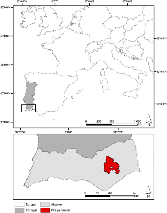
Background: An approach to predict fire growth in an operational setting, with the potential to be used as a decision-support tool for fire management, is described and evaluated. The operational use of fire behaviour models has mostly followed a deterministic approach, however, the uncertainty associated with model predictions needs to be quantified and included in wildfire planning and decision-making process during fire suppression activities. We use FARSITE to simulate the growth of a large wildfire. Probabilistic simulations of fire spread are performed, accounting for the uncertainty of some model inputs and parameters. Deterministic simulations were performed for comparison. We also assess the degree to which fire spread modelling and satellite active fire data can be combined, to forecast fire spread during large wildfires events.
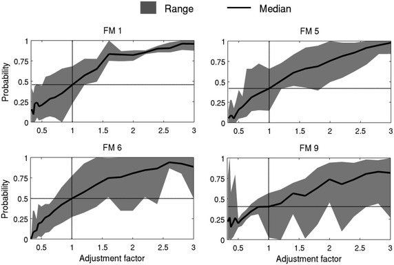
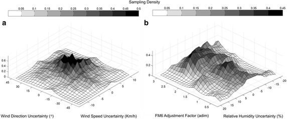
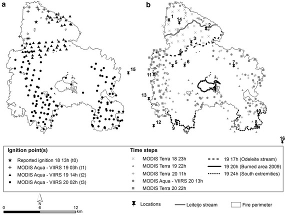
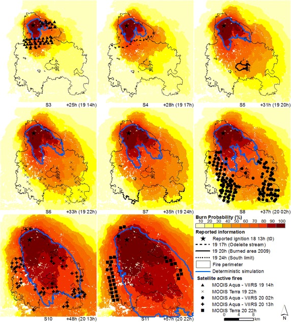
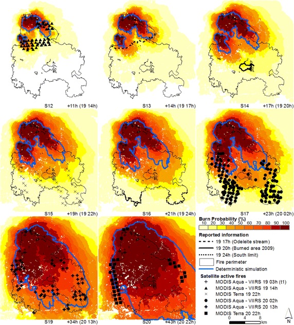
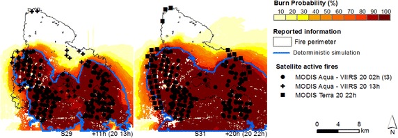
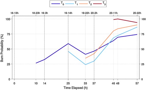
Results: Uncertainty was propagated through the FARSITE fire spread modelling system by randomly defining 100 different combinations of the independent input variables and parameters, and running the correspondent fire spread simulations in order to produce fire spread probability maps. Simulations were initialized with the reported ignition location and with satellite active fires. The probabilistic fire spread predictions show great potential to be used as a fire management tool in an operational setting, providing valuable information regarding the spatial-temporal distribution of burn probabilities. The advantage of probabilistic over deterministic simulations is clear when both are compared. Re-initializing simulations with satellite active fires did not improve simulations as expected.
Conclusion: This information can be useful to anticipate the growth of wildfires through the landscape with an associated probability of occurrence. The additional information regarding when, where and with what probability the fire might be in the next few hours can ultimately help minimize the negative environmental, social and economic impacts of these fires.
Keywords: FARSITE; Fire growth modelling; MODIS; Satellite active fires; Uncertainty assessment and propagation; VIIRS.
Figures


Similar articles
-
Deciphering the impact of uncertainty on the accuracy of large wildfire spread simulations.Sci Total Environ. 2016 Nov 1;569-570:73-85. doi: 10.1016/j.scitotenv.2016.06.112. Epub 2016 Jun 19. Sci Total Environ. 2016. PMID: 27333574
-
Fire spread predictions: Sweeping uncertainty under the rug.Sci Total Environ. 2017 Aug 15;592:187-196. doi: 10.1016/j.scitotenv.2017.03.106. Epub 2017 Mar 17. Sci Total Environ. 2017. PMID: 28319706
-
Assessing and reinitializing wildland fire simulations through satellite active fire data.J Environ Manage. 2019 Feb 1;231:996-1003. doi: 10.1016/j.jenvman.2018.10.115. Epub 2018 Nov 12. J Environ Manage. 2019. PMID: 30602261
-
Uncertainty and risk in wildland fire management: a review.J Environ Manage. 2011 Aug;92(8):1895-909. doi: 10.1016/j.jenvman.2011.03.015. Epub 2011 Apr 13. J Environ Manage. 2011. PMID: 21489684 Review.
-
Landscape--wildfire interactions in southern Europe: implications for landscape management.J Environ Manage. 2011 Oct;92(10):2389-402. doi: 10.1016/j.jenvman.2011.06.028. Epub 2011 Jul 8. J Environ Manage. 2011. PMID: 21741757 Review.
Cited by
-
The unprecedented 2014 Legionnaires' disease outbreak in Portugal: atmospheric driving mechanisms.Int J Biometeorol. 2018 Jul;62(7):1167-1179. doi: 10.1007/s00484-018-1520-8. Epub 2018 Mar 23. Int J Biometeorol. 2018. PMID: 29572569
-
A method to produce a flexible and customized fuel models dataset.MethodsX. 2023 May 19;10:102218. doi: 10.1016/j.mex.2023.102218. eCollection 2023. MethodsX. 2023. PMID: 37292241 Free PMC article.
References
-
- Alexander ME, Cruz MG. Limitations on the accuracy of model predictions of wildland fire behaviour: a state-of-the-knowledge overview. For Chron. 2013;89(3):372–383. doi: 10.5558/tfc2013-067. - DOI
-
- Anderson HE (1982) Aids to determining fuel models for estimating fire behaviour. General technical report INT-122. US Department of Agriculture, Forest Service, Intermountain Forest and Range Experiment Station, Ogden, UT
-
- Anderson KR, Flannigan MD, Reuter G (2005) Using ensemble techniques in fire-growth modelling. In: 6th Symposium on fire and forest meteorology, vol 2.4. Canmore, Alberta Amer Meteorol Soc, Boston, MA, 24–27 October 2005, pp 1–6
-
- Anderson K, Reuter G, Flannigan MD. Firegrowth modeling using meteorological data with random and systematic perturbations. Int J Wildland Fire. 2007;16:174–182. doi: 10.1071/WF06069. - DOI
-
- Anderson KR, Englefield P, Little JM, Reuter G. An approach to operational forest fire growth predictions for Canada. Int J Wildland Fire. 2009;18:893–905. doi: 10.1071/WF08046. - DOI
LinkOut - more resources
Full Text Sources
Other Literature Sources
