. 2016;30(5):869-880.
doi: 10.1080/13658816.2015.1065496. Epub 2015 Jul 13.

Movement analysis of free-grazing domestic ducks in Poyang Lake, China: a disease connection

Affiliations

Movement analysis of free-grazing domestic ducks in Poyang Lake, China: a disease connection

Diann J Prosser et al. Int J Geogr Inf Sci. 2016.

Abstract

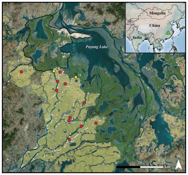
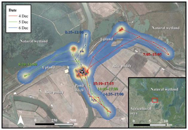
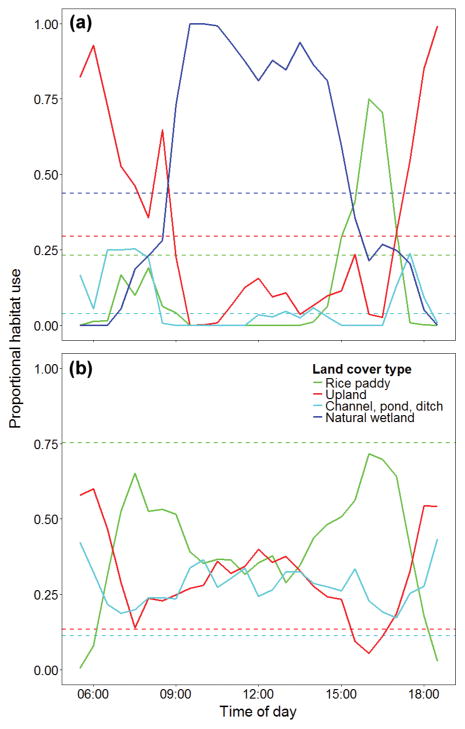
Previous work suggests domestic poultry are important contributors to the emergence and transmission of highly pathogenic avian influenza throughout Asia. In Poyang Lake, China, domestic duck production cycles are synchronized with arrival and departure of thousands of migratory wild birds in the area. During these periods, high densities of juvenile domestic ducks are in close proximity to migratory wild ducks, increasing the potential for the virus to be transmitted and subsequently disseminated via migration. In this paper, we use GPS dataloggers and dynamic Brownian bridge models to describe movements and habitat use of free-grazing domestic ducks in the Poyang Lake basin and identify specific areas that may have the highest risk of H5N1 transmission between domestic and wild birds. Specifically, we determine relative use by free-grazing domestic ducks of natural wetlands, which are the most heavily used areas by migratory wild ducks, and of rice paddies, which provide habitat for resident wild ducks and lower densities of migratory wild ducks. To our knowledge, this is the first movement study on domestic ducks, and our data show potential for free-grazing domestic ducks from farms located near natural wetlands to come in contact with wild waterfowl, thereby increasing the risk for disease transmission. This study provides an example of the importance of movement ecology studies in understanding dynamics such as disease transmission on a complicated landscape.

Keywords: disease transmission; domestic poultry; dynamic Brownian bridge movement model.


Conflict of interest statement

statement No potential conflict of interest was reported by the authors.

Figures

Figure 1
Figure 1
Map of Poyang Lake area with free-grazing domestic duck shelters surveyed in October 2007 is shown in white. Farms with marked birds are shown in red (farms > 1.5 km from natural wetlands) and yellow (border farms) and labeled by farm number. Green triangle in inset indicates relative location of Poyang Lake within China. Dark green areas bordering southern edge of Poyang Lake indicate natural wetland. Tan shading indicates rice paddy habitat. Black outline delineates the Poyang Lake National Nature Reserve. Base imagery source: ESRI, DigitalGlobe, GeoEye, i-cubed, Earthstar Geographics, CNES/Airbus DS, USDA, USGS, AEX, Getmapping, Aerogrid, IGN, IGP, swisstopo, and the GIS User Community, 2015.
Figure 2
Figure 2
Diurnal locations, paths and utilization distribution estimating relative use of a free-grazing domestic duck over three days in December 2007 near Poyang Lake. Blue shading indicates areas of relatively low use, while orange and red areas indicate areas of high use. Time labels are colored by date and correspond to individual foraging trips away from the farm shelter. White triangle denotes farm shelter. Red square on inset indicates farm location in relation to boundary between agricultural area and natural wetland. Base imagery source: Google Earth (version 7.1.2, Google, Mountain View, CA, 2015).
Figure 3
Figure 3
Average proportional habitat use of habitat types within 50% UD contours bounding 30 min time steps for (a) 20 birds at farms > 1.5 km from natural wetlands and (b) 5 birds from farms ≤ 1.5 km from natural wetlands (border farms). Dashed horizontal lines represent the proportional availability of each habitat type within 1.5 km of farm center.

Similar articles

Cited by

References

    1. Beyer HK. [Accessed 29 January 2015];Geospatial modelling environment software. 2014 [online]. Available from: www.spatialecology.com.
    1. Bin MS, et al. Rice production systems and avian influenza: interactions between mixed-farming systems, poultry and wild birds. Waterbirds. 2010;33(sp1):219–230. doi: 10.1675/063.033.s116. - DOI
    1. Brown JD, Stallknecht DE, Swaynet DE. Experimental infection of swans and geese with highly pathogenic avian influenza virus (H5N1) of Asian lineage. Emerging Infectious Diseases. 2008;14:136–142. doi: 10.3201/eid1401.070740. - DOI - PMC - PubMed
    1. Byrne ME, et al. Using dynamic Brownian bridge movement modelling to measure temporal patterns of habitat selection. Journal of Animal Ecology. 2014;83:1234–1243. doi: 10.1111/1365-2656.12205. - DOI - PubMed
    1. Cappelle J, et al. Risks of avian influenza transmission in areas of intensive free-ranging duck production with wild waterfowl. EcoHealth. 2014;11:109–119. doi: 10.1007/s10393-014-0914-2. - DOI - PMC - PubMed

LinkOut - more resources