

High resolution mapping of development in the wildland-urban interface using object based image extraction
- PMID: 27752649
- PMCID: PMC5061309
- DOI: 10.1016/j.heliyon.2016.e00174
High resolution mapping of development in the wildland-urban interface using object based image extraction
Abstract
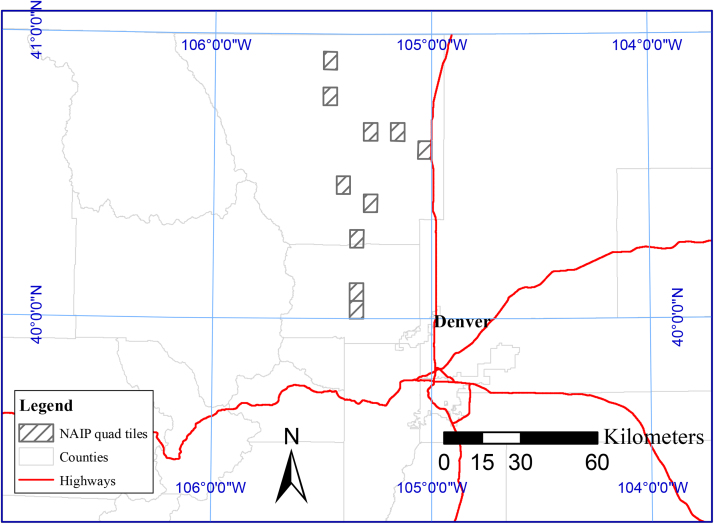
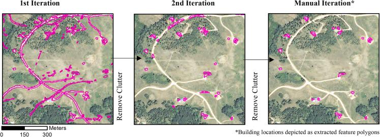
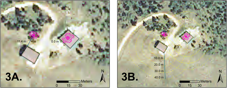
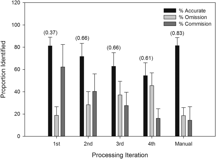
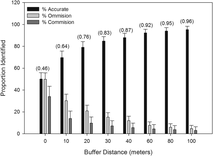
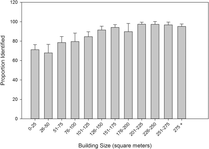
The wildland-urban interface (WUI), the area where human development encroaches on undeveloped land, is expanding throughout the western United States resulting in increased wildfire risk to homes and communities. Although census based mapping efforts have provided insights into the pattern of development and expansion of the WUI at regional and national scales, these approaches do not provide sufficient detail for fine-scale fire and emergency management planning, which requires maps of individual building locations. Although fine-scale maps of the WUI have been developed, they are often limited in their spatial extent, have unknown accuracies and biases, and are costly to update over time. In this paper we assess a semi-automated Object Based Image Analysis (OBIA) approach that utilizes 4-band multispectral National Aerial Image Program (NAIP) imagery for the detection of individual buildings within the WUI. We evaluate this approach by comparing the accuracy and overall quality of extracted buildings to a building footprint control dataset. In addition, we assessed the effects of buffer distance, topographic conditions, and building characteristics on the accuracy and quality of building extraction. The overall accuracy and quality of our approach was positively related to buffer distance, with accuracies ranging from 50 to 95% for buffer distances from 0 to 100 m. Our results also indicate that building detection was sensitive to building size, with smaller outbuildings (footprints less than 75 m2) having detection rates below 80% and larger residential buildings having detection rates above 90%. These findings demonstrate that this approach can successfully identify buildings in the WUI in diverse landscapes while achieving high accuracies at buffer distances appropriate for most fire management applications while overcoming cost and time constraints associated with traditional approaches. This study is unique in that it evaluates the ability of an OBIA approach to extract highly detailed data on building locations in a WUI setting.
Keywords: Environmental science; Geography.
Figures
Similar articles
-
The wildland-urban interface in the United States based on 125 million building locations.Ecol Appl. 2022 Jul;32(5):e2597. doi: 10.1002/eap.2597. Epub 2022 Jun 5. Ecol Appl. 2022. PMID: 35340097
-
Assessing wildfire exposure in the Wildland-Urban Interface area of the mountains of central Argentina.J Environ Manage. 2017 Jul 1;196:499-510. doi: 10.1016/j.jenvman.2017.03.058. Epub 2017 Mar 25. J Environ Manage. 2017. PMID: 28347968
-
Mapping the wildland-urban interface at municipal level for wildfire exposure analysis in mainland Portugal.J Environ Manage. 2024 Sep;368:122098. doi: 10.1016/j.jenvman.2024.122098. Epub 2024 Aug 9. J Environ Manage. 2024. PMID: 39126844
-
The Chemistry of Fires at the Wildland-Urban Interface.Washington (DC): National Academies Press (US); 2022 Sep 15. Washington (DC): National Academies Press (US); 2022 Sep 15. PMID: 36657007 Free Books & Documents. Review.
-
Face-to-face with scorching wildfire: potential toxicant exposure and the health risks of smoke for wildland firefighters at the wildland-urban interface.Lancet Reg Health Am. 2023 Mar 26;21:100482. doi: 10.1016/j.lana.2023.100482. eCollection 2023 May. Lancet Reg Health Am. 2023. PMID: 37008196 Free PMC article. Review.
Cited by
-
Remote Sensing of Wildland Fire-Induced Risk Assessment at the Community Level.Sensors (Basel). 2018 May 15;18(5):1570. doi: 10.3390/s18051570. Sensors (Basel). 2018. PMID: 29762504 Free PMC article.
-
Mapping the wildland-urban interface in California using remote sensing data.Sci Rep. 2022 Apr 6;12(1):5789. doi: 10.1038/s41598-022-09707-7. Sci Rep. 2022. PMID: 35388077 Free PMC article.
-
Still standing: Recent patterns of post-fire conifer refugia in ponderosa pine-dominated forests of the Colorado Front Range.PLoS One. 2020 Jan 15;15(1):e0226926. doi: 10.1371/journal.pone.0226926. eCollection 2020. PLoS One. 2020. PMID: 31940320 Free PMC article.
-
Global expansion of wildland-urban interface intensifies human exposure to wildfire risk in the 21st century.Sci Adv. 2024 Nov 8;10(45):eado9587. doi: 10.1126/sciadv.ado9587. Epub 2024 Nov 8. Sci Adv. 2024. PMID: 39514665 Free PMC article.
References
-
- Alexandre P.M., Stewart S.I., Mockrin M.H., Keuler N.S., Syphard A.D., Bar-Massada A., Radeloff V.C. The relative impacts of vegetation, topography and spatial arrangement on building loss to wildfires in case studies of California and Colorado. Landscape Ecol. 2015:1–16.
-
- Bar-Massada A., Stewart S.I., Hammer R.B., Mockrin M.H., Radeloff V.C. Using structure locations as a basis for mapping the wildland urban interface. J. Environ. Manage. 2013;128:540–547. - PubMed
-
- Calkin D.E., Rieck J.D., Hyde K.D., Kaiden J.D. Built structure identification in wildland fire decision support. Int. J. Wildland Fire. 2011;20(1):78–90.
-
- Clark J.K., McChesney R., Munroe D.K., Irwin E.G. Spatial characteristics of exurban settlement pattern in the United States. Landscape Urban Plan. 2009;90(3):178–188.
LinkOut - more resources
Full Text Sources
Other Literature Sources
