. 2016 Oct 25:7:13243.
doi: 10.1038/ncomms13243.

Rapid submarine ice melting in the grounding zones of ice shelves in West Antarctica

Affiliations

Rapid submarine ice melting in the grounding zones of ice shelves in West Antarctica

Ala Khazendar et al. Nat Commun. .

Abstract

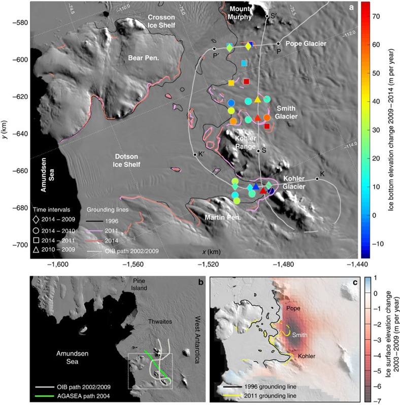
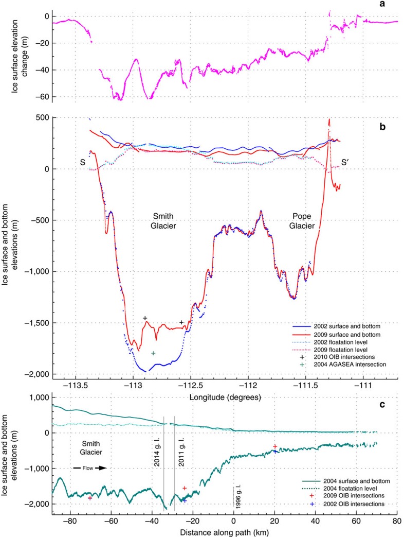
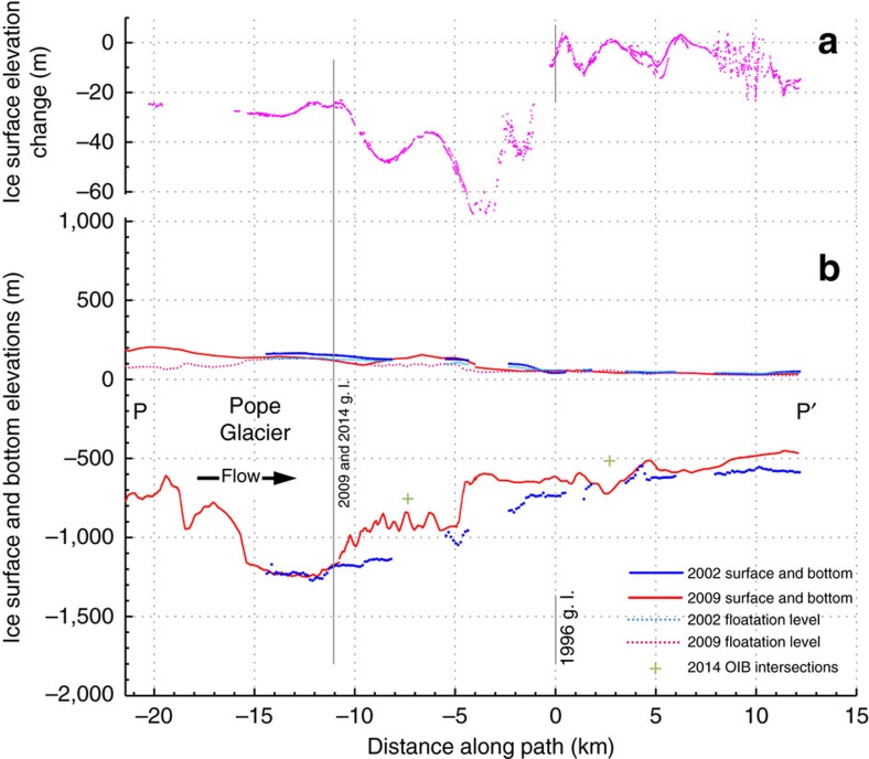
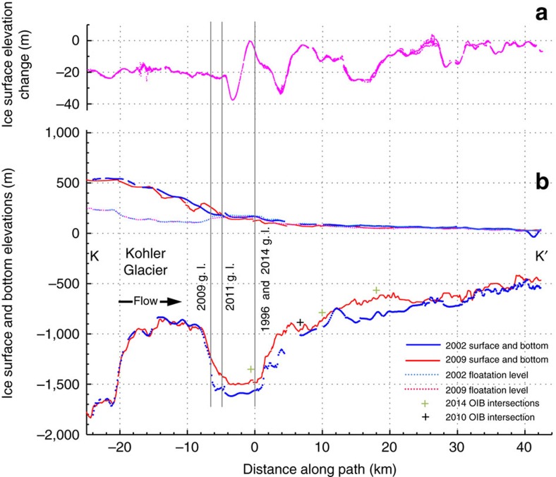
Enhanced submarine ice-shelf melting strongly controls ice loss in the Amundsen Sea embayment (ASE) of West Antarctica, but its magnitude is not well known in the critical grounding zones of the ASE's major glaciers. Here we directly quantify bottom ice losses along tens of kilometres with airborne radar sounding of the Dotson and Crosson ice shelves, which buttress the rapidly changing Smith, Pope and Kohler glaciers. Melting in the grounding zones is found to be much higher than steady-state levels, removing 300-490 m of solid ice between 2002 and 2009 beneath the retreating Smith Glacier. The vigorous, unbalanced melting supports the hypothesis that a significant increase in ocean heat influx into ASE sub-ice-shelf cavities took place in the mid-2000s. The synchronous but diverse evolutions of these glaciers illustrate how combinations of oceanography and topography modulate rapid submarine melting to hasten mass loss and glacier retreat from West Antarctica.


Figures

Figure 1
Figure 1. The study area of the Dotson and Crosson ice shelves and their tributary glaciers.
(a) The repeat flight path of the 2002 and 2009 Operation IceBridge (OIB) campaigns, with the letters S-S′, P-P′ and K-K′ marking the endpoints of the profiles in Figs 2, 3, 4. Colour scale shows bottom ice elevation changes at crossover locations of non-repeating OIB tracks between the years 2009 and 2014. At each crossover location, the bottom elevation of the earlier year is subtracted from that of the latter, hence positive values indicate bottom ice loss. The differences found are then averaged over the length of the time interval to facilitate comparisons. Uncertainty varies between ∼35 m per year for the 1-year interval to ∼7 m per year for the 5-year interval (Methods). Grounding lines are from refs and , and background image is from the 2008–2009 MODIS Mosaic of Antarctica (MOA). (b) The study area of Fig. 1a located on a map of the ASE region by the white rectangle showing the flight paths analysed here of the 2002 and 2009 OIB campaigns, and the 2004 AGASEA campaign along the Smith-Kohler glacier trunk. (c) Surface lowering rates for the period 2003–2009 adapted from ref. . The authors used ICESat-1 measurements with the necessary corrections, with ATM and other data products applied as additional constraints to the surface shape and elevation time series.
Figure 2
Figure 2. Smith Glacier radar transects showing basal ice loss and corresponding surface elevation change between the years 2002 and 2009.
(a) Surface elevation change between 2002 and 2009 as measured by ATM laser altimetry on the across-flow Smith Glacier (SG) transect delimited by S-S′ shown in Fig. 1a. (b) The 2002 and 2009 ice surface and bottom MCoRDS profiles of SG along the transect delimited by S-S′ in Fig. 1a. The hydrostatic floatation levels were found by taking freeboard elevation to be 0.12 of ice thickness, which was inferred from floating ice in Figs 3b and 4b; and taking sea surface to be at −33.9 m relative to the WGS84 ellipsoid, which was found from ATM 2009 measurements of ocean surface height in front of the Dotson Ice Shelf. The 2002 ice bottom appears partially dotted at some locations due to the lower density of available measurements there. (c) Ice surface and bottom along-flow profiles following the entire 2004 AGASEA trajectory shown in Fig. 1b. In this and subsequent figures the vertical grey lines mark grounding line locations. The 1996 grounding line location is taken as the origin of the x axis representing the distance along the flight path, and is indicated by a shorter grey line when bed topography is not available at its location.
Figure 3
Figure 3. Pope Glacier radar transects showing basal ice losses and corresponding surface elevation changes between the years 2002 and 2009.
(a) Surface elevation change between 2002 and 2009 as measured by ATM laser altimetry on the along-flow Pope Glacier (PG) transect delimited by P-P′ shown in Fig. 1a. (b) The 2002 and 2009 ice surface and bottom MCoRDS profiles of PG along the transect delimited by P-P′ in Fig. 1a. The hydrostatic floatation levels were found as described in the caption of Fig. 2b.
Figure 4
Figure 4. Kohler Glacier radar transects showing basal ice losses and corresponding surface elevation changes between the years 2002 and 2009.
(a) Surface elevation change between 2002 and 2009 as measured by ATM laser altimetry on the along-flow Kohler Glacier (KG) transect delimited by K-K′ shown in Fig. 1a. (b) The 2002 and 2009 ice surface and bottom MCoRDS profiles of KG along the transect delimited by K-K′ in Fig. 1a. The hydrostatic floatation levels were found as described in the caption of Fig. 2b.
Figure 5
Figure 5. Radar sounding data show evidence of an isolated area of grounding between two floating portions of the Kohler Glacier grounding zone.
(a) Across a region of nearly constant ice thickness (dashed magenta lines), (b) the approximately 20 dB drop in relative bed echo power is consistent with a basal interface transition from ocean water to bedrock indicating that the glacier is grounded in the part of the profile delimited by the magenta rectangle. (c) A 2009 MCoRDS radargram of the Kohler Glacier grounding zone.

References

    1. Sutterley T. C. et al.. Mass loss of the Amundsen Sea embayment of West Antarctica from four independent techniques. Geophys. Res. Lett. 41, 8421–8428 (2014).
    1. Harig C. & Simons F. J. Accelerated West Antarctic ice mass loss continues to outpace East Antarctic gains. Earth Planet. Sci. Lett. 415, 134–141 (2015).
    1. Depoorter M. A. et al.. Calving fluxes and basal melt rates of Antarctic ice shelves. Nature 502, 89–92 (2013). - PubMed
    1. Rignot E., Jacobs S., Mouginot J. & Scheuchl B. Ice shelf melting around Antarctica. Science 341, 266–270 (2013). - PubMed
    1. Jenkins A. et al.. Observations beneath Pine Island Glacier in West Antarctica and implications for its retreat. Nat. Geosci. 3, 468–472 (2010).

Publication types