. 2016 Oct 28;354(6311):438-441.
doi: 10.1126/science.aag0519. Epub 2016 Oct 27.

Gravity field of the Orientale basin from the Gravity Recovery and Interior Laboratory Mission

Affiliations

Gravity field of the Orientale basin from the Gravity Recovery and Interior Laboratory Mission

Maria T Zuber et al. Science. .

Abstract

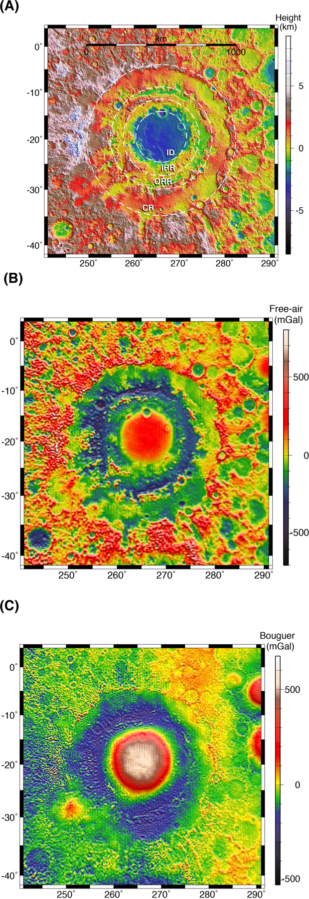
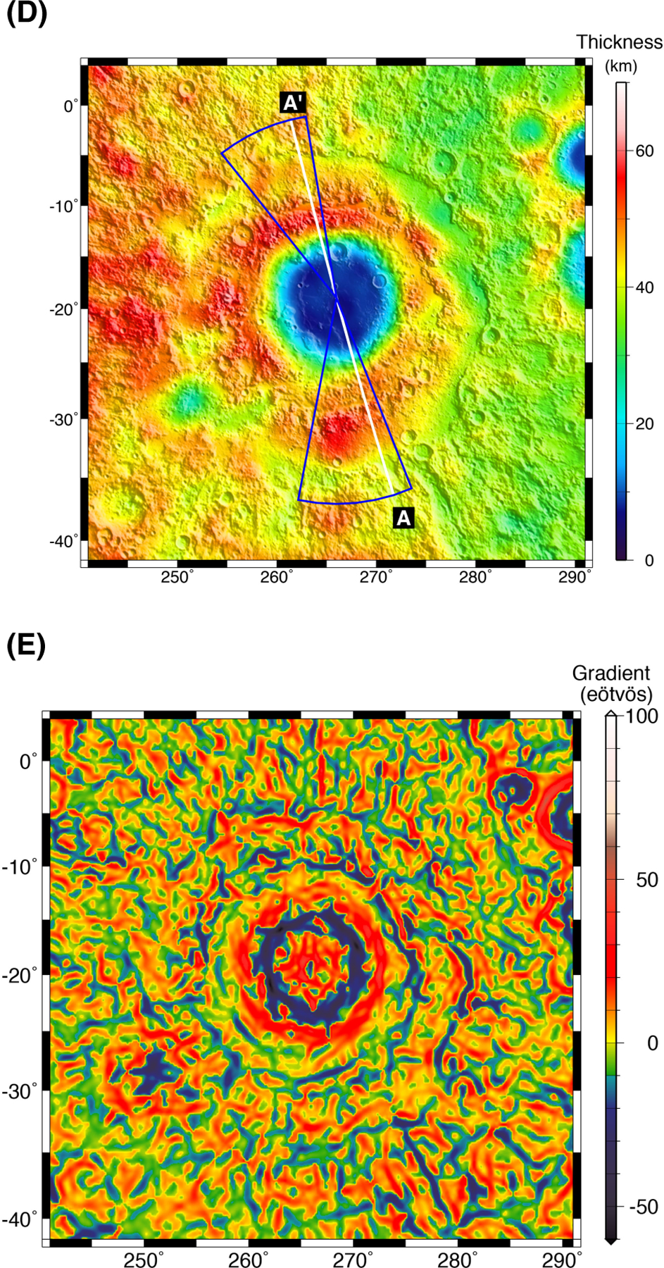
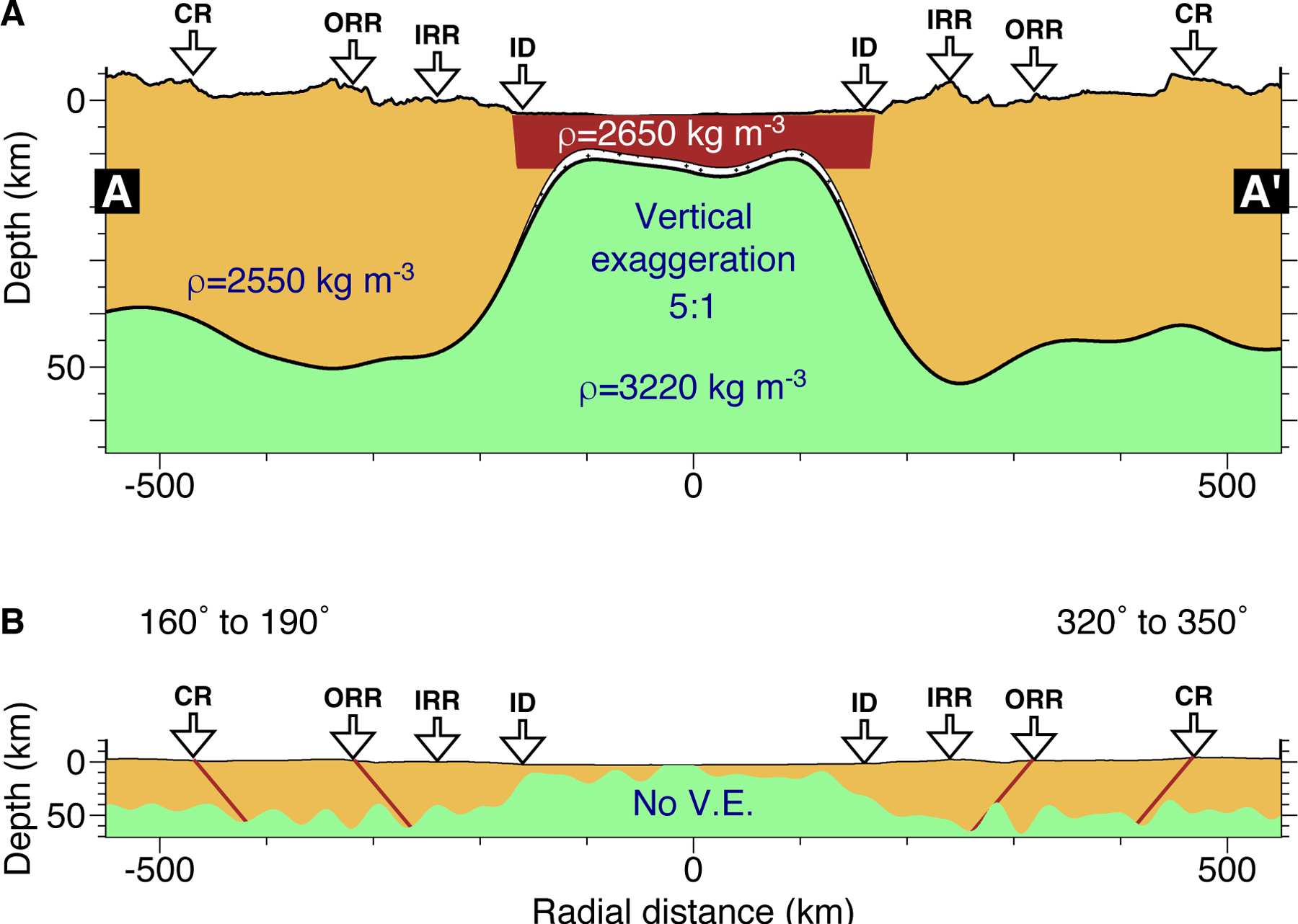
The Orientale basin is the youngest and best-preserved major impact structure on the Moon. We used the Gravity Recovery and Interior Laboratory (GRAIL) spacecraft to investigate the gravitational field of Orientale at 3- to 5-kilometer (km) horizontal resolution. A volume of at least (3.4 ± 0.2) × 106 km3 of crustal material was removed and redistributed during basin formation. There is no preserved evidence of the transient crater that would reveal the basin's maximum volume, but its diameter may now be inferred to be between 320 and 460 km. The gravity field resolves distinctive structures of Orientale's three rings and suggests the presence of faults associated with the outer two that penetrate to the mantle. The crustal structure of Orientale provides constraints on the formation of multiring basins.


Figures

Fig. 1.
Fig. 1.. High-resolution maps.
(A) Topography, (B) free-air anomaly (1mGal= 1 milliGalileo = 0−5 m s−2), (C) Bouguer anomaly, (D) crustal thickness over shaded-relief topography, and (E) Bouguer gravity gradient (1 Eotovos = 10−4 mGal m−1 = 10−9 s−2) of the Orientale basin and surroundings. Dashed lines in (A) from innermost to outermost correspond to the Inner Depression (ID), Inner Rook ring (IRR), Outer Rook ring (ORR), and Cordillera ring (CR). The solid white line in (D) shows the location of the cross-sectional profile A-A’ in Fig. 2a. Blue lines show the locations of the azimuthally averaged cross-sections in Fig. 2b. Topography is updated from Lunar Observer Laser Altimeter (LOLA) (11) map LDEM_64, 0.015625° spatial resolution. To highlight short-wavelength structure, we have subtracted spherical harmonic degrees and orders less than 6 from the Bouguer gravity field. Calculation of crustal thickness and Bouguer gravity gradient are discussed in the Supplementary Online material (9).
Fig. 2.
Fig. 2.. Crustal cross-section.
(A) Subsurface structure of the Orientale basin along the profile shown in Fig. 1D, from southeast to northwest. Crust is shown as tan, melt sheet as red, and mantle as green. Arrows above the cross-section denote, inward to outward, Orientale’s Inner Depression (ID), Inner Rook ring (IRR), Outer Rook ring (ORR), and Cordillera ring (CR). The heavy solid line indicates the base of the crust in the presence of a melt sheet that is 10 km thick, 350 km in diameter, and 2650 kg m−3 in density; the thin solid line indicates the base of the crust if the melt sheet density is identical to that of the crust. Vertical exaggeration (V.E.) is 5:1. (B) As in (A), with no vertical exaggeration and 3x higher resolution filter for downward continuation (9) having higher resolution by a factor of 3, the profile is azimuthally averaged in sectors (azimuth measured clockwise from north, see Fig. 1D) to suppress noise. Red lines give the location of proposed faults dipping inward at 50° dip angle from the nominal surface positions of the ORR and CRR. Other variations in crust-mantle boundary depth suggest the presence of additional faults.

References

    1. Wilhelms DE, The Geologic History of the Moon U.S. Geol. Survey Prof. Paper 1348 (US Govt. Printing Office, Washington, DC, 1987), 302 pp.
    1. Spudis PD, The Geology of Multiring Impact Basins: The Moon and Other Planets. (Cambridge Univ. Press, Cambridge, England, 1993), 277 pp.
    1. Zuber MT, Lehman DH, Smith DE, Hoffman TL, Asmar SW, Gravity Recovery and Interior Laboratory (GRAIL): Mapping the lunar interior from crust to core. Space Sci. Rev 178, doi: 10.1007/s11214-012-9952-7 (2013). - DOI
    1. Stoffler D et al., Cratering history and lunar chronology. Rev. Mineral. Geochem 60, 519–596 (2006).
    1. Head JW, Orientale multi-ringed basin interior and implications for the petrogenesis of lunar highland samples. Moon 11, 327–356 (1974).

LinkOut - more resources